 ACON
- VA/NC/SC
ACON
- VA/NC/SC
The
Atlantic Coast Observer Network: Virginia, North Carolina, South Carolina
http://www.pilot.infi.net/~bsmoot/acon.htm
SUMMARY
OF CLIMATOLOGICAL DATA
AUGUST
2000
ACON
- VA/NC/SC
The
Atlantic Coast Observer Network: Virginia, North Carolina, South Carolina
http://www.pilot.infi.net/~bsmoot/acon.htm
SUMMARY
OF CLIMATOLOGICAL DATA
AUGUST
2000
...July & August Nearly Identical
for Most Stations...
...Virginia and Eastern Two-thirds
of North Carolina: Cooler and Wetter...
...South Carolina Continues
With Below Normal Rainfall...
The months of July and August 2000 were amazingly similar. After compiling your August data, it's a striking note that nearly all of the stations had maximum, minimum, and mean temperatures within 1 degree of those recorded for July. The Mid-Atlantic trough was persistent and the weather virtually the same over our ACON area. The coastal areas remained above average in the precip category while again a dry spot was noted over northwestern Virginia. And the extremely dry areas noted in July over southwestern and south-central NC into western SC continued that way. Thunderstorms days were up a bit over the region (from July to August) and precipitation was up in most areas as well. Days saw more cloudy conditions than normal over the northern 2/3 of the region and this helped keep daytime highs below average and nighttime lows above average. Rainfall days increased over July and were above the August average.
Severe thunderstorms rolled across Northern Virginia on the 7th causing widespread power outages and wind damage. See the article excerpted below sent in by Erica Page (FCH). An Internet link to a report on these storms is included.
Drier
than normal conditions were reported in the North Carolina mountains (from
AVL and BRE) and in the Charlotte area. Of note, Bob Keehn's Brevard
yearly rainfall total is running over 11" below normal! All of South
Carolina reported deficient rainfall when looking at departures from the
norm.
|
|
|
Temperature |
Average Temperature |
Average Temperature |
Precipitation |
Precipitation |
|
|
|
|
|
|
|
|
|
|
|
|
|
|
|
|
|
|
|
|
|
North Myrtle Beach |
North Myrtle Beach |
|
Regional Monthly Precipitation Summary and Discussions for Virginia, prepared and archived by NWS AKQ, can be located on its Web homepage at: http://tgsv5.nws.noaa.gov/er/akq/climate.htm Patrick Maloit works hard on these monthly products, taking over for recently departed Tim Armstrong who also did an excellent job with them.
Still Available Frances' offer to share his collection of weather articles, bulletins, pamphlets gathered over many years is still available for the asking!! You can call him at 804-438-6604. He's 87 years old and has 75 years of weather work under his belt, so you know he's got a great selection.
Member
Profile

ACON charter member Eleanor Vallier-Talbot Our Charleston representative is our profiled subject this month. Several of you know and have met her from the days of the International Weather Watchers. Eleanor is a native of Quincy, MA, having 2 sisters and a brother. In 1992, she married Dean Talbot. She attended the University of Lowell (now University of Massachusetts at Lowell) majoring in Meteorology from September 1978 to May 1980 and later transferred to Lyndon State College, Lyndonville, VT, graduating with a Bachelor of Science degree in Meteorology May 1982. Her weather work experiences include: part time weather observer for Blue Hill Observatory, Milton, MA from December 1982 to May 1985; employment with the National Weather Service: Meteorologist Intern at NWS Providence, RI May 1985 to December 1989, Meteorologist/Forecaster at NWS Portland, ME December 1989 to September 1993, Meteorologist and Outreach Coordinator for K-12 Education Programs at NWS Taunton, MA -- September 1993 to September 1998, Senior Meteorologist and K-12 Education Coordinator at NWS Charleston, SC September 1998 to present. Eleanor's memberships/activities
include: contributing author, WeatherThe Nature Company Guides,
published by Time-Life Books and The Nature Company, ISBN 0-8094-9374-8.
Chapter 2, "Understanding the Weather." April 1996; Contributing
Author, Hurricane Bob, August 16-August 20, 1991A Brief History,
published by the Blue Hill Meteorological Observatory; article, "Hurricane
Bob in Maine and New Hampshire." 1992; Member--American Meteorological
Society, National Weather Association, Mt. Washington Observatory;
Charter Member International Weather Watchers organization for mainly
amateur weather enthusiastsalso organized and hosted the 1st Annual
Meeting at the Taunton Holiday Inn with the Atlantic Coast Observer Network
-- August 1994, Served on Board of Directors; Charter Member Atlantic
Coast Observer Network active amateur weather observers from Maine to
Georgia; Organized and hosted 7th Annual Meeting in Portland,
ME in June 1992; Held 9th Annual Meeting jointly with the International
Weather Watchers August 1994; Past coordinator for RI/SE MA (October
1985 to December 1989) and ME/NH (March 1990 to September 1993);
Contributor for VA/NC/SC ACON
Eleanor has also served as
a presenter at several national meetings, including the 7th and 8th Symposia
on Education, held in conjunction with the AMS Annual Meetings in Long
Beach, CA, (1997) and Phoenix, AZ, (1998) and the 25th AMS Conference on
Broadcast Meteorology,
She is the recipient of several Special Act Awards for work on Educational Outreach Programs at WFOs Taunton and Charleston. Recipient of the 1996 NWS Eastern Region EEO Employee of the Year Award, for "outstanding performance as Outreach Coordinator at NWSFO Boston. Your contributions have introduced thousands of students to meteorology and hydrology as an exciting career choice." Finalist for the 1995 award for Outstanding Technical Employee of the Year, by the Greater Boston Federal Executive Board--Excellence in Government Awards. In addition, Eleanor is a Volunteer Scientist for the 1994-95 and 1995-96 school yearsScience-by-Mail program through the Museum of Science, Boston. Hobbies include weather (!),
bowling, travel, surfing the Net and spending time with her husband and
cats!!
|
NOTES FROM "AROUND THE LEAGUE"
Virginia:
Annandale - Lowell sends these notes: "August was wetter and cooler than average which is also the story of this summer. The total rainfall was +0.98 departure from the average. The mean temp. was -1.5 deg. below normal. It was the coolest August since 1996 and the seventh wettest here in the last 20 years with 8 days with thundershowers or thunderstorms. August had only 3 days of 90 deg. or more the least since 1996 with an average maximum temperature being the lowest since 1992. The high humidity and cloudy nights gave August the lowest average temperature range of 15.1 deg.. in the last 20 years; the old record was 16.3 in 1989. It was the cloudiest August in the records of this station that have been kept for sky cover for the last 15 years. August had 13 days with measurable precipitation the most since 1994. The average minimum relative humidity was the highest since 1990. The highest barometric pressure was 30.38 inches the most since 1986 with 1992 being close with 30.37 inches. "
Arlington - NWS WBC's Dewey Walston notes DCA's mean temp was 3.4o below normal while the rainfall departure was -0.14". "NO RECORDS WERE SET AT NATIONAL AIRPORT DURING AUGUST. AUGUST WAS ANOTHER COOL MONTH IN THE WASHINGTON AREA. HOWEVER...IT WAS NOT EVEN CLOSE TO BEING ONE OF THE TOP TEN COOLEST ON RECORD. IN FACT...IT WAS THE 47TH COOLEST AUGUST SINCE RECORDS BEGAN IN 1871. THE COOLEST AUGUST ON RECORD WAS AUGUST OF 1927 WHEN THE TEMPERATURE AVERAGED 70.0F. THE LAST TIME WE HAD AN AUGUST THAT WAS COOLER THAN THIS YEAR WAS IN 1992 WHEN THE TEMPERATURE AVERAGED 74.0F. THERE WERE ONLY 3 DAYS THIS MONTH IN WHICH THE TEMPERATURE REACHED 90F OR HIGHER. NORMALLY...THERE ARE 10 DAYS OF 90 DEGREES OR HIGHER IN AUGUST. DESPITE THE FACT THAT MEASURABLE PRECIPITATION FELL ON 13 DAYS OF THE MONTH...PRECIPITATION FOR THE MONTH AVERAGED SLIGHTLY BELOW NORMAL.
Blacksburg/Roanoke/Lynchburg Area - THE MONTH OF AUGUST WAS GENERALLY WETTER AND COOLER THAN NORMAL. THERE WERE A COUPLE OF OUTBREAKS OF SEVERE WEATHER DURING THE MONTH...NOTABLY ON THE 9TH AND ON THE 27TH...WHEN AN EXTENSIVE COMPLEX OF THUNDERSTORMS MOVED SOUTHWARD THROUGH WEST VIRGINIA AND SOUTHWESTERN VIRGINIA. ON BOTH DAYS THE STORMS WERE ACCOMPANIED BY FREQUENT LIGHTNING AND HEAVY RAIN BUT NOT BY PARTICULARLY STRONG WINDS. PEAK WINDS ON THE 9TH AT BOTH ROANOKE AND LYNCHBURG WERE ONLY AROUND 25 MPH...AND ON THE 27TH ONLY AROUND 20 MPH.
IN BLACKSBURG...RAIN SEEMED MORE THE RULE THAN THE EXCEPTION DURING THE MONTH. IT RAINED ON 18 OF THE 31 DAYS. In Blacksburg, the monthly mean temp was 1.0o below normal while precip was 0.68" above normal.
Bridgewater - Clayton reports: " There were three days with thunderstorms, but six thunderstorms occurred during this time. Rainfall was .87 inches below normal, but there were no significant dry spells since the moisture was spread out. A number of places near Bridgewater got a lot more rain from heavy thunderstorms. August was the second consecutive month with below normal temperatures. The cornfields look great and the pasture fields are green. What a contrast from last near when we were in the midst of a severe drought. Certain things in the gardens haven't done too well due to the cloudy, damp, and cool weather. Tomatoes were slow coming on. Watermelons and cantaloupes have suffered. Not enough warm sunshine for these things to ripen as they should."
Centreville - Paul sends these notes, "Wow, was August a hot one! With a monthly average here of 73.6*, we were 0.6* warmer than the average for July which happens to be the warmest month of the year for us. Talk about twisting the facts...seriously, August was great with our average daily high 4* below the historical average max. of 86*. Nightly averages however were 2.4* warmer than the expected 62.7 average low. During the first week of the month we accumulated two thirds of our total monthly precipitation. The following two weeks were only able to net another 11% of our monthly rainfall, and dry lawns were beginning to show up at the end of this period. Overall, we were about 90% of the 4.16" normal, but really, who's complaining?" Paul has a new email address: pbassett@sitestar.net
Dulles - The monthly precipitation total, according to NWS WBC, was 1.92" above normal.
Falls Church - Erica reports: "August was a cooler and wetter than average month. On the 7th severe thunderstorms ripped through Falls Church downing power lines and trees. I lost my power for 10 hours from that storm, the worst one I've seen and I've lived here my whole life!" Erica sent the Falls Church News-Press (8-10-00) article including these excerpts and the pic below:
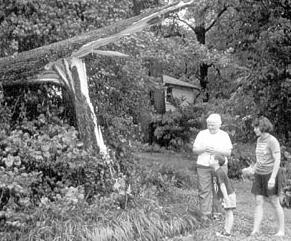
"More than the usual late summer afternoon thunderstorm, the 'weather event' than rode roughshod through the City of Falls Church and environs Monday left one man dead from a lightning strike and over a dozen downed trees in the City alone. It all transpired in a matter of a few moments of breathtaking lightning, high winds, and a torrential downpour accompanied by golf ball sized hail shortly after 6 p.m. While over 70,000 homes in Northern Virginia and 31,000 homes in the District lost power as a result of the storm, most of Falls Church south of Broad Street went dark, and power was not restored to some areas until late the following afternoon. A testament to the high volume of water than came down, albeit sideways with the high winds, was the fact that one resident on West Westmoreland Street saw more standing water in high back yard than at any other time, he said, since he's lived there the past 10 years." See the whole story and more pictures on the web at: http://www.fcnp.com/issues/0/022/
Hampton - Dave reports that the summer ends mild and wet with rainfall nearly twice normal for August. A record low minimum 57o on 8/22. 3rd wettest August in Hampton!
Herndon - Notes from Russ: "Severe thunderstorm on the 7th brought wind gusts to 53 mph and downed 3 neighborhood Bradford Pear trees. It also dumped 1.48" of rain on us in an hour."
Lynchburg - From NWS BCB: In Lynchburg the month was cooler than normal and the 10th wettest August on record! The monthly mean temp was 2.4o below normal. Rainfall was 2.01" above the norm.
New Market - Joyce reports: "The month has been crazy. Only two days reached the low 90s. Had more storms than usual earlier in the month. Lots of foggy mornings to deal with and not as many humid days as we usually have in August. Normal rainfall but cooler than usual."
Newport News - A month of record temps here with new highs on the 7th, 8th, and 9th and new record lows on the 13th, 17th, 19th, and 22nd. 20 days recorded at least a trace of rain . (report from Gary)
Norfolk - From NWS AKQ: The monthly precip was 3.55" in excess of the norm while the average monthly temp was 0.6o below normal. Rainfall for the year through month's end was 9.03" above normal.
Portsmouth - Overall a cooler and very wet month. No new records here; however, the month was the third wettest August on record since 1976). The greatest amount was 15.06" in 1992 followed by the second greatest of 12.92" in 1990. 5 days had rainfall in excess of 1" and 9 days had between 1/2 and 2" of rain. 11 days with TS. The mean temp here was 2.6o below the norm while precip was 205% of the norm of (+5.70"). Year-to-date rainfall is 117% of the norm (+5.63"). Dominant wind direction was from the S and averaged 3.2 mph.
Richmond - According to NWS AKQ, Richmond's rainfall was 3.88" above normal while temps averaged 2.2o below normal.
Mechanicsville - Glenn reports strong thunderstorms with strong winds and sharp lightning on the 4th, 9th, and 27th.
Roanoke - "A moist August with precip falling on 15 days. Totals were 1.46" above normal while temps were 1.1 deg below the normal of 74.3 Thunder was heard on 10 days." - Notes from Wendell
Roanoke - NWS BCB notes the month was cooler than normal but rainfall was almost and inch below the norm.
Vienna - Robert notes that "August was cooler than the average and about average for precipitation. Only 2 days reached the 90 mark. Thunderstorms were frequent, occurring on 8 days. A cool low temp of 52 on the 21st."
Woodstock - Lauck reports "the coolest July in 15 years of record keeping. Precip was the 4th highest. Another wet month, with the corn as high as an elephant's eye...but the hydrologists are saying that it's just good surface moisture with little recharge of the aquifers. Modest but very regular rain has kept crops in fine condition, but done little to recharge the aquifers."
North Carolina:
Asheville - From NWS GSP: The monthly mean temp was 0.3o below normal while rainfall was 0.24" below normal. The average wind speed was 4.7 MPH.
Brevard - Bob notes: " Since away from my station from August. 30 through Sept. 5, I had to divide the interval rainfall proportionally on the basis of amounts published in the local newspaper. The interval total, 2 95", was partitioned 2.03" in August. and 0.92" in September. The 5.16" total rainfall for the month is 2.04" less than the average for the past ten years bringing the year's deficit to 13.72". Annual cumulative rainfall is currently 71% of the ten-year expectation. As far as temperature is concerned, August was not unusual and compares closely to the ten-year average. Sky cover averaged about 66% for the month.July was cool, with a 30-day cooling degree days of 261 recorded compared with a ten year July average of 331 cooling DD. Rainfall, 2.79" in July, was 64% of the 10 year average of 3.31" for July. Cumulative rainfall for the year is 11.68" below the ten year average. Average cloud cover for the month was estimated to be 64%."
Charlotte - NWS GSP reports the mean temp here was 1.8o below normal while precip was 0.47" below normal. The average wind speed was 5.2 MPH. Year-to-date precip was running 4.41" below normal.
Greensboro - - NWS RAH reports that the mean temp was 0.3o below normal while rainfall was 0.09" in excess. Record low temp was set on the 22nd when the airport reached 56o. The previous record was 57o set in 1930, 1931, and 1953.
Raleigh - Bob reports: "August weather conditions were similar to July, cool and wet. Rainfall was 0.97" above normal and for the year 2.91" above normal. The average daily temperature was 1.6o below normal. There were several weather watches and warning issued for this area in August, however no severe weather was observed at this station. Quite muggy during August; observed a 77o dew point on August 8th."
Raleigh - NWS RDU reports a record low temperature was set on the 22nd with a 53o reading. The previous record was 57o set in 1969 and 1953. A record for the most precipitation on the 1st was set when the airport recorded 2.31" surpassing the previous record of 1.61" set in 1969. Also, a record high minimum temp was set on the 7th with a 75o reading. The previous record was 74o set in 1981. the monthly mean temp was 1o below the norm while precip totals were 2.62" above the norm.
Roxboro - Merriell reports: "August was much wetter than normal. Temperatures ranged from a low of 53o to a high of 93o but averaged near normal for the month. Only 3 days of 90s were recorded. That's unusual for this area.."
Wilmington - From NWS ILM: THE AVERAGE TEMP WAS 1.2 DEGREES BELOW NORMAL. NO TEMPERATURE RECORDS WERE BROKEN OR TIED IN AUGUST. TOTAL RAINFALL WAS 1.44" INCHES ABOVE NORMAL. 54 % OF POSSIBLE SUNSHINE WAS RECEIVED IN AUGUST (NORMAL IS 62%). THE AVERAGE WIND SPEED FOR THE MONTH WAS 6.6 MPH. THE 30TH WAS THE BREEZIEST DAY WITH A DAY-LONG AVERAGE OF 10.5 MPH. BUT THE 24ND SAW BOTH THE HIGHEST 2-MINUTE WIND (44 MPH FROM THE NORTHWEST) AND THE PEAK GUST (55 MPH FROM THE NORTHWEST) AS A THUNDERSTORM PASSED.
South Carolina:
Columbia - NWS CAE reports the monthly mean temp was 0.7o in excess of the norm, just as in July. Rainfall was 2.41" below the norm and the year-to-date rainfall was 10.86" below the normal.
Charleston - "No records for August. We have a contrasts in Augusts. In August, 1999, an all time record high was set at 105 degrees on the 1st. Last month, the highest temperature was a full ten degrees cooler. There was also a total of 26 days with highs of 90 degrees or better last year, with only 12 days in 2000. Last year, August was 2.6 degrees above normal (thanks to all the 90+ degree readings), but it was slightly cooler this year, thanks to the below normal average high temperatures. August 2000 was yet another dry month by well over 2 inches. However, there were three more days in 2000 with measurable rain, and the deficit was not as great as in 1999 (-3.54"). The yearly rainfall deficit has crept back up above 6.5 inches again, though the weather pattern changed near the end of August, as a front approached from the north."
Monthly precipitation was 2.75" below normal and the mean temp was 0.3o below normal. Yearly precip to date was 6.57" below normal at month's end. --Eleanor
Editor's note: Visit the NWS Charleston Education Center which Eleanor manages at http://wchs.csc.noaa.gov/education_center.htm
Greenville-Spartanburg - The monthly temps averaged 2.1o above normal while total rainfall was 2.53" below normal. The average wind speed was 4.2 MPH. 60% of possible sunshine was recorded. - NWS GSP
Nearby Cities:
Tri-cities/Bristol area noted temps averaging 1.2o below the norm with total rainfall 0.53" above the norm. For the year, rainfall is running 1.2" above normal. - from NWS Morristown, TN
(Please
note the column denotations table below.)
TEMPERATURES / WIND / ELEMENTS
|
|
|
|
|
|
|
|
|
|
|
|
|
|
|
|
|
|
|
|
|
|
|
|
|
|
|
|
|
|
|
|
|
|
|
|
|
|
|
|
|
|
|
|
|
|
|
|
|
|
|
|
|
|
|
|
|
|
|
|
|
|
|
|
|
|
|
|
|
|
|
|
|
|
|
|
|
|
|
|
|
|
|
|
|
|
|
|
|
|
|
|
|
|
|
|
|
|
|
|
|
|
|
|
|
|
|
|
|
|
|
|
|
|
|
|
|
|
|
|
|
|
|
|
|
|
|
|
|
|
|
|
|
|
|
|
|
|
|
|
|
|
|
|
|
|
|
|
|
1600 |
||||
|
|
|
|
|
|
|
|
|
|
|
|
|
|
|
|
|
|
|
|
|
|
|
|
|
|
|
|
|
|
|
|
|
|
|
|
|
|
|
|
|
|
|
|
|
|
|
|
|
|
|
|
|
|
|
|
|
|
|
|
|
|
|
|
|
|
|
|
|
|
|
|
|
|
|
|
|
|
|
|
|
|
|
|
|
|
|
|
|
|
|
|
|
|
|
|
|
|
|
|
|
|
|
|
|
|
|
|
|
|
|
|
|
|
|
|
|
|
|
|
|
|
|
|
|
|
|
|
|
|
|
|
|
|
|
|
|
|
|
|
|
|
|
|
|
|
|
|
|
|
|
|
|
|
|
|
|
|
|
|
|
|
|
|
|
|
|
|
|
|
|
|
|
|
|
|
|
|
|
|
|
|
|
|
|
|
|
|
|
|
|
|
|
|
|
|
|
|
|
|
|
|
|
|
|
|
|
|
|
|
|
|
|
|
|
|
|
|
|
|
|
|
|
|
|
|
|
|
|
|
|
|
|
|
|
|
|
|
|
|
|
|
|
|
|
|
|
|
|
|
|
|
|
|
|
|
|
|
|
|
|
|
|
|
|
|
|
|
|
|
|
|
|
|
|
|
|
|
|
|
|
|
|
|
|
|
|
|
|
|
|
|
|
|
|
|
|
|
|
|
|
|
|
|
|
|
|
|
|
|
|
|
|
|
|
|
|
|
|
|
|
|
|
|
|
|
|
|
|
|
|
|
|
|
|
|
|
|
|
|
|
|
|
|
|
|
|
|
|
|
|
|
|
|
|
|
|
|
|
|
|
|
|
|
|
|
|
|
|
|
|
|
|
|
|
|
|
|
|
|
|
|
|
|
|
|
|
|
|
|
|
|
|
|
|
|
|
|
|
|
|
|
|
|
|
|
|
|
|
|
|
|
|
|
|
|
|
|
|
|
|
|
|
|
|
|
|
|
|
|
|
|
|
|
|
|
|
|
|
|
|
|
|
|
|
|
|
|
|
|
|
|
|
|
|
|
|
|
|
|
|
|
|
|
|
|
|
|
|
|
|
|
|
|
|
|
|
|
|
|
|
|
|
|
|
|
|
|
|
|
|
|
|
|
|
|
|
|
|
|
|
|
|
|
|
|
|
|
|
|
|
|
|
|
|
|
|
|
|
|
|
|
|
|
|
|
|
|
|
|
|
|
|
|
|
|
|
|
|
|
|
|
|
|
|
|
|
|
||
|
|
|
|
|
|
|
|
|
|
|
|
|
|
|
|
|
|
|
|
|
|
|
|
|
|
|
|
|
|
|
|
|
|
|
|
|
|
|
|
|
|
|
|
|
|
|
|
|
|
|
|
|
|
|
|
|
|
|
|
|
|
|
|
||
|
|
|
|
|
|
|
|
|
|
|
|
|
|
|
|
|
|
|
|
|
|
|
|
|
|
|
|
|
|
|
|
|
|
|
|
|
|
|
|
|
|
|
|
|
|
|
|
|
|
|
|
|
|
|
|
|
|
|
|
|
|
|
|
|
|
|
|
|
|
|
|
|
|
|
|
|
|
|
|
|
|
|
|
|
|
|
|
|
|
|
|
|
|
|
|
|
|
|
|
|
|
|
|||||||
|
|
|
|
|
|
|
|
|
|
|
|
|
|
|
|
|
|
|
|
|
|
|
|
|
|
|
|
|
|
|
|
|
|
|
|
||||||||
|
|
|
|
|
|
|
|
|
|
|
|
|
|
||||||||
|
|
|
|
|
|
|
|
|
|
|
|
|
|
|
|
|
|
|
|
|
|
|
|
|
|
|
|
|
|
|
|
|
|
|
|
|
|
|
|
|
|
|
|
|
|
|
|
|
|
|
|
|
|
|
|
|
|
|
|
|
|
|
|
|
|
|
|
|
|
|
|
|
|
|
|
|
|
|
|
|
|
|
|
|
|
|
|
(Please
note the column denotations table below.)
PRECIPITATION / BAROMETRIC PRESSURE
|
|
|
|
|
|
|
|
|
|
|
|
|
|
|
|
|
|
|
|
|
|
|
|
|
|
|
|
|
|
|
|
|
|
|
|
|
|
|
|
||
|
|
|
|
|
|
|
|
|
|
|
|
|
|
|
|
|
|
|
|
|
|
|
|
|
|
|
|
|
|
|
|
|
|
|
|
|
|
|
|
|
|
|
|
|
|
|
|
|
|
|
|
|
|
|
|
|
|
|
|
|||
|
|
|
|
|
|
|
|
|
|
|
|
|
|
|
|
|
|
|||
|
|
|
|
|
|
|
|
|
|
|
|
|
|
|
|
|
|
|
|
1600 |
|
|
|
|
|
|
|
|
|
|
|
|
|
|
|
|
|
|
|
|
|
|
|
|
|
|
|
|
|
|
|
|
|
|
|
|
|
|
|
|
|
|
|
|
|
|
|
|
|
|
|
|
|
|
|
|
|
|
|
|
|
|
|
|
|
|
|
|
|
|
|
|
|
|
|
|
|
|
|
|
|
|
|
|
|
|
|
|
|
|
|
|
|
|
|
|
|
|
|
|
|
|
|
|
|
|
|
|
|
|
|
|
|
|
|
|
|
|
|
|
|
|
|
|
|
|
|
|
|
|
|
|
|
|
|
|
|
|
|
|
|
|
|
|
|
||
|
|
|
|
|
|
|
|
|
|
|
|
|
|
|
|
|
|
|
|
|
|
|
|
|
|
|
|
|
|
|
|
|
|
|
|
|
|||||
|
|
|
|
|
|
|
|
|
|
|
|
|
|
|
|
|
|
|
|
|
|
|
|
|
|
|
|
|
|
|
|
|
|
|
|
|
|
|
|
|
|
|
|
|
|
|
|
|
|
|
|
|
|
|
|
|
||||||
|
|
|
|
|
|
|
|
|
|
|
|
|
|
|
|
|
|
|
|
|
|
|
|
|
|
|
|
|
|
|
|
|
|
|
|
|
|
|
|||
|
|
|
|
|
|
|
|
|
|
|
|
|
|
|
||||||
|
|
|
|
|
|
|
|
|
|
|
|
|
|
|
|
|
|
|
|
|
|
|
|
|
|
|
|
|
|
|
|
|
|
|
|
|
|
|
|
|
|
|
|
|
|
|
|
|
|
|
|
|
|
|
|
|
|
|
|
|
|
|
|
|
|
|
|
|
|
|
|
|
|
|
|
|
|
|
|
|
|
|
|
|
|
|
|
|
|
|
|
|
|
|
|
|
|
|
|
|
|
|
||
|
|
|
|
|
|
|
|
|
|
|
|
|
|
|
|
|
|
|
|
|
|
|
|
|
|
|
|
|
|
|
|
|
|
|
|
|
|
|
|
|
|
|
|
|
|
|
|
|
|
|
|
|
|
|
|
|
|
|
|
|
|
|
|
|
|
|
|
|
|
|
|
|
|
|
|
|
|
|
|
|
|
||
|
|
|
|
|
|
|
|
|
|
|
|
|
|
|
|
|
||||
|
|
|
|
|
|
|
|
|
|
|
|
|
|
|
|
|
|
|
|
|
|
|
|
|
|
|
|
|
|
|
|
|
|
|
|
|
|
|
|
|
|
|
|
|
|
|
|
|
|
|
|
|
|
|
|
|
|
|
|
|
||
|
|
|
|
|
|
|
|
|
|
|
|
|
|
|
|
|
|
|
|
|
|
|
|
|
|
|
|
|
|
|
|
|
|
|
|
|
|
|
|
|
|
|
|
|
|
|
|
|
|
|
|
|
|
|
|
|
|
|
|
|
|
|
|
|
|
|
|
|
|
|
|
|
|
|
|
|
|
|
|
|
|
|
|
|
|
|
|
|
|
|
|
|
|
|
|
|
|
|
|
|
|
|
|
|
|
|
|
|
|
|
|
|
|
|
|
|
|
|
|
|
|
|
|
||
|
|
|
|
|
|
|
|
|
|
|
|
|
|
|
|
|
|
|
|
|
|
|
|
|
|
|
|
|
|
|
|
|
|
|
|
|
|||||
|
|
|
|
|
|
|
|
|
|
|
|
|
|
|
|
|
|
|
|
|
|
|
|
|
|
|
|
|
|
|
|
|
|
|
|
|
|
|
|
|
|
|
|
|
|
|
|
|
|
|
|
|
|
|
|
|
|
|
|
|
|
|
COLUMN DENOTATIONS:
| A maximum mean temperature | T total precipitation (inches) |
| B minimum mean temperature | U maximum calendar day precipitation (inches) |
| C monthly mean temperature | U1 date of maximum calendar day precipitation |
| D maximum temperature | V date(s) of maximum daily precipitation |
| E date(s) of maximum temperature | V1 maximum 24-hour precip. & date(s) |
| F minimum temperature | W number of days with precip. >= .01" |
| G date(s) of minimum temperature | X number of days with precip. >= 1.0" |
| H days with maximum temperature >=90 | Y year-to-date precipitation (inches) |
| I days with maximum temperature <=32 | Z maximum calendar day snowfall (inches) |
| J days with minimum temperature <=32 | 1 date of maximum calendar day snowfall (inches) |
| K days with minimum temperature <= 0 | 2 number of days with snowfall |
| L peak wind gust (miles per hour) | 3 number of days with snowfall >= 1.0" |
| M direction of peak wind gust | 4 total snowfall for month (inches) |
| N date(s) of peak wind gust | 5 total snowfall for 1999-2000 season (inches) |
| O number of days with thunder | 6 maximum barometric pressure (inches) |
| P number of days with hail | 6A date of maximum barometric pressure |
| Q number of days with glaze | 7 minimum barometric pressure (inches) |
| R number of days with ice pellets | 7A date of minimum barometric pressure |
| R1 number of days with dense fog | (i) incomplete data |
| S local observation time for temps/precipitation | (M) Missing, if listed in data table |
| ~ "about" | E estimated |
| + additional indeterminate number of days | NR not recorded |
STATION / LOCATION (MILES & DIRECTION FROM MAIN POST OFFICE) / OBSERVER / YEAR RECORDS BEGAN / EMAIL ADDRESS:
| ANN Annandale, VA 1 3/4 ENE - Lowell Koontz 12/90 wwkoontz@bellatlantic.net | ROA Roanoke, VA Webmaster (Blacksburg): William.Perry@noaa.gov |
| DCA Arlington, VA NWS Webmaster (Sterling): james.decarufel@noaa.gov | ROK Roanoke, VA 6SW Wendell Prillaman 4/76 |
| BCB Blacksburg, VA NWS Webmaster: William.Perry@noaa.gov | VNA Vienna, VA Robert Boott, 1.5SW Robert.Boott@tma.osd.mil |
| BRI Bridgewater, VA Clayton Towers Ctowers@rica.net | AKQ Wakefield, VA NWS Webmaster: Hugh.Cobb@noaa.gov |
| CEN Centreville, VA Paul Bassett 1985 pbassett@sitestar.net | WSH Washington, VA David Yowell runamok@runamok.com |
| CHO Charlottesville, VA 3N John Stewart (Rappahannock County) - 1/91 - Inactive | WEE Weems, VA 3WNW Francis J. Socey |
| IAD Dulles International Airport Webmaster (Sterling): james.decarufel@noaa.gov | WOO Woodstock, VA 5NW Lauck Walton - 12/1/85 jwalton@shentel.net |
| FCH Falls Church, VA Erica Page - 3/7/94 ERICA96661@aol.com | AVL Asheville, NC NWS NWS GSP: bryan.mcavoy@noaa.gov |
| FRB Fredericksburg, VA 7SW Ken McKneely mckneelys@email.msn.com | BRE Brevard, NC 1SE Bob Keehn 1/1/90 Bob_Keehn@citcom.net |
| HAM Hampton, VA 5NE Dave Kessel 1989 david64@visi.net | CLT Charlotte, NC NWS NWS GSP: bryan.mcavoy@noaa.gov |
| HER Herndon, VA R.M. Beall P- 10/76 T- 1/91 beall47@earthlink.net | GSO Greensboro, NC NWS Webmaster (Raleigh/RAH): Richard.Jones@noaa.gov |
| HRN Herndon, VA 4SW Russ Topping - 1985 rtopping@erols.com | RAL Raleigh, NC 7NNW Bob Woodson - 6/1/93 kf4mmm@qsl.net |
| LKU Louisa, VA 1N Joseph Bowers 1944 - NWS ID 44-5050-02 jmbiii@earthlink.net | RDU Raleigh-Durham, NC NWS Webmaster: Richard.Jones@noaa.gov |
| LOU Louisa, VA 6S John Bullock (about 1970) | LUM Lumberton, NC FAA Lumberton 34o 37'N 79o 04'W |
| LYH Lynchburg, VA NWS Webmaster (Blacksburg): William.Perry@noaa.gov | ROX Roxboro, NC 2SE Merriell A. Jay 1/93 |
| NEW Newmarket, VA 2W Joyce Winfree joywood@shentel.net | ILM Wilmington, NC NWS nwsilm@wilmington.net |
| NPN Newport News, VA 7N Gary Leonard - 6/91 GaryMLeonard@aol.com | CHS Charleston,
SC NWS, courtesy of Eleanor Vallier-Talbot
Eleanor.Vallier-Talbot@noaa.gov evaltal@wpmedia.com Webmaster Contents CHS: Theodore.Rodgers@noaa.gov |
| NOR Norfolk, VA 3NE Jim Fentress 6/1/77 | CAE Columbia, SC NWS caewx@noaa.gov |
| OGB Orangeburg, SC NWS caewx@noaa.gov | |
| ORF Norfolk, VA 5NE NWS 1871 Webmaster (Wakefield): Hugh.Cobb@noaa.gov | GSP Greenville-Spartanburg, SC NWS bryan.mcavoy@noaa.gov |
| POR Portsmouth, VA 3S Bill Trotter - 7/1/76 pwrs@pilot.infi.net | RUB Ruby, SC 3 NW Franklin Hancock |
| MEC Mechanicsville, VA Glen Martin 11/19/91 | FLO Florence, SC nwsilm@wilmington.net |
| RMD Richmond, VA Roy Britt 8/22/83 | CRE North Myrtle Beach, SC nwsilm@wilmington.net |
| RIC Richmond, VA NWS | TRI Tri-cities/Bristol, TN NWS Webmaster (Morristown):W-Mrx.Webmaster@noaa.gov |
| CHW Canaan Heights, WV Dave Lesher wxdave@boo.net |