http://www.genserva.com/acon
SUMMARY OF CLIMATOLOGICAL DATA
SUMMARY OF CLIMATOLOGICAL DATA
For many reporting stations, average temperatures for the month of December 2012 were higher than those of November 2012! Across the three-state region temperatures averaged between 5.1 and 5.4 degrees above normal while rainfall totals were just below average for Virginia and about 1.2" to 1.5" for the Carolinas.
THE NOAA RESOURCES PAGE (from CoCoRaHS) The National Oceanic and Atmospheric Administration (NOAA) has many exciting informative resources available for the public to view and learn about our oceans and atmosphere. CoCoRaHS in partnership with NOAA will continue to strive to bring you the latest products and information as they become available. During the year NOAA runs a series of weather awareness and preparedness weeks providing important information on a variety of weather related subjects. These include: Severe Weather Preparedness Week, Flood Awareness Week and Lightning Safety Awareness Week just to name a few. Visit the NOAA Resources page to see this year's schedule. To learn more about NOAA Resources listed on the CoCoRaHS Web site click on the NOAA logo on the left side of our home page: www.cocorahs.org or click here: “NOAA Resources” http://www.cocorahs.org/Content.aspx?page=noaa
WHAT "TYPE" OF PRECIPATION IS FALLING BY YOU? (from CoCoRaHS) NOAA's NSSL appreciates your help! NOAA's National Severe Storms Laboratory (NSSL) is located in Norman, Oklahoma. They study severe and hazardous weather processes and develop tools to help National Weather Service forecasters, and federal, university and private sector partners use weather information more effectively. NSSL has launched its iPhone and Android apps to collect precipitation reports from the public. The NOAA National Severe Storms Laboratory, in partnership with the University of Oklahoma has launched an app where users can anonymously report precipitation from their iPhone or Android through the "mobile precipitation identification near the ground "mPING" app. NSSL researchers will compare the reports with what radars detect and use the information to develop new radar and forecasting technologies and techniques to determine whether snow, rain, ice pellets, mixtures or hail is falling. NSSL hopes to build a valuable database of tens of thousands of observations from across the U.S. The apps are available on iTunes or Google Play for use on both phones and tablets. The reports can be viewed here in real-time: http://www.nssl.noaa.gov/projects/ping/display/ The lab's main PING page: http://www.nssl.noaa.gov/projects/ping/
Link for iTunes app: https://itunes.apple.com/us/app/mping/id584383400?mt=8
Link for Android app: https://play.google.com/store/apps/details?id=edu.ou.cimms.wping&feature=search_result#?t=W251bGwsMSwyLDEsImVkdS5vdS5jaW1tcy53cGluZyJd
If you have some extra time please give this a try, NSSL would really appreciate your help!
ARE YOU FAMILIAR WITH THE U.S. DROUGHT PORTAL? (from CoCoRaHS) When we think of the December holiday season, most of us don't picture a dry Christmas tree covered in dust do we? We usually think of lots of snow, but this year many places are lacking the fluffy white stuff on their trees. "Drought is one of the most costly natural disasters affecting the U.S. The National Integrated Drought Information System (NIDIS) was established in 2006 (NIDIS Act) to help begin to move society from a reactive response to drought to a proactive stance. NIDIS was envisioned to be a dynamic and accessible drought information system that provides users with the ability to determine the potential impacts of drought and the associated risks they bring, and the decision support tools needed to better prepare for and mitigate the effects of drought. In this, NIDIS forms the backbone of a national Drought Early Warning System and the U.S. Drought Portal is the public face of NIDIS on the Web." You may not realize it, but CoCoRaHS precipitation observations play an important role along with other factors in helping our friends at NIDIS determine where drought conditions exist. Especially important are those zeros when nothing falls from the sky and your comments on how the conditions are impacting you. To visit the NIDIS Website and learn more about the portal click here: NIDIS - http://www.drought.gov/drought/. Please take a few moments and share the NIDIS Portal website with others and keep up the good work by sending in your precipitation reports -- rain, snow or shine!
DROUGHT MONITOR http://droughtmonitor.unl.edu/ More information on drought can be found at NOAA's Drought Information Center http://www.drought.noaa.gov/
REMINDER All National Weather Service station data listed herein is preliminary and may be subject to change. The data has not been certified and cannot be used in legal actions. Only reports certified by the National Climatic Data Center in Asheville, NC can be used for these purposes.
|
|
|
Temperature |
Average Temperature |
Average Temperature |
Precipitation |
Precipitation |
|
|
Daville |
Blacksburg |
Norfolk (ORF) |
Blacksburg |
Wallops Island |
Bridgewater |
|
|
Elizabeth City |
Greensboro |
Beaufort |
Asheville |
Cape Hatteras |
Greensboro |
|
|
Florence Charleston |
Florence |
Charleston |
Anderson |
Greenville-Spartanburg |
Columbia |
| A | B | C | C1 | D | E | F | G | H | I | J | K | K1 | L | M | N | N1 | N2 | O | P | Q | R | R1 | CWA | TIME RECORDED | ||
| BCB | 48.10 | 29.00 | 38.50 | 4.70 | 66.0 | 3,4 | 16.00 | 23 | 0 | 1 | 21 | 0 | 81% | 54 | 300 | 22 | 4.9 | 1 | 0 | 2 | 1 | 6 | LWX | 2400 | ||
| BRI | 50.30 | 34.50 | 42.40 | 6.00 | 69.0 | 3,4 | 19.00 | 14 | 0 | 0 | 14 | 0 | 70% | 0 | 0 | 0 | 0 | 0 | LWX | 2400 | ||||||
| CHT | 51.00 | 34.40 | 42.70 | 6.10 | 71.8 | 4 | 22.10 | 14 | 0 | 0 | 13 | 0 | 78% | 26 | 290 | 21 | 0.5 | 360 | 0 | 0 | 1 | 1 | 9 | LWX | 2400 | |
| CHO | 52.90 | 35.10 | 44.00 | 6.20 | 73.0 | 4 | 22.00 | 4 | 0 | 0 | 15 | 0 | 43 | 330 | 23 | 4.7 | 0 | 0 | 0 | 1 | 7 | LWX | 2400 | |||
| DAN | 56.80 | 35.70 | 46.20 | 6.10 | 76.0 | 3 | 21.00 | 14 | 0 | 0 | 12 | 0 | 66% | 38 | 060 | 26 | 5.5 | 0 | 0 | 0 | 0 | 5 | RNK | 2400 | ||
| DCA | 52.30 | 38.40 | 45.30 | 5.60 | 72.0 | 4 | 29.00 | 23,31 | 0 | 0 | 5 | 0 | 68% | 49 | 330 | 30 | 7.8 | 0 | 0 | 0 | 1 | 3 | LWX | 2400 | ||
| IAD | 50.40 | 33.40 | 41.90 | 5.30 | 71.0 | 4 | 21.00 | 14,23 | 0 | 0 | 17 | 0 | 72% | 51 | 300 | 22 | 7.2 | 0 | 0 | 2 | 1 | 8 | LWX | 2400 | ||
| GAV | 55.71 | 36.19 | 45.95 | 6.10 | 75.0 | 4 | 22.00 | 31 | 0 | 0 | 13 | 0 | 72% | 35 | 180 | 10 | 0 | 0 | 0 | 1 | 2 | AKQ | 2400 | |||
| HDV | 51.20 | 34.50 | 42.80 | 4.70 | 73.0 | 4 | 23.00 | 23 | 0 | 0 | 14 | 0 | 77% | 19 | 360 | 27 | 090 | 0 | 0 | 0 | 2 | 3 | LWX | 2400 | ||
| LYH | 52.90 | 33.40 | 43.10 | 5.50 | 71.0 | 4 | 19.00 | 14 | 0 | 0 | 16 | 0 | 69% | 39 | 050 | 26 | 4.9 | 0 | 0 | 1 | 1 | 8 | RNK | 2400 | ||
| NPN | 56.50 | 38.00 | 47.10 | 4.20 | 74.6 | 4 | 22.40 | 31 | 0 | 0 | 9 | 0 | 38 | 270 | 21 | 2.3 | 230 | 1 | 0 | 0 | 0 | 1 | AKQ | 2400 | ||
| FHC | 56.44 | 42.36 | 49.40 | 5.30 | 72.3 | 4 | 28.70 | 31 | 0 | 0 | 1 | 0 | 74% | 31 | 140 | 21 | 2.4 | 200 | 0 | 0 | 0 | 0 | 0 | AKQ | 2400 | |
| NOR | 56.50 | 39.70 | 48.10 | 4.70 | 73.0 | 4 | 24.00 | 31 | 0 | 0 | 5 | 0 | 36 | 270 | 21 | 0 | 0 | 0 | 0 | 0 | AKQ | 2400 | ||||
| ORF | 57.70 | 41.60 | 49.70 | 5.60 | 75.0 | 4 | 25.00 | 31 | 0 | 0 | 3 | 0 | 70% | 40 | 160 | 21 | 8.2 | 0 | 0 | 0 | 0 | 0 | AKQ | 2400 | ||
| POR | 57.50 | 40.00 | 48.80 | 4.50 | 72.1 | 4 | 23.80 | 31 | 0 | 0 | 6 | 0 | 79% | 39 | 250 | 21 | 4.1 | 270 | 1 | 0 | 0 | 0 | 0 | AKQ | 2400 | |
| CTR | 55.60 | 34.60 | 44.60 | 4.20 | 73.9 | 4 | 19.90 | 31 | 0 | 0 | 15 | 0 | 77% | 25 | 250 | 21 | 0.8 | 257 | 0 | 0 | 0 | 0 | 0 | AKQ | 2400 | |
| MEC | 55.58 | 36.41 | 46.22 | 73.0 | 3,4 | 21.00 | 31 | 0 | 0 | 11 | 0 | 0 | 0 | 0 | 0 | 1 | AKQ | 2400 | ||||||||
| RIC | 56.40 | 36.90 | 46.70 | 5.70 | 75.0 | 4 | 22.00 | 31 | 0 | 0 | 11 | 0 | 70% | 71 | 210 | 5 | 6.6 | 0 | 0 | 0 | 0 | 4 | AKQ | 2400 | ||
| ROA | 53.30 | 36.00 | 44.60 | 5.60 | 73.0 | 3 | 23.00 | 14 | 0 | 0 | 9 | 0 | 64% | 54 | 290 | 21 | 6.7 | 0 | 0 | 3 | 1 | 4 | RNK | 2400 | ||
| WAL | 55.50 | 38.30 | 46.90 | 6.40 | 72.0 | 3 | 25.00 | 31 | 0 | 0 | 7 | 0 | 51 | 160 | 21 | 8.5 | 0 | 0 | 0 | 0 | 8 | AKQ | 2400 | |||
| WOO | 49.50 | 34.90 | 42.20 | 2.70 | 73.0 | 5 | 23.00 | 31 | 0 | 0 | 13 | 0 | 0 | 0 | 0 | 1 | 3 | LWX | 0800 | |||||||
| WSH | 50.00 | 34.90 | 42.30 | 2.36 | 72.0 | 1 | 25.60 | 31 | 0 | 0 | 13 | 0 | 76% | 22 | 070 | 22 | 0.6 | 050 | 0 | 0 | 0 | 4 | 0 | LWX | 2400 | |
| Averages | 53.73 | 36.28 | 44.98 | 5.12 | 72.58 | 22.61 | 0.0 | 0.0 | 11.0 | 0.0 | 73% | 40.1 | 4.7 | 0.1 | 3.3 | |||||||||||
| STN | A | B | C | C1 | D | E | F | G | H | I | J | K | K1 | L | M | N | N1 | N2 | O | P | Q | R | R1 | CWA | TIME RECORDED | |
| STN | A | B | C | C1 | D | E | F | G | H | I | J | K | K1 | L | M | N | N1 | N2 | O | P | Q | R | R1 | CWA | TIME RECORDED | |
| AVL | 53.6 | 33.9 | 43.8 | 4.40 | 70.0 | 3 | 23.0 | 14,23 | 0 | 0 | 13 | 0 | 71% | 47 | 320 | 21 | 6.5 | 0 | 0 | 0 | 0 | 4 | GSP | 2400 | ||
| MRH | 60.9 | 45.6 | 53.3 | 4.90 | 71.0 | 9 | 30.0 | 23 | 0 | 0 | 2 | 0 | 53 | 180 | 26 | 8.9 | 0 | 0 | 0 | 0 | 5 | MHX | 2400 | |||
| CLT | 58.4 | 39.4 | 48.9 | 6.50 | 74.0 | 4 | 21.0 | 23 | 0 | 0 | 7 | 0 | 68% | 36 | 290 | 21 | 5.7 | 0 | 0 | 0 | 0 | 5 | GSP | 2400 | ||
| ECG | 62.1 | 42.7 | 52.4 | 8.00 | 77.0 | 4 | 28.0 | 31 | 0 | 0 | 5 | 0 | 69% | 59 | 210 | 16 | 8.4 | 0 | 0 | 0 | 0 | 6 | AKQ | 2400 | ||
| FAY | 61.7 | 41.4 | 51.6 | 6.20 | 75.0 | 3 | 23.0 | 31 | 0 | 0 | 7 | 0 | 70% | 44 | 260 | 21 | 7.0 | 1 | 0 | 0 | 0 | 7 | RAH | 2400 | ||
| GSO | 55.7 | 37.9 | 46.8 | 5.50 | 73.0 | 3 | 22.0 | 23 | 0 | 0 | 8 | 0 | 66% | 43 | 230 | 20 | 7.4 | 0 | 0 | 0 | 0 | 3 | RAH | 2400 | ||
| HSE | 60.3 | 47.0 | 53.6 | 4.30 | 71.0 | 11 | 35.0 | 15,28 | 0 | 0 | 0 | 0 | 78% | 49 | 210 | 26 | 8.9 | 0 | 0 | 0 | 0 | 5 | MHX | 2400 | ||
| HKY | 55.6 | 37.4 | 46.5 | 5.40 | 73.0 | 3,4 | 25.0 | 23 | 0 | 0 | 8 | 0 | 25 | 330 | 21 | 4.1 | 0 | 0 | 0 | 0 | 5 | GSP | 2400 | |||
| LBT | 61.6 | 41.1 | 51.4 | 5.20 | 75.0 | 3,9 | 26.0 | 23,31 | 0 | 0 | 7 | 0 | 74% | 43 | 270 | 21 | 5.6 | 1 | 0 | 0 | 0 | 11 | ILM | 2400 | ||
| EWN | 62.4 | 42.1 | 52.2 | 5.40 | 76.0 | 4,9 | 25.0 | 31 | 0 | 0 | 5 | 0 | 74% | 37 | 270 | 26 | 6.0 | 1 | 0 | 0 | 0 | 5 | MHX | 2400 | ||
| RDU | 58.9 | 39.7 | 49.3 | 5.80 | 76.0 | 3 | 25.0 | 23,31 | 0 | 0 | 7 | 0 | 68% | 44 | 170 | 20 | 5.9 | 2 | 0 | 0 | 0 | 1 | RAH | 2400 | ||
| RAL | 54.3 | 39.0 | 46.7 | 3.20 | 71.0 | 10 | 24.0 | 23,31 | 0 | 0 | 9 | 0 | 28 | 10,27 | 0 | 0 | 0 | 0 | 0 | RAH | 2400 | |||||
| ROX | 55.9 | 38.8 | 47.6 | 5.10 | 75.0 | 3 | 24.0 | 14 | 0 | 0 | 8 | 0 | 74% | 40 | 270 | 21 | 180 | 0 | 0 | 0 | 0 | 2 | RAH | 2400 | ||
| ILM | 63.4 | 43.0 | 53.2 | 4.60 | 76.0 | 3 | 25.0 | 31 | 0 | 0 | 4 | 0 | 74% | 46 | 260 | 21 | 6.8 | 1 | 0 | 0 | 0 | 6 | ILM | 2400 | ||
| Averages | 58.9 | 40.6 | 49.8 | 5.32 | 73.8 | 25.4 | 0.0 | 0.0 | 6.4 | 0.0 | 71% | 42.4 | 6.8 | 0.4 | 4.6 | |||||||||||
| STN | A | B | C | C1 | D | E | F | G | H | I | J | K | K1 | L | M | N | N1 | N2 | O | P | Q | R | R1 | CWA | TIME RECORDED | |
| STN | A | B | C | C1 | D | E | F | G | H | I | J | K | K1 | L | M | N | N1 | N2 | O | P | Q | R | R1 | CWA | TIME RECORDED | |
| AND | 58.9 | 39.7 | 49.3 | 5.6 | 73 | 3,4 | 25 | 31 | 0 | 0 | 6 | 0 | 44 | 260,290 | 20,21 | 5.7 | 1 | 0 | 0 | 0 | 5 | GSP | 2400 | |||
| CAE | 63.2 | 41.9 | 52.5 | 5.8 | 76 | 3,5 | 26 | 23,31 | 0 | 0 | 6 | 0 | 68% | 51 | 260 | 20 | 5.6 | 1 | 0 | 0 | 0 | 4 | CAE | 2400 | ||
| CRE | 62.8 | 43.3 | 53.0 | 4.2 | 76 | 5 | 25 | 31 | 0 | 0 | 4 | 0 | 77% | 43 | 210 | 26 | 6.0 | 1 | 0 | 0 | 0 | 9 | ILM | 2400 | ||
| CHS | 66.1 | 44.6 | 55.4 | 4.6 | 79 | 3,9 | 26 | 31 | 0 | 0 | 3 | 0 | 44 | 210 | 26 | 6.8 | 2 | 0 | 0 | 0 | 2 | CHS | 2400 | |||
| FLO | 64.7 | 43.9 | 54.3 | 7.2 | 79 | 3 | 23 | 31 | 0 | 0 | 4 | 0 | 67% | 44 | 250 | 21 | 6.3 | 0 | 0 | 0 | 0 | 5 | ILM | 2400 | ||
| GSP | 58.7 | 40.4 | 49.6 | 5.6 | 73 | 3,4 | 27 | 22,31 | 0 | 0 | 8 | 0 | 68% | 37 | 270 | 21 | 6.1 | 0 | 0 | 0 | 0 | 3 | GSP | 2400 | ||
| OGB | 63.4 | 42.6 | 53.0 | 5.1 | 76 | 3,5 | 27 | 23,31 | 0 | 0 | 4 | 0 | 43 | 280 | 21 | 5.2 | 0 | 0 | 0 | 0 | 7 | CAE | 2400 | |||
| Averages | 62.5 | 42.3 | 52.4 | 5.4 | 76.0 | 25.6 | 0.0 | 0.0 | 5.0 | 0.0 | 70% | 43.7 | 6.0 | 0.7 | 5.0 | |||||||||||
| STN | A | B | C | C1 | D | E | F | G | H | I | J | K | K1 | L | M | N | N1 | N2 | O | P | Q | R | R1 | CWA | TIME RECORDED | |
| STN | A | B | C | C1 | D | E | F | G | H | I | J | K | K1 | L | M | N | N1 | N2 | O | P | Q | R | R1 | CWA | TIME RECORDED | |
| TRI | 52.7 | 32.6 | 42.7 | 4.9 | 71 | 9 | 18 | 23 | 0 | 0 | 17 | 0 | 44 | 250 | 20 | 3.8 | 0 | 0 | 0 | 0 | 4 | MRX | 2400 | |||
| DAV | 39.3 | 28.1 | 33.7 | 60 | 5 | 15 | 23,31 | 0 | 10 | 20 | 0 | PBX | 2400 | |||||||||||||
| STN | T | T1 | U | U1 | V | V1 | W | X | Y | Z | 1 | 2 | 3 | 4 | 5 | 6 | 6A | 7 | 7A | 8 | CWA | TIME RECORDED | ||||
| BCB | 2.41 | -0.54 | 1.01 | 26 | 1.01 | 26 | 9 | 1 | 36.53 | 1.5 | 26 | 8 | 1 | 1.9 | 1.9 | RNK | 2400 | |||||||||
| BRI | 1.18 | -1.63 | 0.15 | 24 | 8 | 0 | 27.74 | 2.0 | 26 | 3 | 5.0 | 5.0 | 30.310 | 13 | 29.510 | 18 | 29.950 | LWX | 2400 | |||||||
| CHT | 2.91 | -0.05 | 1.30 | 26 | 1.31 | 26-27 | 12 | 1 | 38.69 | 0.9 | 26 | 2 | 0 | 1.2 | 1.2 | 30.479 | 13 | 29.291 | 21 | 30.032 | LWX | 2400 | ||||
| CHO | 1.58 | -1.57 | 0.90 | 20 | 0.96 | 20-21 | 10 | 0 | 35.31 | 29.260 | 21 | LWX | 2400 | |||||||||||||
| DAN | 2.46 | -0.81 | 1.07 | 26 | 1.07 | 26 | 11 | 1 | 28.84 | 0.0 | 0.0 | 30.420 | 13 | 29.420 | 20 | RNK | 2400 | |||||||||
| DCA | 3.03 | -0.02 | 1.42 | 26 | 1.44 | 26-27 | 13 | 1 | 32.45 | 0.2 | 26 | 0 | 3 | 0.2 | 0.2 | 29.260 | 21 | LWX | 2400 | |||||||
| IAD | 2.87 | -0.09 | 1.41 | 26 | 1.42 | 26-27 | 11 | 1 | 35.80 | 1.1 | 26 | 1 | 3 | 2.2 | 2.2 | 29.260 | 21 | LWX | 2400 | |||||||
| GAV | 3.64 | -0.03 | 1.36 | 26 | 1.36 | 26 | 14 | 1 | 34.12 | T | 29 | 1 | 0 | T | T | 30.430 | 13 | 29.320 | 21 | 30.020 | AKQ | 2400 | ||||
| HDV | 3.53 | 0.25 | 1.81 | 26 | 12 | 1 | 37.32 | 1.0 | 26 | 4 | 1 | 1.3 | 1.3 | 30.460 | 13 | 29.270 | 21 | AKQ | 2400 | |||||||
| LYH | 2.65 | -0.59 | 1.00 | 26 | 1.00 | 26 | 9 | 1 | 29.78 | T | 21,26,29 | 3 | 0 | T | T | 30.460 | 13 | 29.430 | 21 | RNK | 2400 | |||||
| NPN | 3.79 | 0.10 | 1.96 | 26 | 1.96 | 26 | 10 | 1 | 73.08 | 0.0 | 0.0 | 30.420 | 1 | 29.310 | 21 | AKQ | 2400 | |||||||||
| FHC | 4.26 | 0.86 | 2.14 | 26 | 2.14 | 26 | 10 | 1 | 64.28 | 0.0 | 0.0 | 30.418 | 1 | 29.356 | 21 | 30.049 | AKQ | 2400 | ||||||||
| NOR | 4.19 | 0.79 | 2.10 | 26 | 2.10 | 26 | 11 | 1 | 54.46 | 0.0 | 0.0 | AKQ | 2400 | |||||||||||||
| ORF | 4.48 | 1.22 | 2.53 | 26 | 2.53 | 26 | 11 | 1 | 48.35 | 0.0 | 0.0 | 30.420 | 1 | 29.330 | 21 | AKQ | 2400 | |||||||||
| POR | 4.19 | 0.94 | 2.16 | 26 | 2.16 | 26 | 13 | 1 | 67.52 | 0.0 | 0.0 | 30.420 | 1 | 29.350 | 21 | 30.043 | AKQ | 2400 | ||||||||
| CTR | 2.70 | -1.29 | 1.03 | 26 | 1.04 | 26-27 | 15 | 1 | 34.01 | 0.0 | 0.0 | 30.390 | 13 | 29.320 | 21 | 30.010 | AKQ | 2400 | ||||||||
| MEC | 3.00 | 1.28 | 13 | 1.29 | 26-27 | 8 | 1 | 38.23 | 0.0 | 0.0 | 30.180 | 12,15 | 29.260 | 26 | 29.830 | AKQ | 2400 | |||||||||
| RIC | 2.83 | -0.43 | 1.32 | 26 | 1.36 | 26 | 10 | 1 | 36.52 | 0.0 | 0.0 | 30.440 | 13 | 29.340 | 21 | AKQ | 2400 | |||||||||
| ROA | 2.58 | -0.36 | 1.20 | 26 | 1.20 | 26 | 7 | 1 | 32.91 | 0.3 | 26 | 5 | 0 | 0.3 | 0.3 | 30.480 | 13 | 29.470 | 21 | RNK | 2400 | |||||
| WAL | 3.85 | 0.42 | 2.33 | 26 | 2.33 | 26 | 9 | 1 | 49.03 | 0.0 | 0.0 | 30.340 | 31 | 30.270 | 21 | AKQ | 2400 | |||||||||
| WOO | 2.26 | -0.46 | 0.56 | 23-27 | 14 | 0 | 38.98 | 2.2 | 26-27 | 5 | 4 | 6.5 | 6.5 | 30.760 | 13 | 30.020 | 18 | LWX | 0800 | |||||||
| WSH | 3.15 | -0.36 | 1.25 | 26 | 1.25 | 26 | 9 | 1 | 38.42 | 2.0 | 26 | 6 | 2 | 3.5 | 3.5 | 30.540 | 13 | 29.360 | 21 | LWX | 2400 | |||||
| Averages | 3.07 | -0.17 | 1.46 | 1.47 | 10.7 | 0.9 | 41.47 | 0.53 | 1.1 | 1.1 | 30.433 | 29.420 | 29.991 | |||||||||||||
| STN | T | T1 | U | U1 | V | V1 | W | X | Y | Z | 1 | 2 | 3 | 4 | 5 | 6 | 6A | 7 | 7A | 8 | CWA | TIME RECORDED | ||||
| STN | T | T1 | U | U1 | V | V1 | W | X | Y | Z | 1 | 2 | 3 | 4 | 5 | 6 | 6A | 7 | 7A | 8 | CWA | TIME RECORDED | ||||
| AVL | 4.38 | 0.79 | 1.83 | 26 | 1.94 | 25-26 | 12 | 1 | 40.00 | T | 21,29,30 | 3 | 0 | T | T | 30.440 | 30 | 29.430 | 26 | GSP | 2400 | |||||
| MRH | 5.11 | 1.59 | 1.46 | 26 | 1.46 | 26 | 13 | 2 | 44.60 | 0.0 | 0.0 | 30.420 | 2 | 29.450 | 26 | MHX | 2400 | |||||||||
| CLT | 3.84 | 0.59 | 1.72 | 26 | 1.72 | 26 | 10 | 1 | 32.02 | 0.0 | 0.0 | 30.410 | 13 | 29.450 | 26 | GSP | 2400 | |||||||||
| ECG | 3.85 | 1.29 | 1.08 | 26 | 1.08 | 26 | 6 | 0 | 47.77 | 0.0 | 0.0 | 30.430 | 1 | 29.370 | 21 | AKQ | 2400 | |||||||||
| FAY | 3.90 | 1.25 | 0.95 | 17 | 0.98 | 16-17 | 12 | 0 | 40.60 | 0.0 | 0.0 | 29.470 | 26 | RAH | 2400 | |||||||||||
| GSO | 2.72 | -0.26 | 1.19 | 26 | 1.19 | 26 | 9 | 1 | 36.78 | 0.0 | 0.0 | 29.470 | 26 | RAH | 2400 | |||||||||||
| HSE | 6.51 | 2.24 | 1.79 | 26 | 1.79 | 25-26 | 12 | 2 | 57.76 | 0.0 | 0.0 | 29.440 | 21 | MHX | 2400 | |||||||||||
| HKY | 4.96 | 1.26 | 2.20 | 26 | 2.21 | 25-26 | 10 | 1 | 39.91 | 30.380 | 1 | 29.450 | 26 | GSP | 2400 | |||||||||||
| LBT | 4.35 | 1.46 | 1.55 | 26 | 1.55 | 26 | 9 | 1 | 42.33 | 30.420 | 30 | 29.430 | 26 | ILM | 2400 | |||||||||||
| EWN | 4.94 | 1.54 | 1.41 | 26 | 1.41 | 26 | 15 | 1 | 52.61 | 0.0 | 0.0 | 30.430 | 2 | 29.450 | 26 | MHX | 2400 | |||||||||
| RDU | 2.94 | -0.13 | 1.41 | 26 | 1.42 | 25-26 | 12 | 1 | 48.62 | 0.0 | 0.0 | 29.470 | 26 | RAH | 2400 | |||||||||||
| RAL | 3.29 | 0.22 | 0.48 | 20,21 | 13 | 0 | 43.91 | 0.0 | 0.0 | 30.410 | 1 | 29.480 | 21 | RAH | 2400 | |||||||||||
| ROX | 3.36 | 0.00 | 1.50 | 26 | 1.25 | 26 | 9 | 1 | 42.38 | T | 21 | 1 | 0 | T | T | 30.430 | 13 | 29.460 | 20 | 30.060 | RAH | 2400 | ||||
| ILM | 4.60 | 0.98 | 1.83 | 26 | 1.84 | 25-26 | 14 | 2 | 49.00 | 0.0 | 0.0 | 30.420 | 31 | 29.470 | 26 | ILM | 2400 | |||||||||
| Averages | 4.20 | 0.92 | 1.53 | 1.45 | 11.14 | 1.00 | 44.16 | 0.0 | 0.0 | 30.419 | 29.449 | |||||||||||||||
| STN | T | T1 | U | U1 | V | V1 | W | X | Y | Z | 1 | 2 | 3 | 4 | 5 | 6 | 6A | 7 | 7A | 8 | CWA | TIME RECORDED | ||||
| STN | T | T1 | U | U1 | V | V1 | W | X | Y | Z | 1 | 2 | 3 | 4 | 5 | 6 | 6A | 7 | 7A | 8 | CWA | TIME RECORDED | ||||
| AND | 4.57 | 0.46 | 1.57 | 26 | 1.57 | 26 | 11 | 1 | 36.62 | 30.410 | 31 | 29.490 | 26 | GSP | 2400 | |||||||||||
| CAE | 3.51 | 0.29 | 0.69 | 26,29 | 0.88 | 12-13 | 9 | 0 | 40.48 | 0.0 | 0.0 | 30.400 | 31 | 29.500 | 26 | CAE | 2400 | |||||||||
| CRE | 3.73 | 0.27 | 1.32 | 26 | 1.43 | 25-26 | 12 | 1 | 37.42 | 30.450 | 31 | 29.470 | 26 | ILM | 2400 | |||||||||||
| CHS | 3.56 | 0.45 | 0.82 | 29 | 1.41 | 25-26 | 8 | 0 | 42.65 | 0.0 | 0.0 | 30.450 | 31 | 29.540 | 26 | CHS | 2400 | |||||||||
| FLO | 4.09 | 1.08 | 0.76 | 26 | 0.91 | 12-13 | 11 | 0 | 39.40 | 30.440 | 31 | 29.450 | 26 | ILM | 2400 | |||||||||||
| GSP | 5.81 | 1.70 | 2.34 | 26 | 2.40 | 25-26 | 10 | 2 | 35.91 | 0.0 | 0.0 | 30.390 | 30 | 29.470 | 26 | GSP | 2400 | |||||||||
| OGB | 4.38 | 1.06 | 0.74 | 17 | 1.13 | 25-26 | 10 | 0 | 40.16 | 30.450 | 31 | 29.520 | 26 | CAE | 2400 | |||||||||||
| Averages | 4.24 | 0.76 | 1.18 | 1.39 | 10.1 | 0.6 | 38.95 | 0.0 | 0.0 | 30.427 | 29.491 | |||||||||||||||
| STN | T | T1 | U | U1 | V | V1 | W | X | Y | Z | 1 | 2 | 3 | 4 | 5 | 6 | 6A | 7 | 7A | 8 | CWA | TIME RECORDED | ||||
| TRI | 4.00 | 0.63 | 0.96 | 10 | 0.96 | 10 | 14 | 0 | 46.15 | 0.5 | 21 | 6 | 0 | 0.6 | 0.6 | 30.450 | 30 | 29.4 | 26 | MRX | 2400 | |||||
| DAV | 7.71 | 1.26 | 27 | 23 | 1 | 53.63 | 7.3 | 22 | 13 | 8 | 29.6 | 69.7 | PBX | 2400 | ||||||||||||
| Averages | ||||||||||||||||||||||||||
| STN | T | T1 | U | U1 | V | V1 | W | X | Y | Z | 1 | 2 | 3 | 4 | 5 | 6 | 6A | 7 | 7A | 8 | CWA | TIME RECORDED | ||||
Virginia:
Arlington - " TEMPERATURES IN WASHINGTON THIS DECEMBER WERE WELL ABOVE NORMAL. THE MONTHLY AVERAGE TEMPERATURE OF 45.3 DEGREES WAS ALMOST SIX DEGREES ABOVE THE 1981-2010 NORMAL...AND WAS CLOSER TO THE CLIMATOLOGICAL NORMAL FOR MARCH THAN DECEMBER. THE MONTHLY AVERAGE TEMPERATURE WAS THE 6TH WARMEST ON RECORD FOR DECEMBER AND THE WARMEST SINCE 2001. THE WARMEST DECEMBERS ON RECORD WERE 1889 AND 1984...WHEN MONTHLY AVERAGE TEMPERATURES WERE BOTH 45.6 DEGREES. THE MONTHLY MINIMUM TEMPERATURE WAS 38.4 DEGREES...WHICH WAS THE WARMEST ON RECORD FOR DECEMBER. THE PREVIOUS WARMEST MONTHLY MINIMUM TEMPERATURE ON RECORD FOR DECEMBER WAS 38.0 DEGREES IN 1982. THE MINIMUM TEMPERATURE REACHED OR DROPPED BELOW 32 DEGREES ON ONLY FIVE CALENDAR DAYS THIS MONTH...WHICH IS THE LEAST NUMBER OF SUCH DAYS FOR DECEMBER ON RECORD. THE PREVIOUS LOWEST NUMBER OF DAYS OF BELOW-FREEZING MINIMUM TEMPERATURES IN DECEMBER WAS SEVEN IN 1972... 1974...1984...2007 AND 2011. TWO DAILY TEMPERATURE RECORDS WERE SET OR TIED IN DECEMBER. ON THE 3RD...A HIGH TEMPERATURE OF 71 DEGREES BROKE THE PREVIOUS DAILY RECORD OF 70 DEGREES IN 1950. ON THE 17TH...A MINIMUM TEMPERATURE OF 48 DEGREES TIED THE DAILY HIGH MINIMUM TEMPERATURE RECORD THAT WAS SET IN 1984. THE LAST TIME THE TEMPERATURE REACHED 70 DEGREES OR HIGHER IN DECEMBER WAS IN 2008. PRECIPITATION FOR THE MONTH WAS NEAR NORMAL. NEARLY HALF OF THE MONTHLY PRECIPITATION FELL ON THE 26TH...WHEN A DAILY RECORD RAINFALL OF 1.42 INCHES WAS SET...BREAKING THE PREVIOUS RECORD OF 1.31 INCHES SET IN 1943. SNOW WAS OBSERVED ON THREE DAYS THIS DECEMBER...BUT ONLY THE 26TH HAD MEASURABLE SNOWFALL /0.2 INCH/. " - [ + - ] - Notes from NWS Sterling, VABridgewater - Clayton adds: " During the last week of the month, we had 3 "mini-snowfalls" with a total of 5 inches. The temperature for the year was above normal. The precipitation was 1 inch below normal. There were 27 thunderstorms. Snowfall was much below normal. " - [ + - ]
Chantilly - Russ adds these notes: " December was warm with average precipitation. The mean monthly temperature was 42.7 deg (+6.1 deg). The mean high temperature was 51.0° (+5.0 deg) and the mean low temperature was much above normal at 34.4 deg (+7.3 deg). This was our fourth warmest December on record. A record high low temperature was tied on the 16th (43.5 deg). Precipitation was close to average at 2.91" (-0.05"). A daily record 1.30" of rain fell on the 26th. We received snow flurries on Christmas Eve day, snow on the 26th (0.9") which turned to a wintry mix (IP, FrzRn 0.2"), and snow on the 29th (0.25"). Snowfall was 2.4" below normal. Dense fog was observed on the 1st, 2nd, 9th, 10th, 16-18th, 24th, and 25th. *Please note, anemometer is currently partially obstructed from the North and East " - [ + - ]
Dulles - from NWS Sterling (KLWX): " TEMPERATURES AT DULLES WERE WELL ABOVE NORMAL THIS DECEMBER. THE MONTHLY AVERAGE TEMPERATURE OF 41.9 DEGREES WAS OVER FIVE DEGREES ABOVE THE 1981-2010 NORMAL...AND WAS TIED WITH DECEMBER 2006 FOR THE 4TH WARMEST DECEMBER ON RECORD. THE MONTHLY MINIMUM TEMPERATURE WAS 33.4 DEGREES...THE SECOND WARMEST FOR DECEMBER. ONLY 1982 WAS WARMER WITH A MONTHLY MINIMUM TEMPERATURE OF 33.7 DEGREES. NO DAILY TEMPERATURE RECORDS WERE SET AT DULLES IN DECEMBER. THE MAXIMUM TEMPERATURE REACHED 71 DEGREES ON THE 4TH. THE LAST TIME THE TEMPERATURE REACHED 70 DEGREES OR HIGHER IN DECEMBER WAS 2006. PRECIPITATION FOR THE MONTH WAS NEAR NORMAL. HALF OF THE MONTHLY PRECIPITATION FELL ON THE 26TH WHEN A DAILY RECORD RAINFALL OF 1.41 INCHES WAS SET...BREAKING THE PREVIOUS RECORD OF 1.00 INCH IN 1969. MEASURABLE SNOWFALL WAS OBSERVED ON THREE DAYS THIS DECEMBER...0.2 INCH ON THE 24TH...1.1 INCH ON THE 26TH AND 0.9 INCH ON THE 29TH. THE SNOWFALL ON THE 29TH WAS THE MOST ON RECORD FOR THAT CALENDAR DAY...BREAKING THE PREVIOUS RECORD OF 0.3 INCH IN 1993. " - [ + - ]
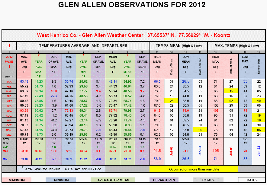
Glen Allen - Lowell adds these additional notes: " December was very warm as was December 2011 as the monthly mean temperature was 46.0 °, a +6.1 ° departure from the four year Glen Allen average. It is also interesting that December’s mean temperature was 0.5 ° warmer than November's. December had its first 75 ° day on the records at Glen Allen on December 4th and had 3 days of >= 70 ° and 11 days of >=60 °. A new record maximum dew point temperature for December of 66.3 ° occurred on the 10th. On only 13 days did the minimum reach freezing or below which was a new record for December. The lowest temperature was 22 ° occurring on the 31st; only in 2011 was this higher with a 25 ° minimum. The lowest barometric pressure of the month was 29.32 inches recorded on the 21st; the highest was 30.43 inches on December 13th. December didn’t even have a trace of snow and only a slight trace of sleet mixed with rain on the 29th at 3:35 AM. The precipitation total was near average but there was a new maximum record of 14 days with measurable precipitation in December. This was also the cloudiest December with the highest average relative humidity on record for December at Glen Allen. The 35 mph maximum wind gust on the 10th was also a new record for December at Glen Allen. (Records since 2008)
For the year 2012, click the image below to enlarge Lowell's graphic data summary. " - [ + - ]
To read Lowell's narrative summary for the year, click here.
Herndon - Randy sends these notes: " December was well above normal for temperature and slightly above for precipitation. The temperatures ranged between a high of 73 and a low of 23. We averaged 4.7 degrees above normal for the month. The low of 23 and the average low of 34.5 were the warmest for Dec in my 20 years of record keeping at this site. On the precipitation side, the month was 0.25” above normal with 3.53” measured. Most of the month’s rain came on the 26th when we received 1.81”. We finished the year with 37.32”, which is 8.64” below normal for the year. We did have our first snow of the year and measured 1.3” for the month with 1.0” coming on the 26th. We had snow on the day before Christmas and the day after Christmas; but did not have a White Christmas day. " - [ + + ]
Portsmouth - " December 2012 was the 6th Warmest December in the database to 1976. December 2012 tied with December 1977 for the 9th Wettest December IN THE DATABASE T0 1976. December's average temperature (48.8°) was 4.5° ABOVE NORMAL. An interesting fact: December's average temperature was warmer than the average temperature for November 2012. Precipitation was ABOVE NORMAL by 0.94" or 129% of normal relative to normal Decembers for the period from 1976 to 2011. Frontal passages occurred on the 5th, 7th (WARMFROPA), 11th, 18th, 21st, 25th, 26th, and 29th. Frost was recorded on the 1st, 6th, 7th, 14th, 15th, 19th, 20th, 23rd, 28th, 30th, 31st (heavy). STATION RECORDS: 16th - TEMPERATURE TIED Maximum Minimum 49° [previous 1984]; 17th - TEMPERATURE Maximum Minimum 56° [previous 51° 1992]; 21st - WIND GUST 39mph [previous 35mph 1988]; 26th - RAINFALL 2.16" [previous 1.06" 2007] - [ + + ]
Richmond - from Lowell Koontz in nearby Glen Allen: " The mean temperature for the Richmond International Airport was 46.6 ° which made December the 6th warmest in the past 115 years and the 8th warmest in the past 132 years. The lowest maximum temperature of 45 ° for December occurred on the 28th, which was the warmest December low maximum temperature on record; the previous record was 44 ° recorded in 2011. Richmond’s December minimum temperature was 22 °. Only in 7 years of the past 115 years has this been higher. Richmond’s lowest daily mean temperature for December was 34.5 °, which was the 2nd highest recorded in the past 115 years; only 2011 was higher with 36.5 °. December didn’t even have a trace of snow and this has happened only 13 times before 2012. The 30-year average snowfall for December is 2.1 inches. The 2.83 inches of precipitation for December was -0.43 inch departure and the 61st driest December of the past 115 years. The total precipitation for the year is 36.52 inches, which was a -7.08 inch deficit for 2012. " - [ + - ]
North Carolina:
Fayetteville - from NWS Raleigh RAH: " THE MINIMUM TEMPERATURE DECEMBER 10 AT FAYETTEVILLE REGIONAL AIRPORT WAS 63 DEGREES. THIS BREAKS THE PREVIOUS HIGH MINIMUM TEMPERATURE OF 60 DEGREES SET IN 2008. " - [ + + ]
Greensboro - from NWS Raleigh RAH: " THE HIGH TEMPERATURE DECEMBER 3 AT PIEDMONT TRIAD INTERNATIONAL AIRPORT WAS 73 DEGREES. THIS BREAKS THE PREVIOUS RECORD HIGH TEMPERATURE OF 72 SET IN 1970. THE DECEMBER MONTHLY AVERAGE TEMPERATURE WAS ABOVE NORMAL AT PIEDMONT TRIAD INTERNATIONAL AIRPORT. THIS ENDS FOUR CONSECUTIVE MONTHS OF BELOW NORMAL AVERAGE TEMPERATURES. THE LAST TIME FOUR CONSECUTIVE MONTHS OF BELOW NORMAL AVERAGE TEMPERATURES OCCURRED FOR THIS LOCATION WAS NOVEMBER 2002 TO FEBRUARY 2003. " - [ + - ]
Raleigh - from NWS Raleigh RAH: " THE MINIMUM TEMPERATURE DECEMBER 10 AT RALEIGH-DURHAM INTERNATIONAL AIRPORT WAS 63 DEGREES. THIS BREAKS THE PREVIOUS HIGH MINIMUM TEMPERATURE OF 61 DEGREES SET IN 2008. THE MINIMUM TEMPERATURE DECEMBER 17 AT RALEIGH-DURHAM INTERNATIONAL AIRPORT WAS 55 DEGREES. THIS BREAKS THE PREVIOUS HIGH MINIMUM TEMPERATURE OF 54 DEGREES SET IN 1937. THE DECEMBER MONTHLY AVERAGE TEMPERATURE AT RALEIGH-DURHAM INTERNATIONAL AIRPORT WAS ABOVE NORMAL. THIS ENDS FOUR CONSECUTIVE MONTHS OF BELOW NORMAL AVERAGE TEMPERATURES. THE LAST TIME THERE WERE FOUR CONSECUTIVE MONTHS OF BELOW NORMAL AVERAGE TEMPERATURES AT THIS LOCATION WAS APRIL 2003 TO JULY 2003. " - [ + - ]
Raleigh - Bob adds: " THE AVERAGE DAILY TEMPERATURE DURING DECEMBER WAS 3.2 DEGREES ABOVE NORMAL. THIS IS THE FIRST MONTH WITH ABOVE NORMAL AVERAGE TEMPERATURES SINCE JULY 2012. PRECIPITATION WAS ALSO ABOVE NORMAL BY 0.22" AND 2012 ENDED UP 2.27" ABOVE NORMAL. THERE WAS NO WINTRY OR SEVERE WEATHER DURING DECEMBER. " - [ + - ]
North Whiteville - Christopher sends this note: " I will be back up and running reliably in the near future. I had to send the sensor suite and console back to Davis Instruments for repair! The unit has been returned and data will be presented again beginning January 2013. "
Nearby Locations:
TRI-CITIES - from NWS Raleigh RAH: " Tri-Cities received 4.00 inches of precipitation in December, which was 0.63 inches above normal. It ranked as the 24th wettest December on record. Measurable precipitation occurred on 14 days, and just 5 of those days had more than one-quarter of an inch of precipitation. The heaviest precipitation fell on the 10th when 0.96 inches of precipitation was reported. The wettest December of the 74 years of observations taken at Tri-Cities was in 1961, when 6.75 inches of precipitation was recorded. Tri-Cities received an annual total of 46.05 inches of precipitation in 2012, which was 5.04 inches above normal. It ranked as the 17th wettest year on record. The wettest year was in 2003, when 65.64 inches of precipitation was recorded. The monthly-averaged temperature at Tri-Cities in December was 42.7 degrees, which was 4.9 above normal. It ranked as the 14th warmest December on record. The warmest December at Tri-Cities was in 1971, when the average temperature was 47.5 degrees. The annually averaged temperature at Tri-Cities in 2012 was 58.3 degrees, which was 2.6 degrees above normal. It tied with 1990 as the warmest year on record. " - [ + + ]
COLUMN DENOTATIONS:
| A maximum mean temperature | T total precipitation (inches)
T1 departure from normal |
| B minimum mean temperature | U maximum calendar day precipitation (inches) |
| C monthly mean temperature
C1 departure from normal |
U1 date of maximum calendar day precipitation |
| D maximum temperature | V date(s) of maximum daily precipitation |
| E date(s) of maximum temperature | V1 maximum 24-hour precip. & date(s) |
| F minimum temperature | W number of days with precip. >= .01" |
| G date(s) of minimum temperature | X number of days with precip. >= 1.0" |
| H days with maximum temperature >=90 | Y year-to-date precipitation (inches) |
| I days with maximum temperature <=32 | Z maximum calendar day snowfall (inches) |
| J days with minimum temperature <=32 | VRB Variable |
| K days with minimum temperature <= 0 | 1 date of maximum calendar day snowfall (inches) |
| K1 average relative humidity | 2 number of days with snowfall |
| L peak wind gust (miles per hour) | 3 number of days with snowfall >= 1.0" |
| M direction of peak wind gust | 4 total snowfall for month (inches) |
| N date(s) of peak wind gust | 5 total snowfall for 2012-2013 season (inches) |
| N1 average wind speed (miles per hour) | 6 maximum barometric pressure (inches) |
| N2 dominant wind direction | 6A date of maximum barometric pressure |
| O number of days with thunder | 7 minimum barometric pressure (inches) |
| P number of days with hail | 7A date of minimum barometric pressure |
| Q number of days with glaze | 8 average sea-level pressure |
| R number of days with ice pellets | STN Station |
| NR not recorded | |
| R1 number of days with dense fog [1/4 mile and less visibility] | (i) incomplete data |
| S local observation time for temps/precipitation | (M) missing, if listed in data table |
| ~ "about" | E estimated |
| + additional indeterminate number of days | CWA - NWS Office County Warning Area |

For Weather Headlines
visit the National Weather Service Homepage
or conduct a Google.com Search
http://www.weather.gov
National
Weather Service Web Sites & Current Email Addresses
Within or
Nearby the ACON VA/NC/SC Area Can Be Found At:
NWS Washington/Baltimore,
VA/MD
NWS Wakefield, VA
NWS Blacksburg, VA
NWS Raleigh, NC
NWS Newport/Morehead City, NC
NWS Wilmington, NC
NWS Greenville-Spartanburg, SC
NWS Columbia, SC
NWS Charleston, SC
NWS Morristown, TN
National Weather Service Homepages
National Climatic Data Center, Asheville, NC
STATION / LOCATION (MILES & DIRECTION FROM MAIN POST OFFICE)/OBSERVER / YEAR RECORDS BEGAN / EMAIL ADDRESS:
| AKQ Wakefield, VA NWS Wakefield Municipal Airport 36-58-53N 077-00-04W 33M | |
| DCA Arlington, VA Washington, DC, Reagan Washington National Airport 38-50-54N 077-02-03W 18M | WSH Washington, VA David Yowell runamok@runamok.com |
| BCB Blacksburg, VA NWS Virginia Tech Airport 37-13N 080-25W | |
| WOO Woodstock, VA 5NW Lauck Walton 12/1/85 jwalton@shentel.net | |
| LDY Ladysmith, VA Danny Jessee 2003 STATION CLOSED 8/31/2010 danny@dannyjessee.com | |
| BRI Bridgewater, VA Clayton Towers Ctowers19@aol.com | WAL Wallops Island, VA 37° 56'26" N 75° 27'47" W Wallops Flight Facility Airport | CEN Centreville, VA Paul Bassett 1985, 38° 50.9788' N LAT. 77° 25.6374' W LON. | Elevation 324' | m.psb@verizon.net | AVL Asheville, NC Asheville Regional Airport 35-25-55N 082-32-15W 670M |
| CHO Charlottesville, VA Charlottesville-Albemarle Airport ASOS (Rappahannock County) 38-08-18N 078-27-21W 192M | MRH Beaufort, NC Michael J. Field Airport 34-44-01N 076-39-38W 3M |
| DAN Danville, VA, Danville Regional Airport, 36-34-22N 079-20 10W 175M | CLT Charlotte, NC NWS Charlotte/Douglas International Airport 35-12-48N 080-56-55W 220M |
| IAD Dulles - Washington-Dulles International Airport 38-56-05N 077-26-51W 93M | |
| FCH Falls Church, VA Erica Page 3/7/94 Windie1970@aol.com | HKY Hickory, NC |
| HAM Hampton, VA 5NE Dave Kessel 1989 davidkessel@cox.net | ECG Elizabeth City, NC, Coast Guard Air Station 36-15-47N 076 10-58W 11M | LYH Lynchburg, VA NWS Lynchburg Regional Airport 37-19-15N 079-12-24W 295M | ILM Wilmington, NC NWS New Hanover International Airport 34-16-06N 077-54-22W 9M |
| CTR Winterpock in Chesterfield County, VA Albert Arnold 06/03 | FAY Fayetteville, NC Fayetteville Regional Airport, 34-59-22N 078-52-48W 55M |
| GSO Greensboro, NC NWS Piedmont Triad International Airport 36-05-51N 079-56-37W 275M | |
| CHT Chantilly, VA Russ Topping - 12/2006 russ.topping@gmail.com - new location December 2006 | HSE Cape Hatteras, NC Mitchell Field 35-13-56N 075-27-21W 3M |
| HDV Herndon, VA Randoplh W. Ashby, 3.3 SM South, Lat: 38.922127, Lon: -77.38015, Elev: 390'. Randolph_Ashby@Raytheon.com | LBT Lumberton, NC Lumberton Municipal Airport 34-36-26N 079-03-36W 37M |
| GAV - Glen Allen, Henrico County, VA - Lowell Koontz 8/1/08 wwkoontz@verizon.net | EWN New Bern, NC Craven County Regional Airport 36-04-03N 077-02-50W 3M |
| MON Moncure, NC Chatham County - Mac McIlwain mac.mcilwain@embarqmail.com | |
| RAL Raleigh, NC 7NNW Bob Woodson - 6/1/93 kf4mmm@qsl.net | |
| LKU Louisa, VA 1N Joseph Bowers 1944 - NWS ID 44-5050-02 STATION CLOSED | RDU Raleigh-Durham, NC Raleigh-Durham International Airport 35-52-14N 078-47-11W 130M |
| LOU Louisa, VA 6S John Bullock (about 1970) STATION CLOSED | ROX Roxboro, NC 2SE Merriell A. Jay 1/93 |
| WHI North Whiteville, NC Christopher Crawley 12/10 34.413744N / 078.751908W | |
| LYH Lynchburg, VA NWS Lynchburg Regional Airport 37-19-15N 079-12-24W 295M | ILM Wilmington, NC NWS New Hanover International Airport 34-16-06N 077-54-22W 9M |
| NEW Newmarket, VA 2W Joyce Winfree STATION CLOSED 5/31/10 joywood@shentel.net | CHS Charleston, SC NWS Charleston Air Force Base 32-53-56N 080-02-26W 13M |
| NPN Newport News, VA 7N Gary Leonard - 6/91 GaryMLeonard@aol.com | CAE Columbia, SC NWS Columbia Metropolitan Airport 33-56-31N 081-07-05W 73M |
| NOR Norfolk, VA 3NE Jim Fentress 6/1/77 | FLO Florence, SC Florence Regional Airport 34-11-16N 079-43-51W 44M |
| ORF Norfolk, VA 5NE 36-54-13N 076-11-31W 14M 1871 | GSP Greenville-Spartanburg, SC NWS Greenville-Spartanburg Airport 34-53-02N 082-13-15W 286M |
| POR Portsmouth, VA 36.81° North 76.33° West 3S Bill Trotter - 7/1/76 wxr@cox.net | CRE North Myrtle Beach, SC Grand Strand Airport 33-48-42N 078-43-26W 10M |
| MEC Mechanicsville, VA Glen Martin 11/19/91 | OGB Orangeburg, SC Orangeburg Municipal Airport 33-27-50N 080-51-13W 59M |
| FHC Norfolk, VA Fred Heutte Center 36° 54'N 76° 16'W 01/01/03 fhcgarden@cox.net | AND Anderson, SC |
| RIC Richmond, VA Richmond International Airport 37-30-40N 077-19-24W 50M | TRI Tri-cities, TN (Bristol / Johnson / Kingsport), Tri-City Regional Airport 36-28-47N 082-23-56W 474M |
| ROA Roanoke, VA Roanoke Regional Airport 37-19-01N 079-58-27W 362M | DAV Davis, WV Dave Lesher canaanwx@yahoo.com |