|
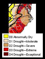
...Continued Warm & Very Dry... ...Drought at Severe to Extreme Levels...
|
|
|
...Continued Warm & Very Dry... ...Drought at Severe to Extreme Levels...
|
|
![]()
For ACON
VA/NC/SC Recent Weather News, Search CNN
http://www.cnn.com/WEATHER
|
|
|
Temperature |
Average Temperature |
Average Temperature |
Precipitation |
Precipitation |
|
|
Newport News, Norfolk (ORF,NOR), Portsmouth, Wakefield |
Bridgewater, New Market |
Portsmouth |
Blacksburg |
Portsmouth |
New Market |
|
|
Lumberton |
Brevard |
Wilmington |
Asheville |
Wilmington |
Greensboro |
|
|
Florence |
Greenville-Spartanburg |
Charleston |
Greenville-Spartanburg |
North Myrtle Beach |
Greenville-Spartanburg |
(Please
note the column denotations table below.)
TEMPERATURES / WIND / ELEMENTS
STN A B C D E F G H I J K L M N O P Q R R1 S ------------------------------------------------------------------------------ AHB 54.6 28.3 39.8 74.6 1 13.8 14 0 0 23 0 40 WNW 4 0 0 1 1 0 2400 ANN 51.43 31.07 41.25 75 1 19 5 0 0 18 0 42 NW 4 1 0 0 1 2 2400 BCB 35.9 66 1 13 5,28 40 17 2400 BRI 52.5 27.1 39.7 70 1 10 5 0 0 19 0 0 0 0 0 0 0515/1600 CEN 52.0 29.9 40.7 76 1 16 14 0 0 21 0 47 335° 11 0 0 0 1 1 1200/2400 CHO 53.1 28.9 41.0 74 1 18 14 0 0 21 0 38 270° 11 1 0 0 0 0 2400 31 190° 23 DAN 55.2 30.4 42.8 76 1 20 28 0 0 19 0 2400 DCA 52.5 32.7 42.6 77 1 21 5 0 0 16 0 52 330° 4 1 0 0 0 0 2400 IAD 51.6 26.1 38.8 75 1 14 14 0 0 23 0 46 320° 11 0 0 1 0 0 2400 FCH 51.8 30.9 41.4 77 1 19 5 0 0 19 0 47 1 1 0 0 0 0 2400 HAM 2200 HRG 50.2 25.6 37.9 71.2 1 11.8 5 0 0 22 0 26 SSW 4 0 0 0 0 0 2400 HER 50.0 29.5 39.8 73.6 1 18.3 5 0 0 21 0 31 4 1 0 0 0 2400 HRN 49.9 29.4 39.9 72.2 1 17.5 14 0 0 20 0 46 SSW 1 1 0 0 1 1 2400 LKU 53.7 24.4 39.7 76 1 12 5 0 0 24 0 34 NW 1 0 0 0 0 0 2400 LYH 52.9 28.4 40.7 74 1 18 5,12 0 0 20 0 40 11 2400 LXI 52.4 24.3 37.7 72.3 1 11.7 5 0 0 24 0 40 NNW 4 0 0 2 1 1 2400 NEW 53.68 25.00 39.34 74 1 10 5,14 0 0 22 0 48 NW 11 0 0 1700 NPN 56.6 32.4 44.5 81 1 22 5,19 0 0 16 0 43 WNW 4 0 0 0 0 1 2300 NOR 56.6 34.6 45.6 81 1 24 5 0 0 13 0 0 0 0 0 0 2400 ORF 55.6 35.7 45.7 81 1 25 5 0 0 11 0 48 250° 1 0 0 0 0 0 2400 POR 58.6 34.5 46.6 81 1 24 28 0 0 13 0 34 N 4 0 0 0 0 0 2400 MEC 59 31 45 79 1 20 5 0 0 15 0 9.8 NE 27 0 0 0 0 1 1800 RIC 55.3 30.9 42.7 79 1 19 5 0 0 21 0 48 230° 1 0 1 0 0 3 2400 RMD 2300 ROA 52.1 29.6 40.9 72 1 16 5 48 4 2400 ROK 52.8 28.6 40.7 74 1 17 28 0 0 20 0 33 NW 4 0 0 0 0 0 2200 AKQ 57.64 29.29 43.46 81 1 20 19 0 0 21 0 2400 WEE 51.4 27.2 39.3 80 1 18 5,19 0 0 18 0 40 NE 1 0 0 0 0 0 0800/2000 40 SE 11 WOO 53.1 31.8 42.5 72 1 15 5 0 0 16 0 0 0 0 1 2 0800 WSH 50.9 29.5 40.2 73.6 1 15.4 5 0 0 18 0 27 NE 11 0 0 0 0 0 2400 |
STN A B C D E F G H I J K L M N O P Q R R1 S ------------------------------------------------------------------------------ AVL 51.7 28.9 40.3 68 1 14 28 0 1 21 0 49 340° 4 0 0 0 1 1 2400 BRE 69 7 1600 CLT 56.2 32.2 44.2 72 1,26 14 28 0 0 16 0 44 320° 4 0 0 0 0 0 2400 ECG 58.8 35.3 47.1 81 1 24 19,28 0 0 13 0 53 010° 4 0 0 0 0 2 2400 GSO 53.8 31.0 42.4 72 1 18 5,28 0 0 17 0 45 220° 1 0 0 0 0 0 2400 LBT 59.1 34.4 46.8 82 1 18 28 0 0 15 0 43 310° 4 0 0 0 0 0 2400 RAL 58.2 30.6 44.4 79 1 18 28 0 0 19 0 36 1 0 0 0 0 1900 RDU 56.9 32.3 44.6 79 1 18 28 0 0 15 0 43 330° 4 0 0 0 0 0 2400 ROX 55.4 31.8 43.6 74.0 1 17.0 28 0 0 16 0 40 NW 4 0 0 0 1 0 2100 ILM 61.2 36.6 48.9 79 1 23 28 0 0 10 0 44 320° 4 0 0 0 0 2 2400 |
STN A B C D E F G H I J K L M N O P Q R R1 S ------------------------------------------------------------------------------ CAE 59.6 35.4 47.5 80 1 17 28 0 0 10 0 40 310° 4 0 0 0 0 1 2400 CHS 64.0 39.8 51.3 82 1 21 28 0 0 6 0 43 SW 20 0 0 0 0 2 2400 CRE 59.8 37.0 48.4 74 21 22 28 0 0 9 0 41 300° 4 0 0 0 0 3 2400 FLO 60.5 36.2 48.4 84 1 19 28 0 0 11 0 45 330° 4 0 0 0 0 0 2400 GSP 56.2 33.8 45.0 71 1 16 28 0 0 12 0 35 350° 4 0 0 0 4 0 2400 35 210° 26 OGB 61.1 36.9 49.0 0 0 8 0 39 260° 27 0 0 0 0 2 2400 |
STN A B C D E F G H I J K L M N O P Q R R1 S ------------------------------------------------------------------------------ TRI 50.3 26.6 38.5 66 9,10 14 5 0 1 22 0 2400 DAV 37.9 19.2 28.6 58 1 2 5 0 7 24 0 1900 |
(Please
note the column denotations table below.)
PRECIPITATION
/ BAROMETRIC PRESSURE
STN T U V V1 W X Y Z 1 2 3 4 5 6 7 S ----------------------------------------------------------------------------------------- AHB 0.41 0.16 7 0.17 7-8 4 0 1.63 T 7 0 0 T 2.5 30.488 7 29.552 26 2400 ANN 0.52 0.23 7 0.23 7 7 0 2.08 0.6 4 2 0 1.1 4.9 30.49 9, 29.59 26 2400 10,14 BCB 0.64 0.40 6 2.78 2.7 6.6 2400 BRI 0.47 0.44 7 0.44 7 2 0 1.19 1.5 7 1 1.5 8.0 30.36 29.83 0515/1600 CEN 0.41 0.18 7 0.18 7 4 0 1.54 T 7 1 0 T 3.1 30.50 9 29.54 26 2400 CHO 0.64 0.37 7 0.55 6-7 3 0 1.84 0.0 0.0 0.0 30.46 9 29.56 26 2400 DAN 0.90 0.84 7 30.46 5 29.61 26 2400 DCA 0.47 0.19 7 0.19 7 6 0 1.79 0.3 7 0 0 0.5 3.2 30.51 9 29.59 26 2400 IAD 0.47 0.18 7 0.18 7 7 0 1.69 T 4 1 0 T 2.6 30.50 9 29.57 26 2400 FCH 0.49 0.20 7 0.67 7 6 0 1.30 0.2 4 2 0 0.2 2.2 2400 HRG 0.41 0.36 7 0.38 6-7 2 0 1.42 2.5 6 2 1 2.5 8.5 30.40 9 29.61 26 2400 HAM 12.0 2200 HER 0.47 0.20 7 0.20 7 6 0 1.92 0.1E 4 2 0 0.1E 2.6 30.52 9 29.42 26 2400 HRN 0.47 0.19 7 0.19 7 7 0 1.96 0.1 4 1 0 0.1 2.4 30.475 9 29.607 26 2400 LKU 0.82 0.52 7 0.66 6-7 4 0 2.62 0.0 0.0 7.5 30.47 29.56 2400 LYH 1.04 0.81 7 0.81 6-7 3.37 0.1 1.6 30.46 14 29.61 26 2400 LXI 0.59 0.37 7 0.51 6-7 3 0 1.02 0.0 0.0 6.4 30.41 5 29.61 26 2400 NEW 0.34 0.30 7 2 0 0.84 1.0 7 1.0 7.8 30.48 14 29.78 26 1700 NPN 1.33 1.04 7 1.04 7 4 1 1.33 T 4,17 3 0 T 10.3 30.49 14 29.70 27 2300 27 NOR 1.50 1.19 7 1.19 7 5 1 6.79 0.3 27 1 0 9.0 9.0 2400 ORF 1.38 1.10 7 1.10 6-7 11 0 5.60 0.2 27 1 0 0.2 7.4 30.47 9 29.65 27 2400 POR 1.63 1.20 7 1.22 6-7 5 1 6.56 0.2 27 2 0 0.2 9.2 30.460 9 29.670 27 2400 MEC 0.87 0.87 7 0.87 7 1 0 4.19 T 4,27 0.0 8.1 30.27 9 29.43 26 1800 RIC 0.82 0.75 7 0.80 6-7 4 0 4.40 T 6,17 2 0 T 8.7 30.50 9 29.50 26 2400 RMD 2300 ROA 0.71 0.59 7 0.59 6-7 5 0 2.48 0.5 4.1 30.49 5 29.62 26 2400 ROK 0.70 0.38 7 0.61 6-7 3 0 2.65 0.1 6 3 0 0.1 4.0 30.48 9 29.67 26 2400 AKQ 1.15 1.00 7 5 1 6.37 T 4,18, T 9.0 2400 27 WEE 1.04 0.74 7 0.74 7 5.16 3.6 7 2 1 3.6 9.4 30.56 14 29.68 28 1630 WOO 0.43 0.43 6-7 6 0 1.49 1.5 7 2 0 1.6 9.6 30.81 9 30.22 27 0800 WSH 0.46 0.28 7 0.28 7 7 0 1.59 T 3 0 2.8 2.8 30.53 9 29.66 26 2400 |
STN T U V V1 W X Y Z 1 2 3 4 5 6 7 S ----------------------------------------------------------------------------------------- AVL 1.30 0.72 6 0.90 6-7 5 0 4.94 0.3 6 1 0 0.3 1.6 30.46 5 29.72 26 2400 BRE 1.80 6.19 2400 CLT 1.53 0.70 7 0.95 6-7 4 0 6.22 0.0 0.0 4.4 30.48 5 29.72 26 2400 ECG 1.90 0.97 7 1.01 6-7 9 0 7.17 T 4 1 0 T 6.0 30.45 9 29.64 27 2400 GSO 1.05 0.85 6-7 3 0 5.52 T T 8.2 2400 LBT 1.78 0.82 7 1.12 6-7 15 0 5.10 0.0 0.0 0.0 30.49 5 29.77 27 2400 RAL 1.33 1.14 5-6 5 0 7.51 0.0 0.0 12.0 30.45 5 29.70 26 1900 RDU 1.27 1.13 6-7 3 0 7.24 T 1 0 T 12.3 2400 12.3 2-3 ROX 1.13 0.80 7 0.80 7 4 0 6.14 0.0 0.0 12.0 30.49 5 29.71 26 2100 ILM 1.98 1.38 7 1.46 6-7 9 1 3.80 0.0 0.0 1.8 30.44 5 29.71 27 2400 |
STN T U V V1 W X Y Z 1 2 3 4 5 6 7 S ----------------------------------------------------------------------------------------- CAE 1.90 1.37 6 1.58 6-7 4 1 4.37 0.0 0.0 5.0 30.49 5 29.79 26 2400 CHS 2.19 0.94 7 1.44 6-7 6 0 4.61 0.0 0.0 T 2400 CRE 2.24 1.49 7 1.81 6-7 6 1 3.01 0.0 0.0 0.0 30.46 5 29.76 27 2400 FLO 1.57 0.54 7 0.96 6-7 4 0 3.22 0.0 0.0 0.0 30.49 5 29.77 26 2400 GSP 1.39 0.83 6 0.98 6-7 3 0 6.25 T 6 1 0 T 4.1 30.45 5 29.75 26 2400 OGB 1.91 1.62 6-7 5 1 4.23 0.0 0.0 0.0 2400 |
STN T U V V1 W X Y Z 1 2 3 4 5 6 7 S ----------------------------------------------------------------------------------------- TRI 0.89 0.48 6 0.61 6-7 7 0 5.20 2400 DAV 2.63 0.56 17 16 0 6.03 8.9 17 16 6 26.3 66.2 1900 |
Annandale - Lowell reports: "February was a warm and extremely dry month. The total precipitation was 0.52 inches a departure of -2.42 inches. It was the driest February on record; the previous record was 0.90 in 1991. By the way 1991 was also the record driest year!! The total precipitation for the winter was only 3.63 inches that was -1.88 inches below the previous record. The mean temperature was 41.25° that was the fourth highest in the last 22 years. The winter of 2001-2002 was unquestionably the warmest on record. The average mean temperature for the three winter months was 41.77°F nearly a full degree more than the previous record set in 1997-1998. The average is 36.67øF. The lowest maximum temperature for the month was 38øF that was the second lowest maximum for February recorded in the last 22 years. Because of the very warm winter the average ground temperature at one foot was the highest on my records and was +1.4øF higher than the previous record. (Records since 1987) February, generally our cloudiest, was the clearest since 1983. This resulted in the greatest monthly average temperature range (20.36°F) since 1981. The very dry month also gave several days very low relative humidity. The lowest relative humidity for the month was 17% the lowest in February since 1990. February's average maximum wind speed for the day was 19.9 mph the highest since 1984. The maximum wind gust for the month was 42 mph the highest since 1994 when a 42 mph gust was also recorded. February also had two days the 17th and the 27th that were the windiest days since March 2, 2000. February had the lowest maximum barometer reading (30.49 inches) since 1986 although 1995 was within 0.01 of this record. The average maximum barometer reading for February is 30.65 inches." [ + - ]
Arlington - NWS WBC reports: ...Records... A record daily high temperature of 77° occurred on the 1st. The previous record was 70° set in 1988. February was another warm and dry month for the area. A rapidly developing line of rain showers on the 26th hit Washington with a needed tenth of an inch of rain. That band of showers was the only thing that kept Washington from having its driest February on record. As it ended up... our 0.47 inches of precipitation made this the second driest February on record... only surpassed by 1978 which had 0.42 inches of precipitation. Furthermore... this was one of only three Februarys to even have less than three quarters of an inch of precipitation. This was also the fourteenth warmest February on record. Interestingly enough... out of the 132 Februarys on record in Washington... the past six have been among the 26 warmest: February 2002 14th; February 2001 26th; February 2000 16th; February 1999 25th; February 1998 8th; February 1997 3rd Six years ago... February 1996 was our last colder than normal February. Our lack of snowfall follows this pattern. The last February to have more than four inches of snow was 1996... the average February snow total is 6.3 inches. Total of all six February snow totals since 1996... 8.4 inches. The average wind speed was 10.2 mph. The monthly average temp was 4.5° above normal while the total precip for the month was 2.16" below normal. [ + - ]
Ashburn - Gary notes: "Well, yet another in our long series of ( + - ) months... Temps 6.2° above normal, precipitation a hefty 2.40" below normal. Windy, with a station record gust of 40 MPH on the 4th, and an average windspeed of 4.1 MPH for the month, notably higher than usual. The temperature spread between the high and low for the month was 60.8°, so quite a range represented. With the extraordinary high temperature of 74.6° on the 1st, things quickly cooled down with the 2nd having a low of 25°." [ + - ]
Blacksburg - NWS Blacksburg reports the monthly mean temp was 2.4° above normal while rainfall was 2.38" below normal. [ + - ]
Bridgewater - "The temperature was 4.7° above normal, and the precipitation was 1.8 inches below normal. Precipitation so far this year is 3.68 inches below normal. Since the first of 1999, precipitation is nearly 23 inches below normal. The Shenandoah Valley has been declared as a severe drought area. Some wells are going dry, and the rivers and streams are low. Unless significant rain or snow occurs soon, the situation will become serious, especially for farmers. I have been in the Valley for over fifty years, and I have never known it to be this dry." - report from Clayton [ + - ]
Centreville - "If you want to hear about some February excitement, get a load of this. We had three days with wind gusts over 40 mph. Talk about hot news folks, that's about as wild as it gets. Speaking of hot, get a load of this. Dewey Walston and his friends at the NWS in Sterling, VA not far from Dulles Airport, say that the past three months of winter in Washington, DC have been the third warmest since the major crunching of numbers began. I'm certain that February can take a bow as being one of the main contributors to that place in history. The numbers here in Centreville show that the average monthly temperature was 7.5° warmer than the 33.2° normal. The average low temperature was high too. As a matter of fact it was 140% higher than the 20.8° expected for us in February. Coming in at 29.3°, it averaged a noticeable 8.5° above our normal reading. There is no sense having two rain gauges out back when, as I see it, there's barely enough work for one. Only 15% of the anticipated 2.71" of rain fell this month, and let's face it, 0.41" is hardly enough to even rinse the bugs out. The floodgates were opened on the 7th though when 0.18" fell yielding 44% of our monthly accumulation. Thankfully no one was hospitalized. The two traces of snow that we observed during February were enough to bring our seasonal total of 3.1" to just a hair above 3.1". This leaves only March to come up with about 20" of snow so we can break even for the winter. Now that would bring some excitement!" - notes from Paul [ + - ]
Charlottesville - The monthly rainfall total was 2.68" below normal. The average wind speed was 6.0 mph. [ M - ]
Dulles - The mean temp was 4.0° above normal. The monthly rainfall was 2.30" below normal. Average wind speed = 8.5 mph. - from NWS WBC [ + - ]
Falls Church - February 2002 was warmer than normal month but below in rain and snowfall amounts. There were no days with an inch or more of rain or snow. This month felt more like spring rather than winter. The month started out with a high of 77° followed by a strong cold front later that day which brought a wind gust of 47 mph. [ + - ]
Harrisonburg - Terry notes: "Temperatures for February averaged 4.3° above normal. 2.5" of snow fell for the month bringing the season total to 8.5". Total precipitation for the month was .41" which was 2.00" below normal. This is our sixth month in a row with below normal precip. [ + - ]
Herndon Bob reports: "Another dry month but 1977 was worse with 0.34" [ + - ]
Herndon - "Another month of very warm and dry weather. February rainfall was 2.30 inches below normal. Temperatures averaged 5.1° above normal. We tied a record high of 72° on the 1st. Snow lovers, myself included, are once again disappointed this year. It looks like our season total is going to top out at 2.35 inches, which melted quickly. February brought us .1 inches in snow showers on the 4th. Some sleet mixed in with rain on the 7th. Snow flurries fell on the 17th and we heard the rumble of thunder on the 26th. Time to write off this "winter" and look forward to spring!" - notes from Russ [ + - ]
Lexington - Notes from Scott at WREL: "Yet another warm and dry month. February's mean high was 5.5° (F) above normal; however the mean low was below normal. Monthly mean ends up 2.1° above normal. Total precipitation again embarrassingly low...just .59" for the month. February average is 2.89", so we finish the month 2.30" below average. No snowfall was recorded in the entire month! Extremely unusual...but so is the entire winter." [ + - ]
Louisa - "Drier and drier! Lake Anna is down 33 or so inches. Down where I work there are new 'beaches.' In some places, the new waterline is 10 to 15 feet out into the lake. The dirt roads are as dusty as have ever been." - report from Joe [ M - ]
Lynchburg - Rainfall for the month was 2.06" below normal while the mean temp was 2.8° above normal. - from NWS Blacksburg [ + - ]
New Market - Joyce writes: "I have some records back to 1961 and this is the warmest February. We are 4° warmer in mean high for the month and 2° warmer for overall monthly mean. We are so dry that the grass breaks off when you walk on it. The dogs lie down and when they get up, the grass comes with them. Have never seen it this dry since we have lived in the area." [ + - ]
Newport News - Gary reports: "Dry with above normal temperatures." [ + - ]
Norfolk - NWS AKQ reported the mean temp at ORF was 3.7° above normal. Rainfall was 1.96" below normal. The average wind speed was 10.1 mph. [ + - ]
Portsmouth - As with most other stations across our region, the weather settled down during February and the above normal temps (+3.8°) and below normal precip (-1.66"/50%) for most stations was evidenced here as well. This February in the database to 1976 was the 3rd driest and the 5th warmest. Only 3 station records for this February: 1st - Maximum Daily Temperature - 80° (previously 74° in 1988); 1st - Maximum Minimum Temperature - TIE - 54° (previously 1988); 7th - Daily Precipitation - 1.20" - (previously 0.58" in 1979). For the year so far, rainfall is 89% of normal. The average wind speed for the month was 5.5 mph from a dominant northerly direction. An rather unexpected event occurred on the 27th when a cold front whipped through in the morning changing rain showers to snow showers which accumulated to 0.2" as temps dropped to near freezing and snow approached heavy levels at times. (February record snowfall is 21.00" in 1989!!) [ + - ]
Richmond - NWS AKQ reported the mean temp at RIC was 3.2° above normal. Rainfall was 2.16" below normal. The average wind speed was 9.0 mph. [ + - ]
Mechanicsville - "For the most part, the month was dry. A soaking rain was observed on the 7th." - report from Glenn
Roanoke - Notes from Wendell: "The year without a winter might aptly describe this year. February was 2.5° above normal. Rainfall was 2.43" below normal. Snowfall was 6.3" below normal with only one tenth inch." [ + - ]
Roanoke - NWS Blacksburg reports that the monthly mean temp was 1.8° above normal. Rainfall was 2.37" below normal. [ + - ]
Woodstock - " "In over 17 years of record keeping, February was the driest I have ever recorded. I list 10 months during the 17 years with less than one inch of precip. The 10 are concentrated in the fall and winter: three in October, one each in Nov. Dec and Jan. and now two in February. The other two were in June . The previous record low was .54 inches in October 1994. This February was also the warmest Feb. I have recorded." - notes from Lauck [ + - ]
North Carolina:
Asheville - from NWS GSP: The monthly mean temp was 1.3° above normal and the rainfall was 2.53" below normal. The average wind speed was 9.4 mph. Average sky cover was 30% and the average relative humidity 57%. [ + - ]
Brevard - Bob notes: "A blast of cold Canadian air the end of February brought the temperature plummeting. Otherwise, Brevard experienced another mild month. Dry conditions prevailed during January and February. January was the second lowest I have recorded, the lowest being 3.77" in 2000. February is the lowest I have ever recorded, my records going back to 1990." [ + - ]
Charlotte NWS GSP reports the mean temp here was 1.0° below normal and precip was 2.02" below normal. The average wind speed was 6.3 mph. The average sky cover was 50%. [ - - ]
Elizabeth City - The Elizabeth City Coast Guard Station [ECG] reported an average wind speed of 10.6 mph. The mean temp was 2.4° above normal while rainfall was 1.38" below normal. - from NWS AKQ [ + - ]
Greensboro - NWS RAH notes a mean temp 1.2° above normal. Rainfall was 2.05" below normal. The average wind speed was 8.5 mph. The mean relative humidity was 54%. Sky cover was listed as 40%. This was the 5th driest February on record at the Piedmont Triad International Airport since May of 1928! [ + - ]
Lumberton - The average wind speed was 6.7 mph. The average monthly temperature 1.8° above normal while rainfall 1.59" below normal - from NWS ILM [ + - ]
Raleigh - NWS RDU reported the monthly average temp was 1.6° above normal while rainfall was 2.20" below normal. New records: Record high temperature set on the 1st (79°)...A record low temperature of 18° was set on the 28th. This was the 4th driest February on record here at the Raleigh-Durham International Airport location. The average wind speed was 7.0 mph. The average relative humidity was 57% and the sky cover percentage was 40. [ + - ]
Raleigh - Bob notes: " "Very quiet month weatherwise. Besides being relatively warm and dry, the warmest day of the month occurred on the 1st (80°), while the coldest day occurred on the last day of the month (18°). There was no severe weather in the area, in fact no thunder was observed. Year-to-date precipitation is approximately normal; however, the average daily temperature has been well above normal." [ + + ]
Roxboro - Merriell reports: "February was warmer than normal. Only about one third of normal rainfall was noted. February is usually the snowiest month here, but we received no snow at all this month." [ + - ]
Wilmington - From NWS ILM: Below normal precipitation continued for February in the Port City. The average temperature for the month of was 0.4° above normal for the month. The average high was 1.7° warmer than normal...and the average low temperature was 0.9° colder than normal. Total rainfall for 1.68" below normal. The last time Wilmington received above normal amounts of rainfall for a monthly period was March 2001. Above normal amounts of sunshine were received. 59% of possible sunshine was received...normal is 49%. The average wind speed was 8.3 mph. [ + - ]
South Carolina:
Columbia - NWS CAE reports that the mean temp here was 0.4° below normal. Rainfall was 1.94" below normal. The average wind speeds was 6.3 mph. [ - - ]
Florence - The mean temp here for February was 0.1° below normal while rainfall totals were 1.45" below normal. A record low temp was set on the 28th with 19° [previously 25° in 1963]. The average wind speed was 7.6 mph. - from NWS ILM [ - - ]
Greenville-Spartanburg - The monthly mean temperature was 0.6° above normal while rainfall was 2.85" below normal. The average wind speed was 6.4 mph. - from NWS GSP [ + - ]
Charleston - NWS CHS reports the monthly mean temp was 1.1° above normal. Rainfall was 0.89" below normal. The average wind speed was 8.4 mph. [ + - ]
North Myrtle Beach - The mean temp was 0.5° above normal while rainfall was 1.26" below normal. The average wind speed was 6.9 mph. A record low temp was set on the 28th with 22°, beating the old record of 24° set in 1950. - from NWS ILM [ + - ]
Orangeburg - NWS CAE reports the average wind speed was 6.7 mph. The average sky cover was 20% while the average relative humidity was 59%.
Nearby Cities:
Tri-cities - The mean temp was 0.5° above normal while the monthly precip was 2.51" below normal. - from NWS MRX [ + - ]
COLUMN DENOTATIONS:
| A maximum mean temperature | T total precipitation (inches) |
| B minimum mean temperature | U maximum calendar day precipitation (inches) |
| C monthly mean temperature | U1 date of maximum calendar day precipitation |
| D maximum temperature | V date(s) of maximum daily precipitation |
| E date(s) of maximum temperature | V1 maximum 24-hour precip. & date(s) |
| F minimum temperature | W number of days with precip. >= .01" |
| G date(s) of minimum temperature | X number of days with precip. >= 1.0" |
| H days with maximum temperature >=90 | Y year-to-date precipitation (inches) |
| I days with maximum temperature <=32 | Z maximum calendar day snowfall (inches) |
| J days with minimum temperature <=32 | 1 date of maximum calendar day snowfall (inches) |
| K days with minimum temperature <= 0 | 2 number of days with snowfall |
| L peak wind gust (miles per hour) | 3 number of days with snowfall >= 1.0" |
| M direction of peak wind gust | 4 total snowfall for month (inches) |
| N date(s) of peak wind gust | 5 total snowfall for 2001-2002 season (inches) |
| O number of days with thunder | 6 maximum barometric pressure (inches) |
| P number of days with hail | 6A date of maximum barometric pressure |
| Q number of days with glaze | 7 minimum barometric pressure (inches) |
| R number of days with ice pellets | 7A date of minimum barometric pressure |
| R1 number of days with dense fog [1/4 mile and less visibility] | (i) incomplete data |
| S local observation time for temps/precipitation | (M) Missing, if listed in data table |
| ~ "about" | E estimated |
| + additional indeterminate number of days | NR not recorded |
National
Weather Service Web Sites & Current Email Addresses
Within or
Nearby the ACON VA/NC/SC Area Can Be Found At:
NWS Washington/Baltimore,
VA/MD
NWS Wakefield, VA
NWS Blacksburg, VA
NWS Raleigh, NC
NWS Newport/Morehead City, NC
NWS Wilmington, NC
NWS Greenville-Spartanburg,
SC
NWS Columbia, SC
NWS Charleston, SC
NWS Morristown, TN
National Weather Service Homepages
$$$ National Climatic Data Center, Asheville, NC $$$
STATION / LOCATION (MILES & DIRECTION FROM MAIN POST OFFICE)/OBSERVER / YEAR RECORDS BEGAN / EMAIL ADDRESS:
| AHB Ashburn, VA - Gary Oldham 7/01 281' AMSL n6skk@arrl.net | ROK Roanoke, VA 6SW Wendell Prillaman 4/76 wlprillaman@cox.net |
| ANN Annandale, VA 1 3/4 ENE - Lowell Koontz 12/90 wwkoontz@bellatlantic.net | AKQ Wakefield, VA NWS |
| DCA Arlington, VA NWS | WSH Washington, VA David Yowell runamok@runamok.com |
| BCB Blacksburg, VA NWS | WEE Weems, VA 3WNW Francis J. Socey |
| BRI Bridgewater, VA Clayton Towers Ctowers@rica.net | WOO Woodstock, VA 5NW Lauck Walton - 12/1/85 jwalton@shentel.net |
| CEN Centreville, VA Paul Bassett 1985 pbassett@sitestar.net | |
| CHO Charlottesville, VA Airport ASOS (Rappahannock County) | AVL Asheville, NC NWS |
| IAD Dulles International Airport | BRE Brevard, NC 1SE Bob Keehn 1/1/90 Bob_Keehn@citcom.net |
| FCH Falls Church, VA Erica Page - 3/7/94 Windie1970@aol.com | CLT Charlotte, NC NWS N |
| CND Concord, NC Lat: 35° 37' N. Long: 80° 66' W or approx 8 miles SSW of Concord (Downtown)stormwatch@vnet.net | |
| HAM Hampton, VA 5NE Dave Kessel 1989 davidckessel@cox.net | ECG Elizabeth City Coast Guard Station |
| HRG Harrisonburg, VA Terry Slagle 5/2000 Altitude: 1306' tslagle@adelphia.net | GSO Greensboro, NC NWS |
| HER Herndon, VA R.M. Beall P- 10/76 T- 1/91 beall47@earthlink.net | LBT Lumberton, NC FAA Lumberton 34° 37'N 79° 04'W |
| HRN Herndon, VA 4SW Russ Topping - 1985 weatherman@cox.rr.com | RAL Raleigh, NC 7NNW Bob Woodson - 6/1/93 kf4mmm@qsl.net |
| LXI Lexington, VA Scott M. Lancey, WREL Radio - 06/1996 weather@wrel.com | RDU Raleigh-Durham, NC NWS |
| LKU Louisa, VA 1N Joseph Bowers 1944 - NWS ID 44-5050-02jmbiii@earthlink.net | ROX Roxboro, NC 2SE Merriell A. Jay 1/93 |
| LOU Louisa, VA 6S John Bullock (about 1970) INACTIVE 1/1/02 | ILM Wilmington, NC NWS |
| LYH Lynchburg, VA NWS | |
| NEW Newmarket, VA 2W Joyce Winfree joywood@shentel.net | CHS Charleston, SC NWS, |
| NPN Newport News, VA 7N Gary Leonard - 6/91 GaryMLeonard@aol.com | CAE Columbia, SC NWS |
| NOR Norfolk, VA 3NE Jim Fentress 6/1/77 | FLO Florence, SC |
| ORF Norfolk, VA 5NE NWS 1871 | GSP Greenville-Spartanburg, SC NWS |
| POR Portsmouth, VA 3S Bill Trotter - 7/1/76 wxr@cox.net | CRE North Myrtle Beach, SC |
| MEC Mechanicsville, VA Glen Martin 11/19/91 | OGB Orangeburg, SC NWS |
| RMD Richmond, VA Roy Britt 8/22/83 roybritt@earthlink.net | |
| RIC Richmond, VA NWS | TRI Tri-cities/Bristol, TN |
| ROA Roanoke, VA | DAV Davis, WV Dave Lesher wvweather@mountain.net |