Annandale - Lowell reports:"
A FEBRUARY TO REMEMBER, A FEBRUARY TO FORGET! IT DEPENDS
ON THE PERSON. February snowfall of 30.9" makes
February 2003 the snowiest on record here in the last 23-years.
This was 25.3" more than
the 23-year average for February which is 5.6". The old record was only
23.2" in 1982-83. The 8.19" precipitation total makes
February 2003 not only the wettest February but among the wettest of all months.
Only seven months have been wetter in the last 277 months.
(23 years +Jan.03) This was also the wettest winter
season on record (Dec.-Feb.) in the last 23-years of records.
It was the fourth coldest February on record and the coldest February
since 1995 which holds the 23-year record of 31.27°. This was the
third coldest winter season (Dec.-Feb.) in the last 23-years of records.
The lowest temperature was 14° on the 16th that was the lowest
minimum temperature in February since 1996 when -°2 was recorded.
February's mean monthly temperature, 32.32° was - 5.4° colder than the
average. February had 23 days with the temperature at or below freezing;
that is the most since 1995 which had 26 days. The highest temperature
recorded in this month was only 51° on the 4th. On average February
has a high temperature of 68°; this is a 17° departure. In the last
23-years the temperature has been 56° or warmer. This breaks the 23-year
record by -5°. The daily temperature range of 13.1° was the lowest
since 1986 which was 12.8°. The low daily average temperature range is a
reflection of all the cloudiness. This was the cloudiest February since 1989.
Lightning and thunder occurred several times during the 2.78" rain on the
22nd which was the greatest precipitation in a calendar day ever
recorded in February; the old record was 2.31" in 1998. The 2.78" is the
greatest amount of precipitation to fall in a calendar day since 9-16-1999
when 3.65" was recorded and is the most rain recorded in any calendar
day in the last 23-years. The 3.07" of rain from 1400 of the 21st to
1400 of the 22nd was also a 24-hour record going back to 9-16-1999.
I have never had two systems drop two or more inches of precipitation in
February until this month. There were 16 days this month with
precipitation the most since 1986 when precipitation occurred on
18 days (the record). Eleven days had snow or flurries and ten days with
measurable snow which ties the record of ten days set in 1986; but they
were much smaller snows. Snow was on the ground at sunset for 21 days
which is the most for the month since 1987. The maximum new snow for a
calendar day was 13.0", also the most since 1987.
February 16th was the month's coldest and snowiest day. The 14° minimum
temp that day was the lowest for any February day since 1996 when the
record low temperature of -2° was set. The maximum temperature was 24°,
a new 23 year LOW maximum temperature record for the date; the old record
was 27° in 1991. On the 16th the wind chill fell to -0.5 ° which was the
lowest wind chill recorded for the month.
This MAJOR storm had a snowfall total of 16.4" over a 54.25 hour period.
The 15th had a snow total of 1.3", the 16th totaled 13.0", the 17th
totaled 1.5", and the 18th totaled 0.6". This will go down as our 5th
largest snowstorm here in the last 23 years. This is the most snow since
January 6-8 of 1996 when 18.1" was recorded. The total water content in
this storm was 3.15".
The maximum gust of 46 mph from the west on the 23rd at 1314
was the strongest wind gust recorded this month and the
highest wind gust here since December 12, 2000 when we
also had a 46 mph gust. The minimum barometer reading of
29.09" on the 23rd was the lowest pressure since 3-19-1996
when 29.09" was recorded.
14 February DAILY Records Tied or Broken- (23-Years of records),
February had 3 daily LOW maximum 23-year temp.
records for the date: 16, 17, 26;
February had 1 daily LOW minimum 23-year temp.
record for the date: 16;
February had 3 daily LOW range 23-year temp.
records for the date: 1, 22, 26;
February had 3 daily HIGH 23-year precip.
records for the date: 7, 16, 22;
February had 4 daily HIGH 23-year snowfall
records for the date: 7, 16, 17, 27;
- [ - + ]
Arlington - NWS WBC reports:"
...RECORDS...
ON THE 16TH...13.3 INCHES OF SNOW FELL. THIS BREAKS THE PREVIOUS
RECORD OF 6.8 INCHES SET IN 1996.
ON THE 22ND...2.27 INCHES OF RAIN FELL. THIS BREAKS THE PREVIOUS
RECORD OF 1.48 INCHES SET IN 1971.
AFTER A COLD AND RELATIVELY DRY JANUARY...FEBRUARY STUCK WITH THE
COLD...BUT ADDED AN ACTIVE SOUTHERN JET STREAM TO PRODUCE THE THIRD
SNOWIEST FEBRUARY ON RECORD.
IN TERMS OF TEMPERATURE...THIS WAS OUR COLDEST FEBRUARY IN NEARLY A
QUARTER CENTURY. BUT...AS COLD AS IT WAS...FEBRUARY 1979 WHICH
COINCIDENTALLY WAS THE YEAR OF OUR LAST PRESIDENTS' DAY SNOWSTORM...
WAS MORE THAN FIVE DEGREES COLDER THAN THIS FEBRUARY.
FEBRUARY 2003 GENERALLY FEATURED DAYS IN THE 30S AND 40S...WITH A
FEW DAYS THAT DID NOT MAKE IT OUT OF THE 20S AND A FEW DAYS THAT
MADE IT JUST ABOVE 50. NIGHTS WERE IN THE 20S AND 30S...EXCEPT FOR
TWO NIGHTS THAT FELL INTO THE TEENS.
PRECIPITATION WAS WHERE THIS MONTH REALLY MADE ITS MARK. NOT ONLY
WAS IT THE THIRD SNOWIEST FEBRUARY ON RECORD...BUT ON TOP OF THAT IT
MANAGED TO PRODUCE A PROLIFIC WEEKEND RAIN STORM THAT DUMPED TWO AND
A HALF INCHES OF RAIN IN JUST 24 HOURS. THAT MARKS NATIONAL
AIRPORT'S GREATEST 24 HOUR PRECIPITATION EVENT IN THREE AND A
HALF YEARS...SINCE SEPTEMBER 1999.
THIS RAIN EVENT HAPPENED LESS THAN A WEEK AFTER THE PRESIDENTS' DAY
SNOWSTORM...AND THE COMBINATION OF HEAVY RAIN AND DEEP SNOW COVER
BROUGHT BACK FLOODING FEARS AFTER A SIMILAR SITUATION IN 1996.
HOWEVER...WITH TEMPERATURES REMAINING IN THE 30S AND LOW 40S DURING
THE EVENT...THE SNOW DID NOT RAPIDLY MELT AS WAS THE CASE IN 1996.
THE RESULT WAS MINOR FLOODING OF THE MAJOR RIVERS. BUT...WIDESPREAD
BASEMENT AND STREAM FLOODING CAUSED EXTENSIVE DAMAGE...AND THE
WEIGHT OF RAIN SOAKED SNOW COVER COLLAPSED SEVERAL FLAT ROOFS.
THE PRESIDENTS' DAY STORM WAS THE BIG EVENT OF THE MONTH. 16.7 INCHES
OF SNOW AT NATIONAL PUT IT ON PAR WITH THE JANUARY 1996 BLIZZARD AND
RANKED IT AS THE FIFTH GREATEST SNOW ON RECORD. INTERESTINGLY...IT
HAPPENED ON THE TWENTY FOURTH ANNIVERSARY OF THE AREA'S THIRD
GREATEST SNOWFALL...THE MASSIVE PRESIDENTS' DAY STORM OF 1979.
AMAZINGLY...MORE THAN A THIRD OF THE DAYS IN FEBRUARY 2003 PRODUCED
MEASURABLE SNOW. IT WAS THE FIRST MONTH SINCE 1934 TO PRODUCE 10
SNOW DAYS.
AFTER YEARS WITHOUT A COLD AND SNOWY MONTH IN WASHINGTON...FEBRUARY
2003 FINALLY BROKE THE PATTERN.
Rainfall for the month was 2.82" above normal while
average temps were 4.5° below normal. The average
wind speed was 8.9 mph.
[ - + ]
Ashburn - Gary sends these notes: "
The password is 'snow.' My snowfall measurements were compromised by the
need to keep shoveling and shoveling and shoveling. My liquid equivalent
for the snowfall is probably on the low side as well, as there was
considerable blowing of snow that probably escaped my measuring bucket.
I won't belabor the point, but this was an extremely snowy month, probably
all across the ACON area. Fortunately, ice and sleet were rare in
this area. A new low barometric pressure record for my station was set on
the 23rd, when 29.119" was reached. Winds were relatively light,
averaging only 1.9 mph for the month. February 2002 was my windiest month
on record, with an average daily wind speed of 3.1 mph, and a wind run of
2110 miles (and a peak gust record of 40 mph has been tied but never broken).
February 2003 wind run was only 1296 miles, and a peak gust of 31 mph.
Fairly breezy days were interspersed with quite a few calm days. Average
humidity for the month was 70%, and the average dew point was 21°.
Rainfall was a full 1.41" above average, and the monthly temperature was 3.2°
below average for the first (- +) month in what seems like ages. This was
the fourth month in a row with no cooling degree days.
Now that meteorological winter is over, it is interesting to compare
statistics to last year:
Winter 2001/2002
Mean temperature 39.9°F
High Temperature 77.7°F
Low Temperature 12.1°F
Avg. Wind Speed 2.4 mph
Wind Run 5162 miles
Rainfall 3.03"
Winter 2002/2003
Mean Temperature 31.5°F
High Temperature 61.2°F
Low Temperature 4.5°F
Avg. Wind Speed 2.1 mph
Wind Run 4238 miles
Rainfall 9.61"
This winter was clearly quite a bit cooler and much wetter than last." - [ - + ]
Blacksburg - NWS Blacksburg reports the monthly mean temp
was 1.1° below normal while rainfall was 3.28" above normal. The average
winds speed was 6.1 MPH. [ - + ]
Bridgewater - "
The average temperature for February was 1.6° below normal.
Precipitation was 3.59" above normal. This was the wettest February
in at least 38 years, which is the length of my record-keeping on moisture.
Precipitation for the year is 2.85" above normal.
Snowfall was the third largest for February in at least 38 years.
A
lot of sleet fell on the 16th which kept the snow depth down. Because of
all the sleet and very low temperatures, shoveling the snow was difficult.
Vehicles got stuck trying to get through just a few inches of the stuff.
Northern Rockingham County got a lot more snow, but less sleet than the
Bridgewater area.
- notes from Clayton [ - + ]
Centreville -
"
As the saying goes, 'Records are meant to be broken', and Centreville is no
exception. In January 2000, I mentioned that we had experienced "The Storm
of the Century", and felt pretty secure with that claim after having
measured 9.6" on the 25th. An event never to be matched during the
millennium until this February 16th when 12.6" managed to accumulate and
14.1" overall was recorded for the storm. Not quite up to par with the
blizzard of January 1996, but it did come in next to it with a number five
in recorded snowstorm history. Rain and the melt from 30.8" snow accounted
for near record amounts with 7.33" for a monthly total. This put us
nearly 5" over normal for the year at the close of February. Over a third
of our accumulated monthly precipitation fell in one 24 hour period on the
22nd and 23rd, and coupled with melting snow, left standing water in the
best of many back yards. Temperatures had a chance to make the news as well.
For example, during a 10-day period in mid-February, five nights were in
the teens. That did little to offset the average nightly lows from being 4.4°
above the 20.8° normal though. A major player in keeping our average
daily temperature within a degree of normal was the average monthly high of
39.9° being almost 6° below normal. No doubt that the degree of snow
cover for the month helped prevent daytime temperatures from climbing to
expected levels.
" - notes from Paul [ - + ]
Charlottesville - The monthly average temperature was 4.6° below
normal while rainfall was 2.46" above normal. The average wind speed
was 4.7 mph. [ - + ]
Dulles - The mean temp was 4.5° below normal. The monthly
rainfall was 2.36" above normal. Average wind speed, 7.3 mph. - from NWS WBC
[ - + ]
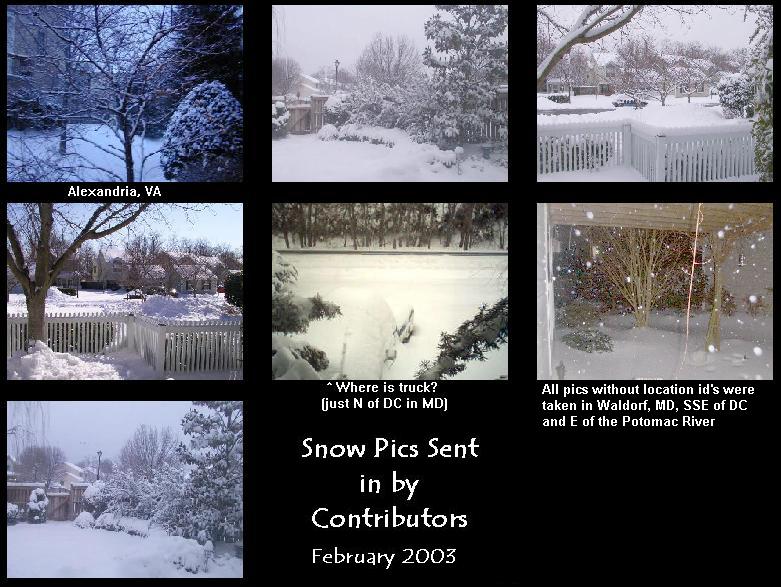
Falls Church - "
February 2003 was colder, wetter and snowier than average. This was the
snowiest February since 1996. The President's Day storm brought a total of
15.4" from 2/15-2/17. I was snowed in for about 5 days!!!
" - notes from Erica
[ - + ]
Herndon Bob notes: "
My precip was more than 3" above 'normal'.
Average max temp was 8° below the Dulles 'normal';
average min was near 'normal'. Dulles is about 4 miles WSW.
"
[ - + ]
Herndon -
"
The monthly temperature was 4.0° below average,
precipitation was 4.47" above average, snowfall was
29.3" above average. We had measurable snow on the
6th (3.25"), 7th (2.9"), 10th (0.25"), 15th (1.0"),
16th (18.5" - new extreme), 17th (2.5"), 18th (0.5"), 26th (1.8"),
27th (4.0" - new extreme) and 28th (0.8"). Quite a month for snow
lovers. Schools were closed for the better part of two
weeks. Sleet fell on the 15th, 16th, and 17th. Freezing
rain fell on the 15th. Dense fog formed on the 1st, 21st
and 22nd."
" - report from Russ [ - + ]
Louisa -
"February was certainly the 'winter' month here.
Over 22" of snow and sleet for the month;
the resulting melt has the ground water level up
and Lake Anna's level a little above normal." - notes from Joe Bowers.
Lynchburg -
Rainfall for the month was 2.65" above normal while
the mean temp was 2.4° below normal. The average wind speed was
5.6 MPH. - from NWS Blacksburg
[ - + ]
Newport News - Gary reports: "
A real drought buster this month with precipitation
on 18 of the 28 days."
- [ - + ]
Norfolk - NWS AKQ reported the mean temp at ORF was 1.0° below normal.
Rainfall was 1.91" above normal. The average wind speed was 10.1 mph. Sky cover
was 60%. The average relative humidity was 73%. [ - + ]
Norfolk - The Fred Heutte Center, in Historic Ghent, noted a mean barometer reading
of 30.010". The mean relative humidity was 76%. The average wind speed was
5.0 mph from a dominant NE direction.
Portsmouth - While the cold temps of January were followed by more
seasonal temps this February, moisture levels increased over those of a dry January. During
the month, temps averaged just below normal (-1.2°) and precipitation was well-
above normal (166%). Winds averaged 4.9 MPH from a dominant SW direction. A rather
low barometer on the 23rd with 29.212" . Series of lows moved across the Mid-Atlantic
bringing abundant moisture across the region as cold high pressure moved E across
the Great Lakes and New England regions. A few station records were established
during the month: 15th - PRECIPITATION - 0.84" [PREVIOUSLY 0.81" IN 1995];
22nd - TEMPERATURE - 75° [PREVIOUSLY 73° in 1985];
24th - WIND - 47 MPH [PREVIOUSLY 43 MPH in 1984]. The average relative humidity
was 76% and the average sky cover was 46%.
[ - + ]
Richmond - NWS AKQ reported the mean temp at RIC was 2.8° below normal.
Rainfall was 1.23" above normal. The average sky cover was 70% while the average relative humidity was 75%.
The average wind speed was 7.9 mph. [ - + ]
Mechanicsville - Glenn notes: "
Some thunder on the 18th and 22nd- A lot of snow and periods of snow occurred during
the month. Come on spring!
"
Roanoke - Wendell notes: "
A wet and snowy, windy February with snowfall of 11 inches, 4.5" above
the norm for the month. Rainfall was 2.86" above normal and included snow and sleet
melt. Temps were 2.3° below normal. A real winter month for a change.
- [ - + ]
Roanoke - NWS Blacksburg reports that the monthly mean temp was
3.4° below normal. Rainfall was 2.72" above normal. [ - + ]
Woodstock -
"
Last February was the warmest in 17 years of records. This year
was the little ice age---the coldest in 18 years of
records, and the
wettest (by 2"). We had snow cover on 24 days (22 consecutive)
and
with 10" of mostly ice--snow so crusty I can walk on top-- and
more chilly weather forecast it will be the middle of March before I can
even see the leaves of the spring bulbs. Last year the first bloom was
Feb. 16.
" - notes from Lauck [ - + ]
North Carolina:
Asheville - from NWS GSP: The monthly mean temp was 0.6° above
normal and the rainfall was 0.64" above normal. The average wind speed was
7.7 mph. Average relative humidity 69% while the average sky cover was 50%.
[ + + ]
Charlotte - NWS GSP reports the mean temp here was 2.6° below normal
and precip was 0.06" above normal. The average wind speed was 6.5 mph.
The average sky cover and relative humidity were 70% and 69% respectively.
[ - + ]
Elizabeth City - The Elizabeth City Coast Guard Station [ECG]
reported an average wind speed of 11.1 mph. The mean temp was 2.4° below normal
while rainfall was 2.86" above normal. The average relative humidity was 76% while
the average sky cover was 50%. - from NWS AKQ [ - + ]
Fayetteville - NWS RDU reports the average wind speed was 7.3 mph and
the average relative humidity was 68% while the average sky cover was 50%.
Cape Hatteras -
The average temperature was 47.0°. This was 0.6° warmer than the 1895-2003
average, the 50th warmest February on record (1895-2003).
3.75" of precipitation fell in February. This was 0.90" less than the
1895-2003 average, the 37th driest such month on record (1895-2003).
- from NCDC [ + - ]
Greensboro - NWS RDU notes a mean temp here of 1.2° below normal.
Rainfall was 1.81" above normal. The average wind speed was 7.8 mph.
The average relative humidity was 70%. The average sky cover was 70%.
2.14" of rain on the 22nd established an new daily precip record surpassing
the 0.79"set in 1971.
- [ - + ]
Lumberton - The average wind speed was 7.5 mph. The average monthly
temperature 0.1° below normal while rainfall was 0.19" above normal - from NWS ILM
[ - + ]
Raleigh - NWS RAH reported the monthly average temp was 1.9° below
normal while rainfall was 1.17" above normal. The average relative humidity
was 70% while the average sky cover was 60%.
THE RECORD DAILY PRECIPITATION FOR FEBRUARY 22ND WAS 0.76"
SET IN 1987. THAT CHANGED TO 0.83" IN 2003 ON THAT DATE.
- [ - + ]
Raleigh - Bob reports: "
February weather was a very active month with 3 events that produced
frozen precipitation and one event that produced some severe weather
including tornado warnings in the area. Central Carolina Skywarn
(http://www.ccskywarn.net) was activated four times during the month.
The three winter events only produced a little over 1.70" of frozen accumulation,
most which was in the form of sleet. The average daily temperature for
February was below normal while precipitation was above normal.
"
- [ - + ]
Roxboro - In his monthly report, Merriell notes: "
February was colder than normal with more precipitation than normal. Periods
of mixed wintry precipitation and thunderstorm activity kept the month active
and interesting.
"
- [ - + ]
Wilmington - From NWS ILM:
The average temp was 1.5° below
normal while rainfall was a 0.37" above normal.
The average wind speed was 8.2 mph.
RECORD HIGH TEMPERATURE SET ON 22ND with 78°. The
PREVIOUS RECORD was 77° SET IN 1993.
[ - + ]
South Carolina:
Charleston - NWS CHS reports the monthly mean temp was 0.1° above
normal. Rainfall was 0.62" below normal. The average wind speed was 8.4 mph.
- [ - - ]
Columbia - NWS CAE reports that the mean temp here was 0.3° below
normal. Rainfall was a 0.30" below normal. The average wind speed was 7.1 mph.
Average relative humidity was 66% while the average sky cover was
60%. [ - - ]
Florence - The mean temp here was 2.4° below normal
while rainfall totals were 0.42" below normal. The average wind speed was 7.3 mph.
- from NWS ILM [ - - ]
Greenville-Spartanburg - The monthly mean temperature was 0.6°
below normal while rainfall was 0.22" below normal. The average wind speed
was 7.7 mph.
The average relative humidity was 62% and the average sky cover was 30%.
- from NWS GSP [ - - ]
North Myrtle Beach - The mean temp was 1.4° below normal while
rainfall was 0.79" below normal. The average wind speed was 7.2 mph.
- from NWS ILM [ - - ]
Orangeburg - NWS CAE reports the average wind speed was
7.0 mph. The average relative humidity was 72% while the average sky cover
was 40%.
Nearby Cities:
Tri-Cities -
Tri-Cities received 6.32" of precipitation during February, which was 2.92"
above normal. It was the third wettest February on record at Tri-Cities.
Measurable precipitation fell on eighteen days of the month, but only one
day received more than an inch. During a three day period (14-16th),
1.99" of precipitation fell. Another 1.85" fell on the 22nd. The wettest
February at Tri-Cities was back in 1994, when 7.75" was recorded.
The average monthly temperature at Tri-Cities was 37.2°, which was 0.8°
below normal. No daily records were broken. The coldest February at
Tri-Cities was back in 1958, when the average temperature was only 28.1°.
Tri-Cities received 13.17" of precipitation this winter, which was 2.86"
above normal. It was the 9th wettest winter on record at Tri-Cities.
The wettest winter was back in 1956-57, when 19.19" was recorded.
The average seasonal temperature at Tri-Cities was 35.2°, which was 1.3°
below normal. It was the 13th coldest winter on record at Tri-Cities.
The coldest winters were back in 1976-77 and 1977-78, when the average
temperature was only 30.0°.
- from NWS MRX [ - - ]
