...October
Uneventful and Dry...
Weatherwise,
the month was very dry with near normal temperatures. Greenville-Spartanburg
(SC) noted 3.39" of rain, far above all other site totals. Several
of you noted new rankings for dryness when comparing yearly records through
your database. Apparently a rather large pocket of colder than normal
air covered the Raleigh area as a new record for October temps at or below
freezing was established at Bob Woodson's site. One could speculate
that this may have resulted from a higher than usual number of mornings
with calm winds and maximum radiational cooling resulting from the persistent
high pressure over the area. The same effect was noted from southcentral
North Carolina into central South Carolina.
Generally speaking,
high pressure dominated the region with upper air flow from the northwest
and west for the most part. Persistent upper trough over the region
helped cool air slip over the region from southern and southeastern Canada
but there were no cold weather outbreaks. A few days of zonal flow
helped keep the weather rather static as well.
Bob Beall in
Herndon noted only 3 frosty mornings during the month, seemingly a record
itself, although he has no historical data to compare.
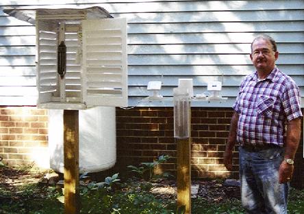
Member Profile: Glenn L.
Martin, Mechanicsville, VA
Longtime member
Glenn writes: "When I was 12 years old I became interested in the
weather. I started recording meteorological data when I was about
17 years old. In the mid-80s I sent data to the University of Virginia
and, at that time, was a member of the American Meteorological Society.
In the early 90s I became a member with the Atlantic Coast Observation
Network. The station that I now use is an Oregon Scientific weather
station. It is capable of measuring high and low temperatures, relative
humidity, barometric pressure, wind direction, wind speed, and wind chill."
Snowfall
Remember, 'tis
time to restart your totals for 2001-2002. We tally seasonal snowfalls
in these reports; so, if you keep yearly totals, please adjust for seasonal
amounts and report those as well. Don't forget to read member
Lowell Koontz' Snowfall
Measurement paper at http://www.pilot.infi.net/~bsmoot/koontz.htm
Again, have
you read David Tolleris' (Wxrisk.com) interesting winter 2001-2002 forecast?
Check this out:
http://www.wxrisk.com/Seasonalforcst/Winter01-02/Winter2001-02.htm
Skywarn
Bob Woodson
sends the local Skywarn Web address: http://www.centralcarolinaskywarn.net |

ACON
- VA/NC/SC
The Atlantic
Coast Observer Network:
Virginia,
North Carolina, South Carolina
http://www.pilot.infi.net/~bsmoot/acon.htm
SUMMARY OF
CLIMATOLOGICAL DATA
OCTOBER
2001
Patrick Maloit's OCTOBER 2001
Hydrological Report -
Narrative Summary:(
will be reprinted online when available)
http://tgsv5.nws.noaa.gov/er/akq/HYM/OctPre2001.htm
( first snowfall
of season at CHW - October 27th, 2001 )
Canaan Heights to Become
Official NWS Cooperative Site
Dave writes
via email: "Proud to announce that our location here in Canaan Heights,
WV has been approved to become an official NWS co-op station. Will
record and report daily max and min temperature, precip, snowfall, snow
depth, and snow cover water equivalent. Probably will not be fully
up with all equipment installed and operating until spring. Station
name will be Davis 3SE."
WREL Wants Your Storm Reports!!
Scott Lancey
writes from Lexington, VA: "I might mention we post current conditions
from our WeatherCenter at http://www.wrel.com/wx.htm.
We also have a email weather update service that ships out watches and
warnings along with a discussions of potential significant weather along
the mid-Atlantic. Our update readers often submit reports and on occasion,
photos (most recently of the MD tornado). Info on the updates is
at http://www.wrel.com/updates.htm.
I'd welcome any ACON reporters to sign up and submit storm information...it's
very helpful.
|

For ACON
VA/NC/SC Recent Weather News, Search CNN
http://www.cnn.com/WEATHER
ACON
VA/NC/SC Member Station Extremes - October 2001
|
State
|
Maximum Temperature
|
Minimum
Temperature
|
Warmest
Average
Temperature
|
Coldest
Average
Temperature
|
Maximum
Precipitation
|
Minimum
Precipitation
|
|
Virginia
|
88°
Newport News
|
20°
Newmarket
|
61.3°
Norfolk
|
51.5°
Blacksburg
|
1.49"
Charlottesville
|
0.30"
Lexington
|
|
North Carolina
|
88°
Lumberton
|
26°
Asheville, Brevard, Charlotte, Concord,
Raleigh (RAL)
|
62.7°
Wilmington
|
53.9°
Asheville
|
1.86"
Raleigh (RDU)
|
0.40"
Greensboro
|
|
South Carolina
|
89°
Columbia
|
27°
Columbia
|
64.8°
Charleston
|
58.0°
Greenville-Spartanburg
|
3.39"
Greenville-Spartanburg
|
0.17"
Columbia
|
Virginia:
Annandale - "October
temperatures were average with a departure of only +0.1°F but very
dry with a -2.31 inch departure. It was the second driest in the
last 21 years with last year being the driest on record. Only 4 days
had measurable rain the least on record except for last year when the record
of only 2 days occurred. High pressure was the controlling feature
on 23 days giving the clearest October on record. (Records since 1980)
With all the clear skies the lowest daily temperature range was 11°
the highest in Oct. since 1987 departure +5.4°. On October 9th
the barometric pressure was 30.69 inches the highest for October since
1986. It was also windy; the average maximum PM wind was 15.68mph
the most since 1981. The maximum gust of 34mph was the highest since 1996.
October 6, 2001 Windy The highest wind gust of 26 mph occurred today
at 0946 from the west. This was the highest wind recorded since
August 10, 2001 when we had a 28 mph gust. October 7, 2001 Low Maximum
and Minimum temperature The maximum temperature today was 54°F, a new
21-year low maximum temperature record for the date; the old record was
55°F in 1988. The minimum temperature today was 40°F, the lowest
minimum temperature record for the date since 1992 when it was 38°F.
It was also the lowest minimum since May 7, 2001 when it was also 40°F.
October 8, 2001 Low Minimum temperature The minimum temperature today was
36°F, and equaled the 21-year low minimum temperature record for the
date; the old record was set in 2000. It was also the lowest minimum
since April 19, 2001 when it was 31°F. October 9, 2001 Record
Low Minimum temperature The minimum temperature today was 33°F, a new
21-year low minimum temperature record for the date; the old record was
35°F in 1987 and 1988. It was also the lowest minimum since April
19, 2001 when it was 31°F. October 16, 2001 Record Maximum Precipitation
for the Date The precipitation total today was ONLY 0.24 inches, but a
new 21-year maximum precipitation record for the date; the old record was
ONLY 0.14 inches set in 1984. October 23, 2001 Record High Maximum temperature
The maximum temperature today was 76°F, a new 21-year high maximum
temperature record for the date; the old record was 73°F in 1986.
October 24, 2001 Record High Minimum
temperature The minimum temperature today was 60°F, and equaled the
21-year high minimum temperature record for the date; the old record was
set in 1985. The maximum temperature today was 78°F, a new 21-year
high maximum temperature record for the date; the old record was 70°F
in 1995. October 25, 2001 Record High Maximum temperature today The
maximum temperature today was 73°F, a new 21-year high maximum temperature
record for the date; the old record was 70°F in 1991. October
26, 2001 Windy Afternoon The highest wind gust of 34 mph occurred from
the WNW today at 1733 hrs. This was the highest wind recorded
since March 23, 2001 when we had a 37 mph gust." [ + - ] - report
form Lowell
Arlington - NWS WBC reports:
"On the 24th the high temperature reached 84 degrees breaking the previous
record of 80 set in 1900. It is hard to get rain in October recently.
The past four years have produced below normal rainfall for the month.
This year Washington had less than an inch of rain spread over four days
in October. Further complicating the situation was that this
dry month was preceded by a very dry September. The combined 2.10 inches
of rain received during those two months was an exceedingly low total.
In fact...during Washington's 131 years of record...there have only
been four other years with that low of a total. The most recent was more
than 30 years ago...and all three in this century were followed by a dry
November: 2001 --> 2.10 inches; 1967 --> 1.97 inches; 1941 --> 1.92 inches;
1930 --> 1.04 inches ... the great drought of 1930-31; 1884 --> 1.87 inches.
The result of this during the fall season is a high wildfire danger.
Please be careful with all outdoor fires and cigarettes. Although
temperatures varied by quite a bit from day to day...the end result for
the monthly departure was exactly normal. The warmest day was a record
breaker on the 24th when the high temperature reached 84 degrees and broke
a 101 year old record by four degrees. Most days were in the 60s
and 70s...although there were five days that never made it out of the 50s.
Most of the region saw their
first freezing temperature during
October...but National Airport...aided by the warming influence of the
Potomac only fell to 33 degrees. That coldest temperature for the
season so far was attained on the 29th. The average wind speed was
8.6 mph. " [ - -]
Ashburn - Gary sends these
notes: "Ah, finally some weather! Temperature was exactly 1.0°
F above normal; rainfall was 2.02 below normal. On 3 days, we had
wind peaks of 30 mph, a record in the short life of my station. On
3 other days, wind peaks were shy of 30 but in themselves would have been
new records for the station, average wind speed was 1.7 mph. Dominant
wind direction was WNW. The high and low barometric pressures for
the month were both station records as well. First freeze of the
fall occurred this month (dipping to a downright chilly 26.7° F), and
two other days were below 32° as well. No thunderstorms and little
fog. Very dry overall, and several days worth of Red Flag Warnings
for high fire danger at the end of the month. The Climate Prediction
Center is forecasting continued dryness at least until mid-November.
[ + -]
Blacksburg - NWS RNK BCB reports
that the mean temp was 0.5° below normal while monthly precip was 2.08"
below normal. [ - - ]
Bridgewater - Clayton writes:
"Rainfall was 2.36 below normal. Total precipitation for the year so far
is 7.19 inches below normal. Since the first of January, 1999, the precipitation
is a little over 16 inches below normal. North River, which
flows by Bridgewater, is the lowest
I have ever seen it. Temperature for the month was just about
normal. The first significant frost occurred on the 6th. Weather
for the month was quite boring!." [ -/+ -]
Centreville - Paul reports:
"There was no weather during October! OK then, just a little.
Our average daily temperature managed to come in just 0.2° above the
55.1° normal. The average daily high was essentially flat too,
being a mere 0.7" greater than the expected 67.7°. Now, the nighttime
low average presents a problem. If it werent for the low for the
month of 22° on October 19th, everything would have been fine.
That cold night nearly threw us into a global freeze sending the monthly
low average to 0.3° below the 42.4° norm. Last month I reported
that several months this year had acquired a large percentage of the rainfall
from episodes when rain events exceeded one inch. October certainly
gets a passing grade in this regard with 78% of the monthly rainfall accumulating
on the 14th with 1.01" of precipitation in 4-1/2 hours; hardly something
youd call a real soaker. Two days later 0.21" of rain fell bringing
to a close any further need for the rain gauge and prompting a rise for
concern for the increasing dryness, which has been building significantly
since the end of August. Next month I hope to report that the rains
have come and that the Governors ban on open burning has been lifted."
[ + - ]
Charlottesville - Rainfall
for the month was 3.08" below normal. Average wind speed was 4.8
mph. - NWS WBC [M -]
Dulles - NWS WBC reports
rainfall was deficient here when compared to the norm by 1.42" while temps
were slightly above normal (+0.7°). [ + -]
Falls Church - Erica notes:
"October 2001 was a month with average temperatures but way below average
in terms of rainfall. A strong cold front on the 16th brought little
rain but some strong winds. My peak gust was 30mph. Another windy day on
the 26th brought a gust of 24mph. " - notes from Erica [ +/- -
]
Harrisonburg - "The average
temperature for October was 1.1° above normal. Rain for the month
at .65" was the lowest monthly total for the year and 3.01" below normal
for October. September and October rain totaled less than two inches total.
Yearly rain is 8.4" below normal. - report from Terry [+- - ]
Herndon - Bob Beall reports:
"A dry month - but October 2000 (0.15 inches) will hold the record
for this month for some years - maybe. Only 3 morning frosts
were noted."
Herndon - Russ notes:
"October rainfall was 1.74 inches below normal. Temperatures
averaged 1.5° above normal. A record high temperature of 82.3°
was recorded at my station on the 24th. Record minimum temperatures of
32.4° on the 8th and 26.7° on the 9th were also recorded. A single
day precipitation record of 1.10 inches of rain occurred on the 14th."
[
+ -]
Louisa - "Dry! How dry is it
? So dry I can't think of a Henny Youngman joke for it ! Lake
Anna is over two and a half feet below normal. Water flow over the dam
into the North Anna River has been decreased to keep lake level from
falling, but even that isn't enough.
32 days to date (11/18) without any precip." [M -]
Lexington - "Yet another bone
dry month. Measurable precipitation was recorded on only one day
for the entire month. This is approximately 3 inches below monthly normal.
October's mean temperature was 1.7° above average." - Scott Lancey
for WREL Radio
Lynchburg - The mean temp was
2.9° below normal while precip was 3.00" below the norm. A record
low was tied on the 29th with 25° and first set in 1976. - NWS Blacksburg
[
- -]
Newport News - Gary notes:
"The dry weather from September has carried over through October with only
2 days with measurable rain." [ M - ]
New Market - Joyce sends these
notes: "We are 3° cooler for the month and 2" below average in precipitation
for the month. Everything is dusty and dirty this month. They are
building road in front of us and we have lived with this dust for 2 months.
Sure will be glad when they get it finished. We had forest fire this
past weekend and we could see it from out house. We met 65 firefighters
from California early Sunday morning, who were eating breakfast and on
their way to fight the fire." [ - - ]
Norfolk - NWS AKQ reports the
mean temperature was 0.1° above normal while rainfall was 2.40" below
normal. Yearly rainfall was running 7.11" below normal. The
average wind speed was 8.4 mph. [ + - ]
Portsmouth - A slightly cooler
than normal October (-0.9°) and extremely dry month - but not as dry
as last year - with a negative departure of 2.61" or 25% of the norm.
Records for the month: 3rd DRIEST
OCTOBER IN DATABASE [SINCE 1976] 7th
- Minimum maximum temperature TIED - 60°
(previously set in 1988); 8th - Minimum maximum temperature TIED -57°
(previously set in 2000); 24th - Maximum temperature - 86
° (previously 81° in 1984); 25th -
Maximum temperature TIED - 80 °
(previously in 1991) For the year, rainfall is only 72% of the norm
(-11.60") [ - - ]
Richmond - Roy reports his
first frost occurred on the 9th.
Richmond - From NWS AKQ:
Richmond's rainfall was 2.88" below normal. Rainfall totals for the
year-to-date were 7.04" below normal. Monthly temps averaged 0.8°
below the norm. The average wind speed was 7.1 MPH. [-
-]
Mechanicsville - Glen
sends these notes: "Temperatures were normal for this month with very little
rainfall." [ +/- - ]
Roanoke - Wendell notes, "Warmer
and drier with temps 0.5° above normal and rainfall 3.30" below normal.
Not as dry although as October 2000 when only 0.01" fell which was the
driest ever." [ + - ]
Roanoke - Temperature
average was 0.4° below normal. Rainfall was below normal (-3.43")
- notes NWS Blacksburg [ - -]
Woodstock - "Lauck reports
temperatures just a little above average, but very dry, 3rd lowest in 16
years." - notes from Lauck
[ + +]
North Carolina:
Asheville - From NWS GSP: The
monthly mean temp was 2.0° below normal while rainfall was 2.99"
below normal. The average wind speed was 4.4 mph. [ -
-]
Brevard - Bob reports:
"October was a cool month, the mean high, 67.3 deg. F, was 2.0 deg. below,
and the mean ow, 41.0, was 2.9 deg below their respective year averages.
However, the most important feature as dry! Only 1.26 inches of rain was
recorded in a month that averages 5.32 inches. With 40.18 inches recorded
for the year, 17.7 below the ten year average, wells in the area are going
dry, and the fire hazard in the national forest which comprises
1/3 rd of the county, is very high."
[ - - ]
Charlotte - NWS GSP reports
the mean temp here was 3.3° below normal while precip was 2.58" below
normal. The average wind speed was 5.2 mph. [ -
- ]
Concord - "The 3+ year drought
continues with only 0.77" of rain (normal is 3.36")measured for the entire
month of October but this was still above the total of 0.00" measured during
October 2000. The month of October 2001 was
also much cooler than normal with
the Avg Mean Temp being 56.9 or 3.1 degrees below normal. High winds, very
little rain, the on-going drought and several days of very low humidity
during the month resulted in several "Red
Flag" days with no outside burning
allowed and several large brushfires which broke out around the Western
half of North Carolina. Also, my official location changed in August
to Lat: 35 deg 37 min North, Long: 80 deg 66 min West or approx 8 miles
SSW of Concord (Downtown)." - report from Tom [ - - ]
Greensboro - Temperatures at
the Piedmont Triad International Airport averaged 1.2° below normal
while precip was 3.09" below the norm. A record low of 33 degrees
was tied on the 9th (1987, 2000). A new record high of 84 degrees
was set on the 24th. The previous record was 82 degrees set in 1940.
The high temperature of 47 degrees on the 27th tied the daily record for
lowest maximum temperature (1957). The monthly precipitation total
of 0.41 inches was the 4th driest October since
records began in 1928. The top three driest were a Trace in
2000, 0.26 inches in 1963, and 0.27 inches in 1953. This
also tied for the tenth driest month ever. - From NWS
RDU [- -]
Lumberton - The average wind
speed was 4.4 MPH. - from NWS ILM
Raleigh (RAL) - Bob notes:
"The average daily temperature for October was 2.2 degrees below normal
while precipitation was 1.15" below normal. This
station recorded 7 days of 32 degrees or lower which is a record.
The previous number of 32 degree readings or lower for October was 3 days.
However the max temperature on October 24th soared to 87 degrees.
Rainfall for the past two months has been 2.42" below normal. Of course,
with the dry conditions there was no severe wx observed at this station."
[
- - ]
Raleigh (RDU) - A record high
of 85 degrees was set on the 23rd. The previous record was 84 degrees
last set in 1978. A record high of 87 degrees was set on the 24th.
The previous record was 82 degrees set in 1984. The mean temperature
was 0.7° below normal while rainfall was 1.00" below normal.
The average relative humidity was 67%. - from NWS RDU [
- -]
Roxboro - Merriell writes:
"October was very dry and much warmer than normal in spite of a few frosty
mornings and subfreezing temperatures on the 29th. The month's temperatures
averaged about 2° above normal. Only about 18% of the month's
normal rainfall was noted. Beautiful fall colors this month." [
+ - ]
Wilmington - "Below normal
temperatures and precipitation for October...The average temperature for
the month 2.6° below normal. Total rainfall was 2.24
inches below normal. This has brought the yearly rainfall deficit to 11.80
inches. Above normal
amounts of sunshine was received with 79 % of possible sunshine.
The normal is 64%. The average wind speed for october was 6.6 mph.
[ - - ]
South Carolina:
Columbia
- NWS CAE reports the average relative humidity was 62% while the average
temperature was 1.8° below normal. Rainfall was 2.87" below normal.
For the year rainfall is running 17.31" below normal. - NWS CAE [-
-]
Charleston
- From NWS CHS: The monthly mean temp was 2.0° below normal while precip
was 2.25" below the norm. The average wind speed was mph. [
- - ]
Florence
- NWS ILM reports the mean temp here was 2.0° below normal
while rainfall was 1.62" below normal. The average wind speed was
6.0 mph. A record high temperature was tied on the 22nd (83°)
and a record high temperature was tied on the 23rd (87°). [-
-]
Greenville-Spartanburg-
The monthly temps averaged 2.5° below normal while total rainfall was
0.60" below normal. The average wind speed was 4.8 mph. - NWS
GSP [ - - ]
North Myrtle
Beach - From NWS ILM: Rainfall was 2.82" below normal.
Temps averaged 1.1° below normal. The average wind speed was
6.2 MPH. Records: Record low tied on 2nd; Record low
temperature on 7th. Old record 48 degrees in 1991; Record low tied on 8th;
Record high temperature on 22nd. Old record 82 degrees in 1990; Record
high tied on 23rd; Record high temperature on 24th. Old record 82 degrees
in 1951; Record high temperature on 25th. Old record 80 degrees in 1991;
Record low temperature on 28th. Old record 39 degrees in 1994. [
- - ]
Orangeburg
- The average relative humidity was 66%. (from NWS CAE)
Nearby Cities:
Tri-cities/Bristol area noted
temps averaging 3.1° below normal with total rainfall below normal
( -1.75"). For the year, rainfall is 3.45" above normal. -
from NWS Morristown, TN [ - - ]
Canaan Heights - From Dave's
email: "Proud to announce that our location here in Canaan Heights, WV
has been approved to become an official NWS co-op station. Will record
and report daily max and min temperature, precip, snowfall, snow depth,
and snow cover water equivalent. Probably will not be fully up with
all equipment installed and operating until spring. Station name
will be Davis 3SE."
(Please
note the column denotations table below.)
TEMPERATURES / WIND / ELEMENTS
VIRGINIA
STN  A      B    C    D      E F     G    H I  J K L  M     N  O P Q R R1 S
------------------------------------------------------------------------------
AHB 71.3  42.7  56.1  83.2  24 26.7  9   0  0  3 0 30 NW 6,16, 0 0 0 0  1 2400
                                                           17
ANN 65.81 46.55 56.18 78    24 33    9   0  0  0 0 34 W    26  0 0 0 0  0 2400
BCB             51.5  80    24 22 28,29            38   16,26             2400
BRI 70.3  40.3  55.3  86    24 21   29   0  0  8 0             0 0 0 0  0 0515/1600
CEN 68.4  42.1  55.3  83     4 22    9   0  0  4 0 32 315°  5  0 0 0 0  0 1200/2400
CHO 69.8  40.9  55.3  83    24 25   29   0  0  8 0 35 290° 16  1 0 0 0  1 2400
DCA 70.6  48.7  59.7  84  3,4, 33   29   0  0  0 0 40 310° 16  0 0 0 0  0 2400
                            24
IAD 70.1  41.5  55.8  84    24 26    9   0  0  5 0 41 290° 26             2400
                                                   27 230° 26
FCH 70.3  48.2  59.3  84  4,24 33   29   0  0  0 0 30      16  0 0 0 0  0 2400
HRG 68.2  39.8  54.2  83.0  24 24.3 29   0  0  6 0 22 SSW  16  0 0 0 0  0 2400
HER 67.1  44.8  55.9  80.8  24 29.8 29   0  0  2 0 21       6  0 0 0 0    2400
HRN 68.2  44.3  56.6  82.3  24 26.7  9   0  0  2 0 31 W    17  0 0 0 0  0 2400
LKU 71.8  38.7  55.2  85    24 21   29   0  0  9 0 28 N    25  0 0 0 0  1 2400
LYH             54.1  83    24 25 28,29            35      26             2400
LXI 69.3  37.1  53.1  81.4   4 22.5 29   0  0 10 0 39 WNW  26  0 0 0 0  6 2400
NEW 65.48 38.97 52.23 85    24 20   29   0  0  8 0 42 W    25  0 0 0 0  0 1700
NPN 73.0  47.4  60.2  88    24 33 9,29   0  0  0 0 33 NNE   6  0 0 0 0  0 2300
NOR 72.3  49.6  61.0  86    24 35   30   0  0  0 0             0 0 0 0  0 2400
ORF 71.0  51.6  61.3  86    24 37   30   0  0  0 0 32 020° 26  0 0 0 0  2 2400
POR 70.5  50.5  60.5  86    24 37 29,30  0  0  0 0 31 W    26  0 0 0 0  1 2400
MEC 70    46    58    82    24 28   29   0  0  3 0             0 0 0 0  0 1800
RIC 72.3  45.8  59.1  86    24 31   29   0  0  1 0 39 260° 25  0 0 0 0  1 2400
RMD 73.0  48.4  60.7  85    24 31   27   0  0  1 0             0          2300
ROA             56.9  85    24 28   29             38      25             2400
ROK 71.6  41.8  56.7  86    24 25   29   0  0  7 0 29 NW   25  0 0 0 0  0 2200
AKQ 76.06 43.58 58.82 86    24 27   29   0  0  8 0                        2400
WOO 68.3  47.0  57.6  84    25 32   29   0  0  1 0             0 0 0 0  0 0800
WSH 67.7  45.7  56.7  82.4  24 32.1 29   0  0  0 0 18 SSE  25, 0 0 0 0  0 2400
                                                           26
NORTH CAROLINA
STN  A      B    C    D      E F    G     H I  J K L  M     N  O P Q R R1 S
------------------------------------------------------------------------------
AVL 67.5  40.2  53.9  81    24 26   29   0  0  8 0 39 330° 27  0 0 0 0  5 2400
BRE 67.3  41.0  54.0  75   2,4 26   18   0  0  5 0 22       1  0 0 0 0  6 1600
                          23,24
CLT 72.2  43.9  58.0  84    24 26   28   0  0  5 0 30 290° 25  2 0 0 0  1 2400
CND 72.1  41.9  56.9  84.1  24 26.1 29   0  0  6 0 30 NW   16  1 0 0 0  7 2400
GSO 70.7  44.0  57.4  84    24 28   29   0  0  3 0 39 280° 25  1 0 0 0  0 2400
LBT 75.6  45.5  60.5  88    24 27   29   0  0  4 0 40 270   6  1 0 0 0  6 2400
RAL 73.4  42.3  57.9  85    24 26   29   0  0  7 0 28      14  1 0 0 0  0 1900
RDU 73.9  44.8  59.4  87    24 28   29   0  0  3 0 32 350° 26  1 0 0 0  1 2400
ROX 72.9  46.6  59.8  86.0  24 27.0 29   0  0  3 0 33 NW   26  1 0 0 0  0 2100
ILM 75.2  50.2  62.7  87  6,24 32   29   0  0  1 0 32 300° 16  0 0 0 0  4 2400
                            25
SOUTH CAROLINA
STN  A      B    C    D      E F    G    H  I  J K L  M     N  O P Q R R1 S
------------------------------------------------------------------------------
CAE 76.4  47.6  61.5  89     2 27   29                                    2400
CHS 77.1  52.5  64.8  88    25 34   29   0  0  0 0 35 210° 14             2400
CRE 75.8  51.0  63.4  88    25 30   29   0  0  3 0 26 100° 10  0 0 0 0  5 2400
FLO 75.9  48.1  62.0  87 23,24 30   29   0  0  3 0 31 240° 14  0 0 0 0  3 2400
GSP 70.7  45.3  58.0  82    24 29   28             31 270° 14  2 0 0 0  1 2400
OGB 76.2  48.3  62.2  87    24 29   29                                    2400
NEARBY LOCATIONS
STN  A      B    C    D      E F    G    H  I  J K L  M     N  O P Q R R1 S
------------------------------------------------------------------------------
TRI 68.9  38.3  53.6  83    24 25   29   0  0  7 0                        2400
CHW 54.6  36.5  45.6  69.6  24 19.3 29   0  2 10 0             0 0 0 1  1 1900
(Please
note the column denotations table below.)
PRECIPITATION / BAROMETRIC PRESSURE
VIRGINIA
STN  T     U       V      V1   W X   Y      Z  1  2 3    4    5      6       7        S
-----------------------------------------------------------------------------------------
AHB  1.18  0.71 14 0.71    14  3 0 37.67  0.0          0.0  0.0  30.673  9 29.558 25 2400
ANN  1.00  0.61 14 0.61    14  4 0 33.68  0.0          0.0  0.0  30.69   9 29.59  25 2400
BCB  1.17  0.92 14                                       T    T                      2400
BRI  0.69  0.66 14 0.66    14  2 0 25.64  0.0          0.0  0.0  30.45     29.68     0515/1600
CEN  1.29  1.01 14 1.01    14  3 1 36.90  0.0          0.0  0.0  30.75  15 29.64  24 2400
CHO  1.49  1.43 14 1.43    14  3 1        0.0          0.0  0.0                      2400
DCA  0.69  0.32 14 0.32    14  4 0 28.91  0.0          0.0  0.0                      2400
IAD  1.42  1.10 14 1.10    14  3 1 33.33  0.0          0.0  0.0                      2400
FCH  0.79  0.32 14 0.32    14  4 0 32.22  0.0          0.0  0.0                      2400
HRG  0.65  0.61 14 0.62 14-15  2 0 23.03  0.0          0.0  0.0  30.63   9 29.68  25 2400
HER  1.32  0.96 14 0.96    14  3 0 38.55  0.0          0.0  0.0  30.72   9 29.48  25 2400
HRN  1.46  1.10 14 1.10    14  3 1 36.10  0.0          0.0  0.0  30.657  9 29.624 25 2400
LKU  0.94  0.76 15 0.76    15  3 0 27.63  0.0          0.0  0.0  30.69     29.63     2400
LYH  0.70  0.68 14 0.68    14                                                        2400
LXI  0.30  0.30 24 0.30    14  1 0 30.42  0.0          0.0  0.0  30.66  26 29.67   9 2400
NEW  0.63  0.33 14             3 0 30.81  0.0          0.0  0.0                      1700
NPN  0.53  0.29  6 0.29     6  2 0 30.02  0.0          0.0  0.0  30.68   9 29.65  25 2300
NOR  0.80  0.55  6 0.55     6  2 0 32.03  0.0          0.0  0.0                      2400
ORF  0.75  0.55  6 0.55     6  2 0 31.45  0.0          0.0  0.0  30.59  29 29.69  25 2400
POR  0.86  0.53  6 0.53     6  2 0 29.73  0.0          0.0  0.0  30.657  9 29.690 25 2400
MEC  0.63  0.39  6 0.39     6  2 0 36.70  0.0          0.0  0.0  30.37   9 29.53  24 1800
RIC  0.65  0.36 14 0.36    14  2 0 29.68  0.0          0.0  0.0  30.70   9 29.69  25 2400
RMD  0.48  0.30 14             2 0 34.50  0.0          0.0  0.0                      2300
ROA  0.42  0.41 14                                       T    T                      2400
ROK  0.72  0.72 14 0.72    14  1 0 30.00  0.0          0.0  0.0  30.65   9 29.71  25 2400
AKQ  0.76  0.44 14             2 0 32.18  0.0          0.0  0.0                      2400
WOO  0.83          0.68 14-15  4 0 29.69  0.0          0.0  0.0  30.84  29 30.05  25 0800
WSH  0.79  0.64 14 0.64    14  3 0 30.94  0.0          0.0  0.0  30.70   9 29.67  25 2400
NORTH CAROLINA
STN  T     U       V      V1   W X   Y     Z   1  2 3  4     5       6       7        S
-----------------------------------------------------------------------------------------
AVL  0.60  0.38 14 0.40 13-14  5 0 30.73  0.0          0.0  0.0  30.62  29 29.73  24 2400
BRE  1.26          0.70    14  6 0 40.18  0.0          0.0  0.0  30.61   9           1600
CLT  0.78  0.32 25 0.32    25  3 0 24.22  0.0          0.0  0.0                      2400
CND  0.77  0.31 25 0.31    25  3 0 31.64  0.0          0.0  0.0  30.65   9 29.79  25 2400
GSO  0.41  0.27 14             3 0                                                   2400
LBT  1.44  0.96  6 0.96     6  5 0 33.70  0.0          0.0  0.0  30.62  29 29.80  24 2400
RAL  1.71          1.21 13-14  3 1 34.50  0.0          0.0  0.0  30.65   9 29.80 24, 1900
                                                                                  25
RDU  1.86  1.40 14             3 1        0.0          0.0  0.0
ROX  0.68  0.58 14 0.54    14  2 0 30.71  0.0          0.0  0.0  30.69   9 29.73  25 2100
ILM  0.45  0.26  6 0.26     6  3 0 38.72  0.0          0.0  0.0  30.59  29 29.82  24 2400
SOUTH CAROLINA
STN  T     U       V      V1   W X   Y     Z   1  2 3  4     5       6       7        S
-----------------------------------------------------------------------------------------
CAE  0.17                          26.11  0.0          0.0  0.0                      2400
CHS  0.65                      3 0 37.75  0.0          0.0  0.0                      2400
CRE  0.28  0.17 14 0.17    14  3 0 35.66  0.0          0.0  0.0  30.59  29 29.82  24 2400
FLO  1.01  0.61  6 0.61   5-6  2 0 30.01  0.0          0.0  0.0  30.61  29 29.77  14 2400
GSP  3.39  1.58 14 1.58    14  4 0 36.17  0.0          0.0  0.0  30.61  29 29.74  24 2400
OGB  0.45                          27.44  0.0          0.0  0.0                      2400
NEARBY LOCATIONS
STN  T     U       V      V1   W X   Y     Z   1  2 3  4     5       6       7        S
-----------------------------------------------------------------------------------------
TRI  0.84  0.29 25 0.29    25  5 0 37.84  0.0          0.0  0.0                      2400
CHW  1.13  0.36 14            11 0        1.7 27  5 1  2.4  2.4                      1900
COLUMN
DENOTATIONS:
| A maximum mean temperature |
T total precipitation (inches) |
| B minimum mean temperature |
U maximum calendar day precipitation
(inches) |
| C monthly mean temperature |
U1 date of maximum calendar day precipitation |
| D maximum temperature |
V date(s) of maximum daily
precipitation |
| E date(s) of maximum
temperature |
V1 maximum 24-hour precip.
& date(s) |
| F minimum temperature |
W number of days with precip.
>= .01" |
| G date(s) of minimum
temperature |
X number of days with precip.
>= 1.0" |
| H days with maximum
temperature >=90 |
Y year-to-date precipitation
(inches) |
| I days with maximum
temperature <=32 |
Z maximum calendar day snowfall
(inches) |
| J days with minimum
temperature <=32 |
1 date of maximum calendar
day snowfall (inches) |
| K days with minimum
temperature <= 0 |
2 number of days with snowfall |
| L peak wind gust (miles
per hour) |
3 number of days with snowfall
>= 1.0" |
| M direction of peak
wind gust |
4 total snowfall for
month (inches) |
| N date(s) of peak
wind gust |
5 total snowfall for 2000-2001
season (inches) |
| O number of days with
thunder |
6 maximum barometric pressure
(inches) |
| P number of days with
hail |
6A date of maximum barometric pressure |
| Q number of days with
glaze |
7 minimum barometric pressure
(inches) |
| R number of days with
ice pellets |
7A date of minimum barometric pressure |
| R1 number of days with dense
fog [1/4 mile and less visibility] |
(i) incomplete data |
| S local observation
time for temps/precipitation |
(M) Missing, if listed in
data table |
| ~ "about" |
E estimated |
| + additional
indeterminate number of days |
NR not recorded |
STATION
/ LOCATION (MILES & DIRECTION FROM MAIN POST OFFICE) /OBSERVER / YEAR
RECORDS BEGAN / EMAIL ADDRESS:
| AHB Ashburn,
VA - Gary Oldhaam 7/01 281' AMSL Gary.Oldham@DynCorp.com |
ROK Roanoke,
VA 6SW Wendell Prillaman 4/76 wandlprillaman@home.com |
| ANN Annandale,
VA 1 3/4 ENE - Lowell Koontz 12/90 wwkoontz@bellatlantic.net |
|
| DCA Arlington,
VA NWS Webmaster (Sterling): james.decarufel@noaa.gov |
|
| BCB Blacksburg,
VA NWS Webmaster: William.Perry@noaa.gov |
AKQ Wakefield,
VA NWS Webmaster: Neil.Stuart@noaa.gov |
| BRI
Bridgewater, VA Clayton Towers Ctowers@rica.net |
WSH Washington,
VA David Yowell runamok@runamok.com |
| CEN Centreville,
VA Paul Bassett 1985 pbassett@sitestar.net |
WEE Weems, VA
3WNW Francis J. Socey |
CHO Charlottesville,
VA Airport ASOS (Rappahannock County)
Webmaster (Sterling): james.decarufel@noaa.gov |
WOO Woodstock, VA
5NW Lauck Walton - 12/1/85 jwalton@shentel.net |
| IAD
Dulles International Airport Webmaster (Sterling): james.decarufel@noaa.gov |
AVL Asheville,
NC NWS NWS GSP: bryan.mcavoy@noaa.gov |
| FCH Falls
Church, VA Erica Page - 3/7/94 Windie1970@aol.com |
BRE Brevard,
NC 1SE Bob Keehn 1/1/90 Bob_Keehn@citcom.net |
| FRB Fredericksburg,
VA 7SW Ken McKneely mckneelys@email.msn.com |
CLT Charlotte,
NC NWS NWS GSP: bryan.mcavoy@noaa.gov |
| HAM Hampton,
VA 5NE Dave Kessel 1989 dckessel@home.com |
CND Concord, NC Lat:
35 deg 37 min North, Long: 80 deg 66 min West or approx 8 miles SSW of
Concord (Downtown) stormwatch@vnet.net |
| HRG Harrisonburg,
VA Terry Slagle 5/2000 Altitude: 1306' tslagle@adelphia.net |
GSO Greensboro,
NC NWS Webmaster (Raleigh/RAH): Richard.Jones@noaa.gov |
| HER Herndon,
VA R.M. Beall P- 10/76 T- 1/91 beall47@earthlink.net |
RAL Raleigh,
NC 7NNW Bob Woodson - 6/1/93
kf4mmm@qsl.net |
| HRN Herndon,
VA 4SW Russ Topping - 1985 weatherman@cox.rr.com |
RDU Raleigh-Durham,
NC NWS Webmaster: Richard.Jones@noaa.gov |
| LXI
Lexington, VA Scott M. Lancey, WREL Radio - 06/1996 weather@wrel.com |
|
| LKU
Louisa, VA 1N Joseph Bowers 1944 - NWS
ID 44-5050-02 jmbiii@earthlink.net |
LBT Lumberton, NC FAA Lumberton 34o
37'N 79o 04'W nwsilm@wilmington.net |
| LOU
Louisa, VA 6S John Bullock (about 1970) |
ROX Roxboro,
NC 2SE Merriell A. Jay 1/93 |
| LYH
Lynchburg, VA NWS Webmaster (Blacksburg): William.Perry@noaa.gov |
ILM
Wilmington, NC NWS nwsilm@wilmington.net |
| NEW Newmarket,
VA 2W Joyce Winfree joywood@shentel.net |
CHS Charleston,
SC NWS, Webmaster: Theodore.Rodgers@noaa.gov |
| NPN
Newport News, VA 7N Gary Leonard - 6/91 GaryMLeonard@aol.com |
CAE Columbia,
SC NWS caewx@noaa.gov |
| NOR
Norfolk, VA 3NE Jim Fentress 6/1/77 |
OGB Orangeburg, SC NWS
caewx@noaa.gov |
| ORF
Norfolk, VA 5NE NWS 1871 Webmaster (Wakefield): Hugh.Cobb@noaa.gov |
GSP Greenville-Spartanburg,
SC NWS bryan.mcavoy@noaa.gov |
| POR
Portsmouth, VA 3S Bill Trotter - 7/1/76 pwrs@infi.net |
|
| MEC
Mechanicsville, VA Glen Martin 11/19/91 |
FLO Florence,
SC nwsilm@wilmington.net |
| RMD Richmond,
VA Roy Britt 8/22/83 roybritt@earthlink.net |
CRE North
Myrtle Beach, SC nwsilm@wilmington.net |
| RIC
Richmond, VA NWS Webmaster (Wakefield): Hugh.Cobb@noaa.gov |
TRI
Tri-cities/Bristol, TN NWS Webmaster (Morristown):W-Mrx.Webmaster@noaa.gov |
| ROA Roanoke,
VA Webmaster (Blacksburg): William.Perry@noaa.gov |
CHW Canaan Heights,
WV Dave Lesher wvweather@mountain.net |