Most of that weather remained to the west of this station in southeastern Portsmouth, VA; however, we did receive 0.29" of rain and endured very gusty winds for a good 15 hours as Fran moved to south-central VA. PWRS remained in the northeast and eastern sections of the storm. A wind gust of 60 mph at 4:19 AM EDT was recorded here.
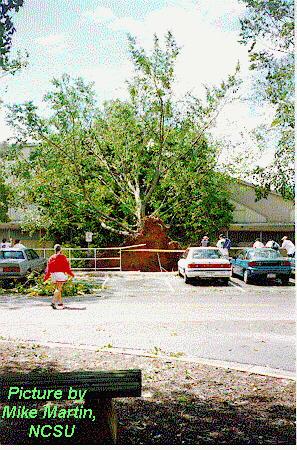
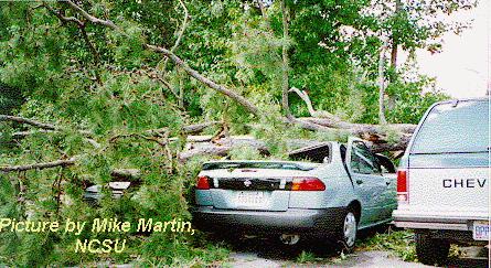
Lots of tree limbs down across the locale; at this station, the greatest side effect was the great amount of small twig and leaf debris left after the storm.
Rainfall: Thursday 0.04"... Friday 0.25"... Storm total 0.29"
Thunderstorm: An embedded thunderstorm was noted Friday morning at 4 AM EDT.
Barometric pressure: Minimum 29.671"
Maximum wind gust: SSE 60 mph at 4:19 AM EDT
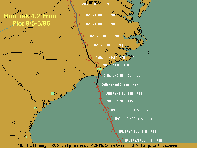
The storm's center moved northwest across the VA/NC border near Danville.
---------------------------------------------------------------------------
                                                 WIND
  TIME   TEMP  HIGH   LOW   BAR   HUM  DEW   STDY  GUST DIR  RAIN
                 (DURING            %  PT.  (miles per hour)(INCHES)
                INTERVAL)
---------------------------------------------------------------------------
09-05-96

 4:00pm  79.3  80.2  78.5  29.951  91  75.8     6    22   E  0.00
 5:00pm  78.1  78.5  77.5  29.950  95  75.9     6    21   E  0.00
 6:00pm  77.2  77.5  77.0  29.920  96  75.8     6    23   E  0.00
 7:00pm  77.1  77.3  72.1  29.921  98  76.2     7    22   E  TRACE RW-
 8:00pm  76.4  77.2  75.9  29.914 100  76.4     7    26   E  0.04
 9:00pm  76.8  77.3  76.2  29.912 100  76.8    10    26   E  0.00
10:00pm  77.3  77.5  77.1  29.874  99  77.2    11    37   E  0.00
11:00pm  77.5  77.6  77.5  29.854  99  77.2    10    31   E  0.00
12:00am  77.6  77.8  77.4  29.818  99  77.3    12    32   E  0.00

09-06-96

 1:00am  77.9  78.0  77.7  29.788  98  77.4    15    46 ESE  0.00
 2:00am  78.0  78.4  77.9  29.740  97  77.2    17    46 ESE  0.00
 3:00am  78.6  78.8  78.4  29.700  97  77.7    20    54 ESE  0.00
 4:00am  78.3  78.8  78.0  29.674  97  77.4    23    58 ESE  0.00
                           ******                    ******
 5:00am  78.0  78.8  76.5  29.671 100  77.5    25    60 ESE  0.25 TRW RW
                           ******                    ******
 6:00am  76.0  76.6  75.4  29.687 100  76.0    23    53 ESE  0.00
 7:00am  75.9  76.6  75.4  29.681 100  75.9    20    40 ESE  0.00
 8:00am  77.0  77.3  76.6  29.689  93  74.8    20    43  SE  0.00
 9:00am  77.7  78.2  77.3  29.702  85  74.2    22    43  SE  0.00
10:00am  78.9  79.9  78.2  29.711  82  73.5    22    51  SE  0.00
11:00am  79.3  79.9  79.0  29.732  84  73.7    19    38  SE  0.00
12:00pm  79.9  80.4  78.9  29.736  82  74.3    20    38 SSE  0.00
 1:00pm  82.0  84.8  79.8  29.733  74  74.5    20    38 SSE  0.00
 2:00pm  86.1  87.1  84.8  29.731  66  75.2    20    40 SSE  0.00
 3:00pm  87.4  87.6  87.0  29.723  67  74.9    19    36 SSE  0.00
 4:00pm  88.0  88.9  87.2  29.746  64  75.0    18    35 SSE  0.00
 5:00pm  87.8  88.2  87.5  29.752  62  73.6    19    33 SSE  0.00
 6:00pm  86.5  87.5  85.5  29.763  67  73.1    17    33 SSE  0.00
 7:00pm  83.8  85.5  82.0  29.771  73  73.0    17    36 SSE  0.00
 8:00pm  80.9  82.0  79.9  29.792  79  72.6    15    27 SSE  0.00
 9:00pm  79.3  79.9  78.8  29.812  82  72.8    15    26 SSE  0.00
10:00pm  78.3  78.8  78.0  29.829  85  72.9    13    22 SSE  0.00
11:00pm  77.9  78.1  77.4  29.842  88  73.6    13    22 SSE  0.00
12:00am  76.8  77.4  76.1  29.859  93  73.8    12    21 SSE  0.00
---------------------------------------------------------------------------
                                                       TOTAL 0.29"
---------------------------------------------------------------------------

                        AROUND THE TWO-STATE REGION:

---------------------------------------------------------------------------
                                  Virginia
---------------------------------------------------------------------------
STATION                 RAINFALL  SUSTAINED GUST     FLOODING  PEAK SEAS
                        (inches) WIND (Mph/Knots)
---------------------------------------------------------------------------
Norfolk International   0.38                         None
Portsmouth - PWRS       0.29               60 mph
Suffolk (Lake Kilby)    1.78
Williamsburg            1.87
Wakefield NWS           3.76
Hampton                                    71 mph
Naval Eastern Oceanographic Center         63 mph
Cape Henry - Virginia Beach                63 mph
Newport News                               59 mph
Hampton - Langley Air Force Base           52 mph
Oceana Naval Air Station - Virginia Beach  48 mph
False Cape buoy - 50 miles east of Virginia Beach              15 feet

Lynchburg               6.94
Charlottesville         5.68+
Chesterfield County     4.77
Danville                2.69
Richmond                1.81               53 mph    Fall Creek; Dan River
                                                     basin; Sugar Hollow;
                                                     Sandy Creek

Tom's Branch           14.30     35-45 mph
Rockingham County                                    flash flooding
Page County                                          flash flooding
Elkton                                               entire city cut-off

---------------------------------------------------------------------------
                               North Carolina
---------------------------------------------------------------------------
STATION                 RAINFALL  SUSTAINED GUST     FLOODING  PEAK SEAS
                        (inches) WIND (Mph/Knots)
---------------------------------------------------------------------------
Rainfall (area wide)    8 to 12
Frying Pan Shoals                         124 mph
Wilmington                                 86 mph
Barrier Islands (unofficial reports of)   140 mph
Beaches of SE NC                 115 mph
Inland SE NC                     60-90 mph
Carolina Beach                                       Entire town under 8 feet
                                                     of water
Storm surge                                                    up to 12 feet
Cape Hatteras           0.42
Northeast NC (northern end)      25-40 mph/74 mph
Northeast NC (southern end)      40-60 mph
Pasquotank River                                     over its banks
Elizabeth City                                       flooding in sections
North Carolina Route 12                              overwashed
Fran Data Graphs
Thursday [5th] Barometer & Wind Gust![Thursday [5th] Barometer & Wind Gust](fran1a.gif)
Friday [6th] Barometer & Wind Gust
![Friday [6th] Barometer & Wind Gust](fran1b.gif)

