
| Portsmouth Weather Records
Service
Local Climatological Data
|
Station: PORTSMOUTH,
VIRGINIA
Month: MARCH Year: 2000 Latitude: 36° 50'N Longitude: 76° 18'W (OFFICIAL CITY) Station Elevation: 20 FT Standard Time: EASTERN STANDARD |
| Temperature | Degree Days | Precipitation | Wind Weather | Weather | Peak Wind | ||||||||||
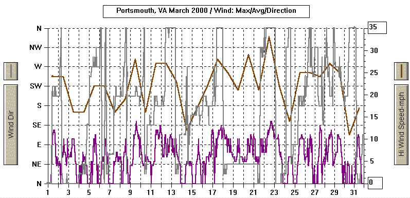
| Date | Max | Min | Mn | Dep | HDD | CDD | Total | Snow | Depth | Avg | Dir | Types | Types | Speed | Dir |
|
|
|
|
|
|
|
|
|
|
|
|
|
|
|
|
|
|
|
|
|
|
|
|
|
|
|
|
|
|
|
|
|
|
|
|
|
|
|
|
|
|
|
|
|
|
|
|
|
|
|
|
|
|
|
|
|
|
|
|
|
|
|
|
|
|
|
|
|
|
|
|
|
|
|
|
|
|
|
|
|
|
|
|
|
|
|
|
|
|
|
|
|
|
|
|
|
|
|
|
|
|
|
|
|
|
|
|
|
|
|
|
|
|
|
|
|
|
|
|
|
|
|
|
|
|
|
|
|
|
|
|
|
|
|
|
|
|
|
|
|
|
|
|
|
|
|
|
|
|
|
|
|
|
|
|
|
|
|
|
|
|
|
|
|
|
|
|
|
|
|
|
|
|
|
|
|
|
|
|
|
|
DST LTG |
-HZ SHRA |
|
|
|
|
|
|
|
|
|
|
|
|
|
|
|
|
|
|
|
|
|
|
|
|
|
|
|
|
|
|
|
|
|
|
|
|
|
|
|
|
|
|
|
|
|
|
|
|
|
|
|
|
|
|
|
|
|
|
|
|
|
|
|
|
|
|
|
|
|
|
|
|
|
|
|
|
|
|
|
|
|
|
|
|
|
|
|
|
|
|
|
|
|
|
|
|
|
|
|
|
|
|
FROPA |
|
|
|
|
|
|
|
|
|
|
|
|
|
|
|
|
COLD |
|
|
|
|
|
|
|
|
|
|
|
|
|
|
|
|
|
|
|
|
|
|
|
|
|
|
|
|
|
|
|
|
COOL |
|
|
|
|
|
|
|
|
|
|
|
|
|
|
|
|
COOL |
DAMP |
|
|
|
|
|
|
|
|
|
|
|
|
|
|
|
|
BR RA DZ |
|
|
|
|
|
|
|
|
|
|
|
|
|
|
|
|
|
|
|
|
|
|
|
|
|
|
|
|
|
|
|
|
|
|
|
|
|
|
|
|
|
|
|
|
|
|
|
|
|
|
|
|
|
|
|
|
|
|
|
|
|
|
|
|
|
|
|
|
|
|
|
|
|
|
|
|
|
|
|
|
|
|
|
|
|
|
|
|
|
|
|
|
|
|
|
|
|
|
|
|
FROPA |
|
|
|
|
|
|
|
|
|
|
|
|
|
|
|
|
|
|
|
|
|
|
|
|
|
|
|
|
|
|
|
|
|
SHRA |
+FG |
|
|
|
|
|
|
|
|
|
|
|
|
|
|
|
|
|
|
|
| Temperature Data
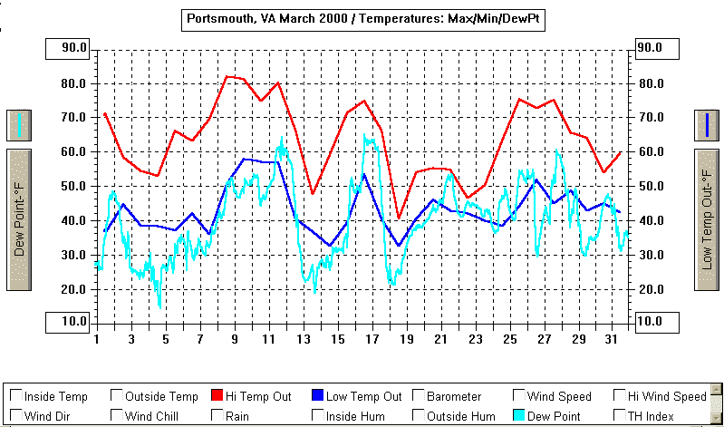
AVERAGE HIGH : 63.8º DEPARTURE: + 3.8º AVERAGE LOW : 43.4º DEPARTURE: + 3.5º MEAN: 53.6º DEPARTURE: + 3.7º HIGHEST: 82º on 8th
Number of Days:
Heating Degree Days
Cooling Degree Days
NUMBER OF: Days Cloudy:
4
|
Precipitation Data
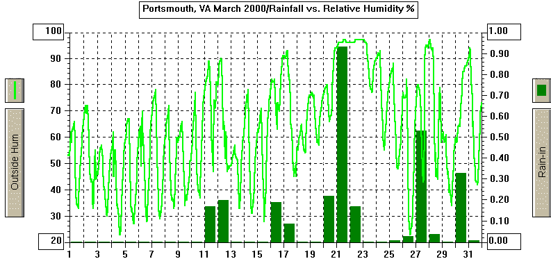
TOTAL FOR THE MONTH: 2.92" DEPARTURE FROM NORMAL: -1.32" or 69% GREATEST DAILY: 0.93" on the 21st GREATEST IN 24- HR PERIOD: 1.17" on the 20th-21st AVERAGE DAILY: 0.09" NORMAL DAILY: 0.14" # DAYS WITH MEASURABLE PRECIPITATION: 13 YEAR-TO-DATE: 9.01" DEPARTURE: -2.76" or 77% of the normal MAXIMUM FOR MARCH: 10.96" in 1994 --> (since
Snowfall, Ice Pellets
MARCH MAX = 14.0" in 1980 Number of Days:
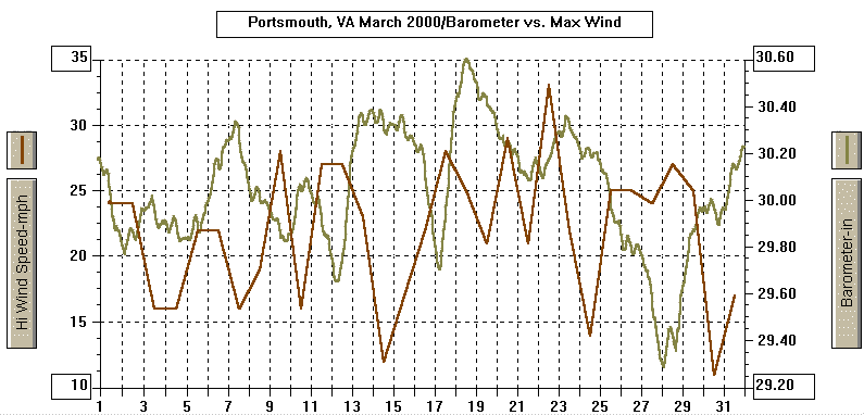
Pressure Data
|
YEAR-TO-DATE 2000 [through 3/31/00; next update 4/30/00]
| Temperature Data
AVERAGE HIGH : 55.3º DEPARTURE: +1.9º AVERAGE LOW : 37.4º DEPARTURE: +2.5º MEAN: 46.3º DEPARTURE: +2.2º HIGHEST: 82º on 8th of March
Number of Days:
Heating Degree Days
Cooling Degree Days
NUMBER OF: Days Cloudy:
14
|
Precipitation Data
TOTAL: 9.01" DEPARTURE FROM NORMAL: -2.76" or 77% GREATEST DAILY: 1.19" on the January 30th GREATEST IN 24- HR PERIOD: 1.29" on January 24th-25th 5PM-5PM AVERAGE DAILY: 0.10" NORMAL DAILY: 0.13" # DAYS WITH MEASURABLE PRECIPITATION: 30 or 77% MAXIMUM: 4.80" in January
Snowfall, Ice Pellets
Number of Days: WITH 0.01" OR MORE PRECIP: 30
Pressure Data
|
| PWRS DENOTATIONS: SU/CL
= Clear sky; PC = Partly cloudy sky; C = cloudy sky; NA, not available;
NR, not recorded; TEMP, temperature; MAX, maximum; MIN, minimum; T, trace
of precipitation; INOP, inoperative equipment; MPH, miles per hour; DN,
departure from normal;
DEP, departure; YR, year; NORM, normal; DST LTG, distant lightning; FROP or FROPA, frontal passage; AM morning; AFT afternoon hours; EVE evening hours; PM evening hours; E estimated; VBL, variable wind directions; TS, tropical storm; |
MARCH 2000 MONTHLY STATION RECORDS:
|
| METAR DENOTATIONS:
BC Patches
METAR Qualifiers: (now placed in FRONT of code) - Light
|