 Tropical Storm
Danny Visits Portsmouth!
Tropical Storm
Danny Visits Portsmouth!
Tropical Storm
Danny Visits Portsmouth!
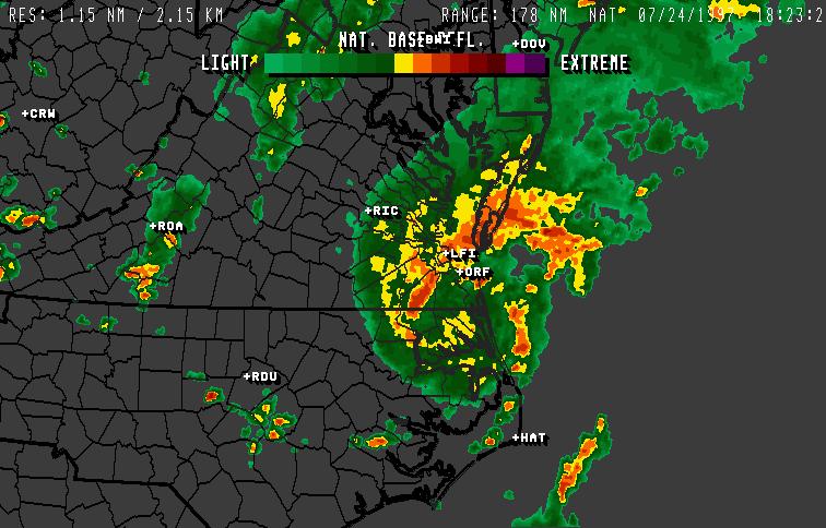
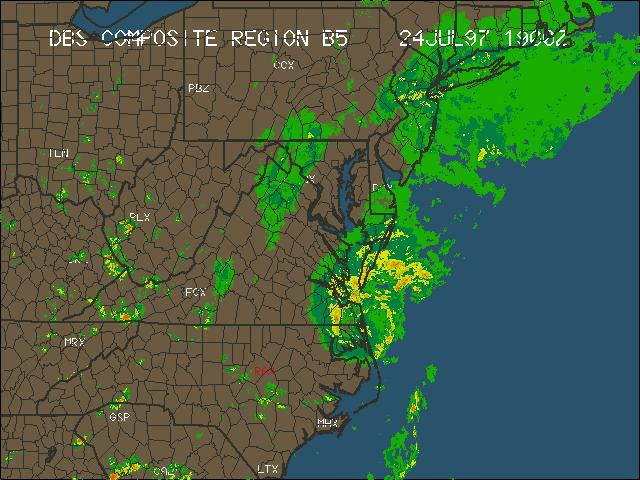
The remnants of Danny [click here for plot] continued moving towards SE VA and by 3:17 PM EDT, the full brunt of the storm was being observed at this station when winds gusted to 56 MPH out of the north. Click here for a radar pick near the height of the storm and as the storm was exiting the coast of SE VA.
The center of the rejuvenating Tropical Storm Danny moved some 40-60 miles south of this station and crossed extreme SE VA near Pungo on to Back Bay. As the storm reached the coast, sustained winds increased to 60 mph.
The lowest observed barometric pressure here was 29.73" while our recorder noted 29.75".
The day began with cloudy skies and ceilings dropping throughout the morning. Showers began about mid-morning. Severe weather messages were posted all day including a tornado watch and tornado warnings, high wind warnings, and flooding statements.
A tornado was spotted locally near the intersection of Poindexter Street and I464 some 2 miles east-northest of this station. There, a car wash was wiped-out by high winds, about 6 businesses suffered damage, and one large truck big-rig wheeler was overturned. As well, a lumber company had its roof torn off. At the time of the tornado sighting, winds briefly gusted to 22 mph. However, strongest winds associated with the eye of the storm and related to bands circulated by the storm were recorded at 3:17 PM, from the North 56 MPH.
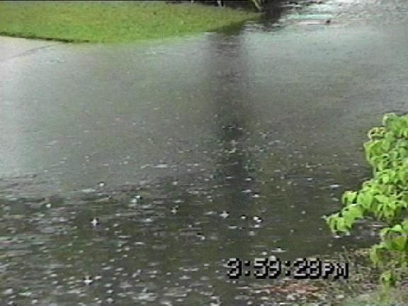
Torrential rains inundated the area with localized flooding right outside our front door. For the day, 1.94" of rain fell with more wrapping around the storm's backside. Rain tappered off in the evening hours.
Winds peaked in the area at the Norfolk Naval Weather Station at 67 mph. Rainfall measured at the Norfolk International Airport was 2.18".

-----------------------------------------------------------------------------------------------------------------------------------
                TH      Temp    Wind    Hi      Low     Hum     Dew     Wind                                    Temp    Hum     Arc
 Date     Time  Index   Out     Chill   Temp    Temp    Out     Pt.     Speed   Hi      Dir        Rain Barom   In      In      Per
-----------------------------------------------------------------------------------------------------------------------------------
 7/24/97  1:00a 80.0    75.5    75.5    75.6    75.4    93      73.3    0.0     0.0     ---        0.00 30.042  78.5    46      60
 7/24/97  2:00a 78.3    75.4    75.4    75.4    75.3    93      73.2    0.0     0.0     ---        0.00 30.027  78.4    46      60
 7/24/97  3:00a 78.3    75.4    75.4    75.5    75.3    93      73.2    0.0     4.0     ---        0.00 30.021  78.5    46      60
 7/24/97  4:00a 78.3    75.3    75.3    75.4    75.2    93      73.1    0.0     4.0     ---        0.00 30.006  78.4    46      60
 7/24/97  5:00a 78.3    75.2    75.2    75.3    75.2    93      73.0    0.0     4.0     S          0.00 30.001  78.2    46      60
 7/24/97  6:00a 78.4    75.3    --      75.4    75.2    94      73.5    0.0     4.0     S          0.00 30.000  78.2    46      60
 7/24/97  7:00a 80.0    75.6    75.6    76.1    75.4    94      73.8    0.0     0.0     ---        0.00 29.984  78.7    46      60
 7/24/97  8:00a 81.5    76.6    76.6    77.2    76.1    95      75.1    0.0     6.0     SSE        0.00 29.997  79.0    46      60
 7/24/97  9:00a 83.4    77.8    77.8    78.3    77.2    94      75.9    4.0     10.0    SSE        0.01 29.991  79.0    46      60
 7/24/97 10:00a 85.8    78.6    78.6    79.1    78.3    94      76.7    4.0     11.0    SSE        0.00 29.968  78.5    46      60
 7/24/97 11:00a 85.8    79.4    79.4    79.6    79.0    94      77.5    4.0     11.0    SE         0.01 29.947  78.4    46      60
 7/24/97 12:00p 87.9    79.6    79.6    79.8    79.4    93      77.4    0.0     6.0     E          0.15 29.905  78.5    46      60
 7/24/97  1:00p 85.6    79.3    --      79.8    78.9    93      77.1    4.0     12.0    E          0.20 29.839  78.9    52      60
 7/24/97  2:00p 83.2    78.3    78.3    79.6    77.4    92      75.8    5.0     22.0    E          0.06 29.780  78.8    48      60
 7/24/97  3:00p 80.0    75.5    75.5    77.4    73.0    95      74.0    6.0     50.0    N          0.69 29.759  79.1    49      60
 7/24/97  4:00p 75.4    71.8    69.3    73.0    71.3    97      70.9    12.0    56.0    N          0.66 29.840  78.5    50      60
 7/24/97  5:00p 75.4    71.7    --      71.8    71.4    97      70.8    7.0     29.0    NNW        0.03 29.899  78.3    50      60
 7/24/97  6:00p 75.6    72.2    72.2    72.5    71.8    98      71.6    4.0     14.0    NNW        0.01 29.915  78.5    49      60
 7/24/97  7:00p 76.6    72.9    72.9    73.0    72.4    98      72.3    0.0     5.0     WNW        0.04 29.931  78.5    49      60
 7/24/97  8:00p 76.6    72.5    72.5    73.0    71.7    98      71.9    4.0     13.0    WNW        0.06 29.943  77.4    52      60
 7/24/97  9:00p 75.6    71.5    71.5    71.7    71.2    98      70.9    4.0     8.0     WNW        0.00 29.972  74.2    52      60
 7/24/97 10:00p 74.6    70.8    --      71.2    70.3    98      70.2    5.0     14.0    NNW        0.02 29.996  73.5    53      60
 7/24/97 11:00p 73.4    69.5    69.5    70.3    68.7    97      68.6    5.0     16.0    NNW        0.00 30.009  74.3    52      60
 7/24/97 11:59p 70.0    68.3    68.3    68.7    68.1    97      67.4    4.0     15.0    NNW        0.00 29.998  73.5    54      60
Chesapeake, Norfolk businesses damaged by tornadoes
BY JUNE ARNEY, The Virginian-Pilot
Copyright 1997, Landmark Communications Inc.
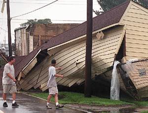
A tornado that touched down in the South Norfolk section of Chesapeake about 1:30 p.m. reduced a car wash to rubble and sent its roof flying, destroyed a lumberyard's storage building, and damaged roofs on several nearby businesses.
A storage building of Burton Lumber in the South Norfolk section of Chesapeake was flattened by one tornado. Photo by Vicki Cronis.At about the same time, a twister hit Norfolk, blowing out car windows at Marine Hydraulics International Inc. before crossing the Eastern Branch of the Elizabeth River and hitting Lyon Shipyard Inc.
No injuries were reported.
Sam Dovak, an employee at Burton Lumber Corp. on Wilson Road in Chesapeake, said she and co-workers saw the tornado coming at them, swirling pieces of metal from the lumberyard as it moved.
``Everyone was panicking and screaming,'' Dovak said. Several people started to walk outside into the storm, she said. Dovak had tears in her eyes as she described rounding up fellow employees and leading them into a closet until the twister passed.
``It was the first time in my life I ever saw a tornado,'' she said. ``I hope it was the last. It was horrible, just horrible.''
Nearby, emergency equipment shoveled bricks that once made up a car wash at Liberty and Commerce streets.
The twister visited several nearby businesses in the area of Liberty Street and Wilson Road before moving on. It damaged roofs at Aard Screen Printing Factory and Townsend Brothers fuel company, both on Seaboard Ave., and at D.D. Jones Transfer & Warehouse Co. Inc.
Into the afternoon, firefighters, inspectors and power company employees fought strong winds and heavy rain to clean up debris and restore order. Firefighters reported seeing two more funnel clouds after they arrived to work the South Norfolk calls.
Robert Walker, chairman of Marine Hydraulics, was crossing the Campostella Bridge when he saw a tornado cross the parking lot of his Norfolk shipyard. The twister knocked over three air conditioning units on the shipyard's offices.
The tornado then crossed the river and flipped over several office trailers at Lyon Shipyard and tore some siding off a warehouse at Moran Towing of Virginia Inc.
Staff writer Christopher Dinsmore and photographer Vicki Cronis contributed to this report.
July 26-27, 1997
Timeline of the storm Thursday
The National Weather Service offices in Wakefield and Newport, N.C., issued the following storm reports as Danny passed Thursday. Many reports are unconfirmed:
12 p.m., Northampton County, N.C. -- Trees and power lines down; power outages, mostly southern and eastern sections of county; occurred between 11:30 a.m. to 2 p.m.
12 p.m., Bertie County, N.C. -- Trees and power lines down; power outages scattered across county; occurred between 11:30 a.m. to 2 p.m.
12:30 p.m., Hertford County, N.C. -- Wind damage from 12:30 p.m. to 1:30 p.m.; trees and power lines down.
1 p.m., Hertford County, N.C. -- Trees and power lines down; scattered power outages, mostly southern part of county; occurred between 12:30 p.m. and 2:30 p.m.
1:15 p.m., Gates County, N.C. -- Wind damage; tress and power lines down; roads blocked along N.C. Routes 1128 and 1129 in the western part of the county.
1:20 p.m., Norfolk -- Spotter reported rotating wall cloud that started in Downtown Norfolk and was moving toward Oceans View.
1:25 p.m., Norfolk -- Coast Guard reported waterspouts and tornadoes heading toward Norfolk.
1:28 p.m., Chesapeake -- Tornado destroyed a car wash at Commerce and Liberty in South Norfolk.
1:28 p.m., Chesapeake -- Tornado; residence damaged on Courtland Street, seven businesses lost or had collapsed roofs; damage estimated at $100,000.
1:30 p.m., Gates County, N.C. -- Scattered Trees and power lines down and some power outages; occurred between 1 p.m. and 3 p.m.
1:30 p.m., Chowan County, N.C. -- Trees and power lines down in scattered areas across county; some power outages; occurred between 1 p.m. and 2:30 p.m.
1:30 p.m., Norfolk -- Spotter reported two tornado touchdowns near Norfolk & Western coal piers.
1:42 p.m., Grandy N.C. -- Currituck County Emergency Management reported water spouts near the North River in southern Currituck County.
1:49 p.m., Virginia Beach -- Funnel cloud on the Chesapeake Bay between Cape Henry and the Lesner Bridge.
1:55 p.m., Virginia Beach -- State Police report a tornado on the ground at Knotts Island.
2 p.m., Hampton -- Police report a street light down at Pembroke and Mallory, possibly the result of a tornado.
2 p.m., Perquimans County, N.C. -- Trees and power lines down in scattered areas across county; a few power outages; occurred between 1:30 p.m. and 3:30 p.m.
2:10 p.m., Ahoskie, N.C. -- 65 mph winds reported.
2:23 p.m., Virginia Beach -- Funnel cloud near Camp Pendleton, reported by emergency management officials.
2:30 p.m., Camden County, N.C. -- Scattered trees and power lines down across county; power outages; occurred between 2 p.m. and 4 p.m.
2:30 p.m., Pasquotank County, N.C. -- Trees and power lines down in scattered areas across county; some power outages; occurred between 2 p.m. and 4 p.m.
2:30 p.m., Kitty Hawk, N.C. -- Tornado/waterspout moved onshore at Collington Harbor; windows broken, a few trees down and chimney knocked down; storm then moved over Wright Brothers Memorial where nine cars were damaged in parking lot; woman picked up and thrown into car, suffering slight injury; storm then went over to beach and dissipated; spout dumped water onto parking lot at memorial that may have contributed to car damage.
2:38 p.m., Elizabeth City, N.C. -- 58 mph thunderstorm gust recorded at the airport.
2:45 p.m., Virginia Beach -- Tornado on 32nd Street at Oceanfront; no damage reported.
2:50 p.m., Virginia Beach -- Television station reports funnel clouds over Back Bay.
3:30 p.m., Kitty Hawk, N.C. -- Wind damage; waterfront shops at Duck had a section of roof blown off; 12-year-old girl injured; unknown if tornado or a waterspout was involved.
3:30 p.m., Currituck County, N.C. -- Scattered trees and power lines down across county; a few power outages; winds of 45 to 55 mph; occurred between 3 p.m. and 5 p.m.
3:05 p.m., Chesapeake -- Tornado at Military Highway near Shell Road in Deep Creek area; possible tornado with several trees down and one car damaged.
July 26, 1997
Danny brought four confirmed tornadoes here; storm now off New England
BY STEVE STONE, The Virginian-Pilot
Copyright 1997, Landmark Communications Inc.Tornado damage in Chesapeake and Norfolk on Thursday was caused by two separate twisters spawned during Tropical Storm Danny's swing through the region, the National Weather Service said Friday.
Another tornado/waterspout was confirmed at Knotts Island.
A fourth confirmed touchdown is being blamed for damage at the Wright Brothers Memorial in Kitty Hawk, N.C.
But the Weather Service said there's no firm count on how many funnel clouds arced down as Danny rolled to the Atlantic.
``From a compilation of video, photographs and damage reports, indications are that two separate tornadoes occurred yesterday in the northern portions of Chesapeake and southern portions of Norfolk,'' said Bill Sammler, a meteorologist at the National Weather Service office in Wakefield.
The Weather Service plotted the tracks of the confirmed twisters.
The first cut a swath about 1 mile long and about 50 yards wide. It touched down at 1:28 p.m. in South Norfolk on Guerriere Street just south of Poindexter Street and continued north-northeastward into the Berkley Avenue industrial park. It then crossed into the southern portion of Norfolk, lifting after causing damage on Roseclair and Joyce streets.
One business was destroyed, and six others sustained major roof damage. One Chesapeake home was damaged, along with a couple of additional structures in Norfolk.
The twister was rated as an F-0 or a weak F-1 -- the weakest of tornadoes on the Fujita scale.
The second also ran for about 1 mile, sometimes lifting from the ground as it cut a path about 50 yards wide.
It first touched down west of U.S. 460 between Liberty Street and Indian River Road and then tracked north-northeastward across Indian River and the Eastern Branch of the Elizabeth River before lifting just east of Harbor Park and south of Interstate 264.
It caused minor damage to several structures, mostly residential.
That storm was rated as an F-0.
The Knotts Island tornado/waterspout caused no known damage, Sammler said. It was first spotted by State Police at 1:55 p.m.
At 2:30 p.m., a waterspout moved onshore as a tornado at Colington Harbor on the Outer Banks. It then moved over the Wright Brothers Memorial, damaging cars and injuring a woman. The twister then went out over the beach and dissipated.
``Several additional funnel clouds occurred across parts of Virginia Beach and Norfolk,'' Sammler said, but none was confirmed. Winds of 45 mph to 65 mph were common throughout Hampton Roads, especially on the Southside and in northeastern North Carolina.
Official rainfall reports for the 24-hour period from 8 a.m. Thursday to Friday morning included 2.27 inches at the Weather Service office at Norfolk International Airport, 1.45 inches in Newport News and 1.34 inches at Wallops Island.
But Doppler radar images showed as much as 12 inches of rain fell over the past few days on parts of the Eastern Shore, with 4 to 8 inches common on the Peninsula and on the Southside.
The Weather Service issued a river flood warning Friday for the Meherrin River.
``Runoff from heavy rainfall over the past few days has resulted in significant rises,'' the Weather Service said.
At noon, the river level at Emporia was 16.48 feet and rising. Flood stage there is 13 feet. A crest of about 19 feet is expected this morning, and that could cause minor to moderate flooding in the area.
At Lawrenceville, the river level was at 16.67 feet and rising at noon Friday. Flood stage there is 15 feet. With a crest of 18 to 19 feet expected overnight, minor flooding was possible.
Meanwhile, Tropical Storm Danny, having sped away from coastal Virginia on Thursday night, stalled Friday night off New England.
Danny was meandering about 45 miles south-southeast of Nantucket Island, Mass., at 8 p.m., its winds lashing the coastline. There were numerous reports of boats damaged in Nantucket and Martha's Vineyard.
``Danny has been moving erratically, showing a southward drift,'' said Lixion Avila, a meteorologist at the National Hurricane Center in Miami. It was expected to move east-northeast by today.
Danny continued to hold its own Friday, despite being over quite cool ocean waters.
Maximum sustained winds were near 60 mph with higher gusts. Winds in Falmouth, Mass., gusted to 59 mph and power lines are down in Plymouth, Mass., because of the gusts.
Return to PWRS' Database Page
![remnants of Danny [click here for plot]](danny97b.jpg)