
 Portsmouth, Virginia
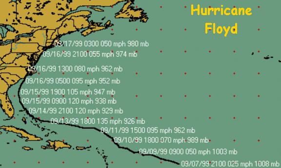
Hurricane FLoyd continued to intensify anxieties of residents here as it moved
NNE into Wilmington NC late Wednesday and then on NNE to just east of this station at midday on
Thursday.
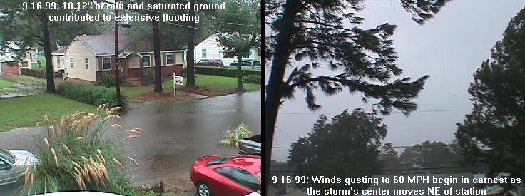
The storm will be remembered here for its downpours, arriving far ahead of the
storm along a trough which was intereacting with the approaching Floyd, and the
subsequent flooding- from rainfall as well as tidal flooding!
Station daily rainfall record amounts associated with Floyd:
Thursday, 9/16 - 3.10"
Total - 10.10"
Wednesday began with downpours moving into the area, particularly over the
mid and lower Peninsula (Hampton, Newport News, Poquoson) at morning rush hour.
Quickly those areas flooded. Similar downpours were scattered across SE VA
and this site for the remainder of the day as bands of rain moved far ahead
of the storm's center. In addition, much of the developing rains resulted
from the interaction of the trough just to the west in the mountains and the
impending storm movement from the south. All of this occurred on already
saturated ground from the extreme rainfalls associated with Dennis earlier in
the month. Unlike Dennis, Floyd produced few isolated tornadoes in Virginia
as it made landfall; but there were more reports of them in North Carolina.
Downpours continued on and off through late night Wednesday into early Thursday. Winds began to increase across the local area Thursday morning as the diminishing Floyd moved to near Endenton, NC then north-northeast to just east of this station as it exited the coast near Cape Henry in northern Virginia Beach.
The lowest observed barometric pressure at this site was 28.988" near noon. Winds increased accordingly and began severe gusting as the center of the storm moved to the northeast with reversed direction SW, W and NW winds gusting to 60 MPH at 12:20 PM. Our max sustained wind speed was 35 MPH from the WNW at about the same time as the max wind gust. At that time, rainfall dropped off dramatically and ended by 1:30 PM.
The remainder of the day brought continued gusty W and NW winds under cloudy skies. The western horizon showed clearing at 8 PM. Evening winds continued to fall off with temps dropping to the lower 60s by midnight.
Other Hurricane Floyd impacts on local rainfall records:
For the month... the 10.12" of rain from Floyd added to the nearly 11" of rain from Dennis (two visits) pushed the monthly rain totals to 21.11", by far the wettest month ever in Portsmouth since records began in 1976, far exceeding the the previous record 15.06" in August of 1992. This months's rainfall is also the greatest monthly total aqueous rainfall ever observed locally by station personnel, since 1963.
For the year... 60.89" of rain was recorded through September 16, 1999. This is a whopping 24.50" above the normal September precip or 167% of the norm.
Note: File extends beyond right margin on smaller screens.

-----------------------------------------------------------------------------------------------------------------------------------
                         TH     Temp   Wind     Hi      Low    Hum      Dew     Wind                                    Temp   Hum     Arc
 Date           Time    Index   Out    Chill    Temp    Temp   Out      Pt.     Speed   Hi      Dir        Rain Barom   In     In      Per
-----------------------------------------------------------------------------------------------------------------------------------
 9/15/99	12:00a	80.0	75.6	75.6	75.7	75.4	93	73.4	4.0	11.0	NNE	   0.00	30.020	75.5	58	60
 9/15/99	 1:00a	80.0	75.5	75.5	75.7	75.4	94	73.7	5.0	11.0	NNE	   0.01	30.009	75.6	59	60
 9/15/99	 2:00a	78.4	75.3	75.3	75.4	75.2	94	73.5	4.0	11.0	NNE	   0.00	29.997	75.6	59	60
 9/15/99	 3:00a	78.4	75.3	75.3	75.4	75.2	94	73.5	5.0	12.0	NNE	   0.00	29.978	75.5	60	60
 9/15/99	 4:00a	80.0	75.6	75.6	75.8	75.4	95	74.1	4.0	15.0	NNE	   0.00	29.960	75.5	60	60
 9/15/99	 5:00a	80.0	75.9	75.9	76.0	75.8	95	74.4	4.0	11.0	NNE	   0.00	29.949	75.4	60	60
 9/15/99	 6:00a	80.0	76.1	--	76.2	76.0	95	74.6	4.0	10.0	NNE	   0.03	29.953	75.5	60	60
 9/15/99	 7:00a	80.0	75.8	75.8	76.2	74.8	95	74.3	4.0	11.0	NNE	   0.17	29.967	77.1	58	60
 9/15/99	 8:00a	76.8	74.0	74.0	74.9	72.3	94	72.2	4.0	7.0	NNE	   0.01	29.970	76.8	58	60
 9/15/99	 9:00a	74.8	72.0	72.0	72.4	71.1	94	70.2	5.0	15.0	N	   0.01	29.960	75.9	59	60
 9/15/99	10:00a	75.0	72.0	72.0	72.9	71.1	95	70.5	5.0	12.0	N	   0.00	29.954	75.0	60	60
 9/15/99	11:00a	76.2	73.0	73.0	73.1	72.9	96	71.8	6.0	13.0	N	   0.10	29.941	74.8	60	60
 9/15/99	12:00p	76.4	73.1	73.1	73.3	72.8	97	72.2	7.0	14.0	NNE	   0.34	29.929	74.6	61	60
 9/15/99	 1:00p	76.6	72.8	72.8	72.9	72.6	98	72.2	4.0	11.0	N	   0.78	29.924	74.5	61	60
 9/15/99	 2:00p	76.6	73.4	73.4	73.7	72.9	98	72.8	4.0	10.0	NNE	   0.13	29.906	74.6	62	60
 9/15/99	 3:00p	77.6	73.7	73.7	73.9	73.6	98	73.1	5.0	11.0	NNE	   0.18	29.880	74.5	62	60
 9/15/99	 4:00p	77.4	74.0	74.0	74.1	73.9	97	73.1	6.0	12.0	NNE	   0.04	29.854	74.4	62	60
 9/15/99	 5:00p	77.6	74.0	--	74.1	74.0	98	73.4	6.0	15.0	NNE	   0.45	29.843	74.5	63	60
 9/15/99	 6:00p	76.6	72.9	72.9	74.1	71.9	98	72.3	7.0	16.0	N	   0.14	29.826	76.1	61	60
 9/15/99	 7:00p	76.6	72.9	72.9	73.2	72.5	98	72.3	7.0	20.0	N	   0.78	29.820	75.4	62	60
 9/15/99	 8:00p	75.8	72.2	72.2	72.5	71.7	99	71.9	7.0	19.0	NNE	   0.76	29.790	75.3	62	60
 9/15/99	 9:00p	75.8	71.8	70.7	71.9	71.6	99	71.5	10.0	20.0	N	   0.49	29.768	76.2	61	60
 9/15/99	10:00p	75.8	72.0	70.9	72.4	71.7	99	71.7	10.0	22.0	N	   1.28	29.718	76.3	62	60
 9/15/99	11:00p	76.8	73.3	72.3	74.2	72.4	99	73.0	10.0	23.0	NNE	   0.72	29.669	76.3	62	60
 9/15/99        11:59p  78.9    74.9    --      75.4    74.1    99      74.6    10.0    24.0    NE         0.58 29.605  76.6    62      60

 9/16/99         1:00a  80.0    75.7    75.7    76.0    75.4    99      75.4    7.0     28.0    NE         0.80 29.569  76.8    62      60
 9/16/99	 2:00a	80.0	76.0	76.0	76.2	75.9	100	76.0	6.0	21.0	SE	   0.87	29.549	76.0	63	60
 9/16/99	 3:00a	80.0	76.1	76.1	76.3	76.0	99	75.8	5.0	15.0	SE	   0.01	29.501	75.6	64	60
 9/16/99	 4:00a	80.0	76.3	76.3	76.5	76.0	99	76.0	6.0	18.0	SE	   0.01	29.441	75.4	64	60
 9/16/99	 5:00a	81.9	76.5	76.5	76.6	76.4	99	76.2	6.0	16.0	SE	   0.01	29.394	75.3	65	60
 9/16/99	 6:00a	81.9	76.5	76.5	76.6	76.5	99	76.2	6.0	24.0	NE	   0.01	29.328	75.2	64	60
 9/16/99	 7:00a	80.0	76.3	--	76.5	76.1	99	76.0	6.0	23.0	NE	   0.15	29.252	75.2	65	60
 9/16/99	 8:00a	80.0	75.8	75.8	76.1	75.4	99	75.5	6.0	24.0	ENE	   0.10	29.198	76.6	63	60
 9/16/99	 9:00a	78.9	74.9	74.9	75.4	74.6	99	74.6	6.0	25.0	SE	   0.05	29.101	77.3	64	60
 9/16/99	10:00a	78.9	74.5	--	74.6	74.3	99	74.2	7.0	33.0	NE	   0.11	28.988	76.8	64	60

 9/17/99	12:00p	67.0	67.0	67.0	67.9	66.3	65	54.9	6.0	16.0	N	   0.00	30.070	74.4	50	60
 9/17/99	 1:00p	69.0	68.6	68.6	69.2	67.9	64	56.0	6.0	16.0	N	   0.00	30.067	75.1	50	60
 9/17/99	 2:00p	70.0	70.0	70.0	70.8	69.1	60	55.5	5.0	13.0	N	   0.00	30.058	76.0	50	60
 9/17/99	 3:00p	70.2	71.3	71.3	71.7	70.7	56	54.8	6.0	15.0	NNE	   0.00	30.055	78.4	47	60
 9/17/99	 4:00p	71.9	72.4	72.4	72.9	71.7	59	57.3	5.0	13.0	N	   0.00	30.053	80.7	45	60
 9/17/99	 5:00p	73.0	73.0	73.0	73.2	72.9	56	56.4	5.0	13.0	NNE	   0.00	30.055	80.9	44	60
 9/17/99	 6:00p	73.0	72.9	72.9	73.0	72.6	58	57.3	5.0	14.0	N	   0.00	30.063	81.4	44	60
 9/17/99	 7:00p	72.0	72.1	72.1	72.6	71.6	60	57.5	4.0	11.0	NNW	   0.00	30.080	81.1	46	60
 9/17/99	 8:00p	69.2	69.4	69.4	71.6	67.3	71	59.6	0.0	0.0	---	   0.00	30.092	81.0	48	60
 9/17/99	 9:00p	66.0	66.0	66.0	67.3	65.0	79	59.3	0.0	5.0	NNW	   0.00	30.105	80.2	49	60
 9/17/99	10:00p	64.2	64.2	64.2	65.0	63.6	81	58.3	0.0	0.0	---	   0.00	30.116	79.0	50	60
 9/17/99	11:00p	63.0	63.0	63.0	63.6	62.3	84	58.1	0.0	0.0	---	   0.00	30.116	77.9	51	60
-----------------------------------------------------------------------------------------------------------------------------------
                         TH     Temp   Wind     Hi      Low    Hum      Dew     Wind                                    Temp   Hum     Arc
 Date           Time    Index   Out    Chill    Temp    Temp   Out      Pt.     Speed   Hi      Dir        Rain Barom   In     In      Per
-----------------------------------------------------------------------------------------------------------------------------------